


For 7000 ft. to 8000 ft.
| Thursday | Thursday Night | Friday | |
|---|---|---|---|
| Weather: | Snow | Cloudy with snow showers decreasing overnight | Cloudy with a chance of snow. |
| Temperatures: | 28 to 34 deg. F. | 16 to 21 deg. F. | 28 to 35 deg. F. |
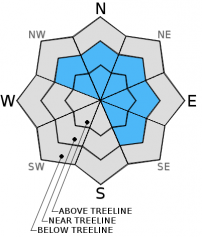
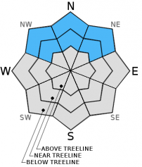
| Mid Slope Winds: | Southwest | Southwest | Southwest |
| Wind Speed: | 20 to 30 mph with gusts to 40 mph | 20 to 30 mph with gusts to 45 mph | 25 to 35 mph with gusts to 55 mph |
| Expected snowfall: | 5 to 8 | up to 2 | up to 5 |
For 8000 ft. to 9000 ft.
| Thursday | Thursday Night | Friday | |
|---|---|---|---|
| Weather: | Snow | Cloudy with snow showers decreasing overnight | Cloudy with a chance of snow. |
| Temperatures: | 21 to 29 deg. F. | 12 to 17 deg. F. | 23 to 30 deg. F. |
| Ridge Top Winds: | Southwest | Southwest | Southwest |
| Wind Speed: | 30 to 40 mph with gusts to 50 mph increasing to 60 mph in the afternoon | 25 to 30 mph with gusts to 45 mph increasing to 35 to 40 mph with gusts to 60 mph after midnight | 40 to 50 mph with gusts to 75 mph |
| Expected snowfall: | 5 to 10 | up to 2 | up to 5 |


