THIS AVALANCHE FORECAST EXPIRED ON February 26, 2014 @ 6:56 am
Avalanche Forecast published on February 25, 2014 @ 6:56 am
Issued by Brandon Schwartz - Tahoe National Forest

Avalanche danger remains LOW for all elevations and aspects. Continue to exercise normal caution while traveling in the backcountry.

1. Low

?

Above Treeline
Generally safe avalanche conditions. Watch for unstable snow on isolated terrain features.

1. Low

?

Near Treeline
Generally safe avalanche conditions. Watch for unstable snow on isolated terrain features.

1. Low

?

Below Treeline
Generally safe avalanche conditions. Watch for unstable snow on isolated terrain features.
    Generally safe avalanche conditions. Watch for unstable snow on isolated terrain features.
Avalanche Problem 1: Loose Wet
  • Type ?
  • Aspect/Elevation ?
  • Likelihood ?
    Certain
    Very Likely
    Likely
    Possible
    Unlikely
  • Size ?
    Historic
    Very Large
    Large
    Small

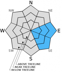
Generally stable snowpack conditions have been observed around the forecast area over the past several days. Loose wet snow avalanche activity is unlikely but not impossible from mid day onwards in areas of significant sun exposure. The most likely locations for wet snow instability to occur is on mid and upper elevation E-SE aspects where the snowpack remains transitional and marginally supportable during melt phase.

recent observations

Observations made yesterday on Jake's Peak (West Shore Tahoe area) and on Round Top Peak (Carson Pass area) revealed overall stable snowpack conditions. Areas of wet surface snow up to 4 to 6 inches deep were noted during the afternoon hours on E-SE-S aspects around 9,000'. Despite significant amounts of wet snow, no wet snow instability was observed.

On Round Top Peak, northerly aspect bed surfaces from slab avalanche activity Feb 8-9 were noted to hold several layers of weak faceted snow. With no overlying slab at this time, there is no current instability issue. As a slab of new snow is placed on top of these weak layers tomorrow night, slab avalanche problems may arise. Similar snowpack conditions were noted Sunday within old northerly aspect bed surfaces on Powderhouse Peak (Luther Pass area).

Weather and CURRENT CONDITIONS
weather summary

One more day of sunny skies, warm air temperatures, and light to moderate speed ridgetop winds is forecast for today. Maximum daytime air temperatures above 7,000' will reach the mid 40s to low 50s. Ridgetop winds are expected to remain out of the south. Transitional weather will occur tomorrow with increasing clouds and wind. Snow showers are likely by tomorrow afternoon ahead of significant accumulating overnight snowfall. Periods of precipitation are expected to continue into early next week.

CONDITIONS ALONG THE SIERRA CREST BETWEEN 8200 FT. AND 9200 FT. IN THE LAST 24 HOURS
6am temperature: 34 to 38 deg. F.
Max. temperature: 43 to 50 deg. F.
Average ridgetop wind direction: South
Average ridgetop wind speed: 19 mph
Maximum ridgetop wind gust: 29 mph
New snowfall: 0 inches
Total snow depth: 35 to 44 inches
Two-Day Mountain Weather Forecast Produced in partnership with the Reno NWS
For 7000 ft. to 8000 ft.
Tuesday Tuesday Night Wednesday
Weather: Sunny skies. Partly cloudy skies, becoming mostly cloudy. Cloudy skies with a slight chance of snow showers in the morning. Snow showers likely in the afternoon. Snow level 6,000' to 7,500'.
Temperatures: 42 to 52 deg. F. 25 to 32 deg. F. 36 to 43 deg. F.
Mid Slope Winds: South Southwest Southwest
Wind Speed: 10 to 15 mph. 10 to 15 mph with gusts to 25 mph. 10 to 15 mph with gusts to 25 mph.
Expected snowfall: 0 0 Up to 1
For 8000 ft. to 9000 ft.
Tuesday Tuesday Night Wednesday
Weather: Sunny skies. Partly cloudy skies, becoming mostly cloudy. Cloudy skies with a slight chance of snow showers in the morning. Snow showers likely in the afternoon.
Temperatures: 44 to 50 deg. F. 25 to 32 deg. F. 36 to 42 deg. F.
Ridge Top Winds: South Southwest South
Wind Speed: 15 to 20 mph with gusts to 30 mph. 10 to 15 mph with gusts to 25 mph, increasing to 20 to 25 mph with gusts to 40 mph after midnight. 20 to 30 mph with gusts to 45 mph.
Expected snowfall: 0 0 Up to 1
Disclaimer

This avalanche advisory is provided through a partnership between the Tahoe National Forest and the Sierra Avalanche Center. This advisory covers the Central Sierra Nevada Mountains between Yuba Pass on the north and Ebbetts Pass on the south. Click here for a map of the forecast area. This advisory applies only to backcountry areas outside established ski area boundaries. This advisory describes general avalanche conditions and local variations always occur. This advisory expires 24 hours after the posted time unless otherwise noted. The information in this advisory is provided by the USDA Forest Service who is solely responsible for its content.