THIS AVALANCHE FORECAST EXPIRED ON March 6, 2014 @ 6:58 am
Avalanche Forecast published on March 5, 2014 @ 6:58 am
Issued by Brandon Schwartz - Tahoe National Forest

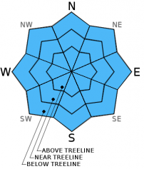
Avalanche danger remains MODERATE for all elevations and aspects on slopes 35 degrees and steeper due to a mix of loose wet snow and lingering wind slabs.

2. Moderate

?

Above Treeline
Heightened avalanche conditions on specific terrain features. Evaluate snow and terrain carefully; identify features of concern.

2. Moderate

?

Near Treeline
Heightened avalanche conditions on specific terrain features. Evaluate snow and terrain carefully; identify features of concern.

2. Moderate

?

Below Treeline
Heightened avalanche conditions on specific terrain features. Evaluate snow and terrain carefully; identify features of concern.
    Heightened avalanche conditions on specific terrain features. Evaluate snow and terrain carefully; identify features of concern.
Avalanche Problem 1: Loose Wet
  • Type ?
  • Aspect/Elevation ?
  • Likelihood ?
    Certain
    Very Likely
    Likely
    Possible
    Unlikely
  • Size ?
    Historic
    Very Large
    Large
    Small

Widespread areas of wet snow are expected today on all aspect below 8,800'. Poor overnight refreeze and areas of rain this morning have kept loose wet avalanche concerns from yesterday ongoing on slopes 37 degrees and steeper. Small human triggered loose wet avalanches are possible today at nearly all elevations on E-SE-S-SW-W aspects and below 8,800' on NW-N-NE aspects. Natural loose wet avalanches will become possible again tonight as rainfall rates increase and snow level rises.

Avalanche Problem 2: Wind Slab
  • Type ?
  • Aspect/Elevation ?
  • Likelihood ?
    Certain
    Very Likely
    Likely
    Possible
    Unlikely
  • Size ?
    Historic
    Very Large
    Large
    Small

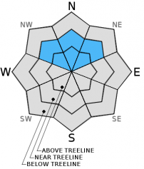
Above 8,800', unstable wind slabs may linger in isolated areas of near treeline and above treeline terrain on NW-N-NE aspects. Isolated human triggered slab avalanches with slab depths of 1 to 3 feet are unlikely but not impossible today in these areas.

recent observations

Observations made yesterday on Jake's Peak (West Shore Tahoe area) and on Donner Peak (Donner Summit area) showed warm air temperatures and minor loose wet snow instability. Small loose wet avalanches were observed to occur naturally beginning around 9 am as wet snow began to fall off of rocks and trees in steep terrain. These conditions continued throughout the day as sun breaks and solar heating through thin fog continued to increase air temperatures and partial clearing allowed for more incoming solar radiation.

Snowpit data collected near the summit of Jake's Peak in a previously wind loaded area indicated that isolated areas of unstable wind slab remain on N-NE aspects above 8,800'.

Weather and CURRENT CONDITIONS
weather summary

A narrow band of moisture is bringing rain to the northwest portion of the forecast area this morning. Thus far 0.1 inches of rain has fallen with snow level around 7,500' to 8,000'. Up to one inch of new snow has accumulated at the highest elevations. The bulk of the rain is expected to end by 10 am with the continued possibility of showers throughout the day. A more significant weather system will impact the forecast area tonight and early tomorrow morning. Up to 0.75 inches of rain are forecast along the Sierra Crest with snow level starting out above 9,000'. Snow level is expected to lower to 8,500' early Thursday morning. At the very end of the storm system, snow level is expected to lower to 6,000' to 6,500'. After calm winds for much of yesterday, southwest ridgetop winds have increased to moderate in speed this morning. Winds are forecast to further increase in speed this afternoon, becoming gale force tonight. Maximum daytime air temperatures are forecast to reach the mid 30s to upper 40s today for areas above 7,000'.

CONDITIONS ALONG THE SIERRA CREST BETWEEN 8200 FT. AND 9200 FT. IN THE LAST 24 HOURS
6am temperature: 33 to 35 deg. F.
Max. temperature: 39 to 46 deg. F.
Average ridgetop wind direction: Southwest
Average ridgetop wind speed: 19 mph
Maximum ridgetop wind gust: 44 mph
New snowfall: 0 to 1 inches
Total snow depth: 49 to 62 inches
Two-Day Mountain Weather Forecast Produced in partnership with the Reno NWS
For 7000 ft. to 8000 ft.
Wednesday Wednesday Night Thursday
Weather: Mostly cloudy skies becoming cloudy. Isolated showers throughout the day. Cloudy skies with rain in the evening. Rain and snow after midnight. Cloudy skies with scattered snow showers in the morning. Isolated snow showers in the afternoon.
Temperatures: 42 to 49 deg. F. 29 to 36 deg. F. 37 to 44 deg. F.
Mid Slope Winds: Southwest Southwest Southwest
Wind Speed: 15 to 20 mph with gusts to 30 mph, increasing to 25 to 30 mph with gusts to 40 mph in the afternoon. 35 to 45 mph. Gusts to 60 mph increasing to 70 mph after midnight. 40 to 45 mph with gusts to 70 mph, decreasing to 30 to 35 mph with gusts to 55 mph in the afternoon.
Expected snowfall: 0 Up to 2 Trace to 2
For 8000 ft. to 9000 ft.
Wednesday Wednesday Night Thursday
Weather: Mostly cloudy skies becoming cloudy. Isolated showers throughout the day. Cloudy skies with rain in the evening. Rain and snow after midnight. Cloudy skies with scattered snow showers in the morning. Isolated snow showers in the afternoon.
Temperatures: 36 to 43 deg. F. 25 to 32 deg. F. 38 to 44 deg. F.
Ridge Top Winds: Southwest Southwest Southwest
Wind Speed: 25 to 30 mph with gusts to 40 mph, increasing to 40 to 45 mph with gusts to 65 mph in the afternoon. 50 to 60 mph with gusts to 95 mph. 50 to 60 mph. Gusts to 90 mph decreasing to 80 mph in the afternoon.
Expected snowfall: 0 2 to 4 Trace to 2
Disclaimer

This avalanche advisory is provided through a partnership between the Tahoe National Forest and the Sierra Avalanche Center. This advisory covers the Central Sierra Nevada Mountains between Yuba Pass on the north and Ebbetts Pass on the south. Click here for a map of the forecast area. This advisory applies only to backcountry areas outside established ski area boundaries. This advisory describes general avalanche conditions and local variations always occur. This advisory expires 24 hours after the posted time unless otherwise noted. The information in this advisory is provided by the USDA Forest Service who is solely responsible for its content.