THIS AVALANCHE FORECAST EXPIRED ON March 9, 2014 @ 7:46 am
Avalanche Forecast published on March 8, 2014 @ 6:46 am
Issued by Andy Anderson - Tahoe National Forest - Sierra Avalanche Center

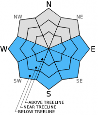
MODERATE avalanche danger will form on slopes steeper than 35 degrees on the sun exposed SE-S-SW aspects and pockets of MODERATE danger may form on the E and W aspects. Loose wet avalanches will become possible again today due to daytime warming and strong March sunshine.

2. Moderate

?

Above Treeline
Heightened avalanche conditions on specific terrain features. Evaluate snow and terrain carefully; identify features of concern.

2. Moderate

?

Near Treeline
Heightened avalanche conditions on specific terrain features. Evaluate snow and terrain carefully; identify features of concern.

2. Moderate

?

Below Treeline
Heightened avalanche conditions on specific terrain features. Evaluate snow and terrain carefully; identify features of concern.
    Heightened avalanche conditions on specific terrain features. Evaluate snow and terrain carefully; identify features of concern.
Avalanche Problem 1: Loose Wet
  • Type ?
  • Aspect/Elevation ?
  • Likelihood ?
    Certain
    Very Likely
    Likely
    Possible
    Unlikely
  • Size ?
    Historic
    Very Large
    Large
    Small

Loose wet snow instabilities will again become possible today as the strong spring sunshine and daytime highs in the upper 40's to low 50's above 7000 ft. melt and soften the upper part of the snowpack. The majority of wet snow instabilities that do occur today should remain limited to small roller balls, pinwheels, and small wet snow sluffs. However, a few isolated wet snow instabilities could entrain enough snow to cause problems for backcountry travelers.

recent observations

Yesterday a few inches of soft melt/freeze snow existed above a still frozen crust on the SW and W aspects between 3 and 5 pm from 7400 ft to 8500 ft in the Underwood Bowl area near Bear Valley. Reports from earlier in the day indicated that the S-SE-E aspects had softened much earlier and that deeper unsupportable wet  snow existed on the S aspects during the hottest part of the day. The E-SE-S aspects started to refreeze by late afternoon.

On the northerly aspects and on shaded areas on other aspects the surface remained frozen throughout the day. A natural cornice collapse did occur on a wind loaded N-NE facing slope near 8500 ft. This cornice collapse did not trigger any signs of slab instability on the wind loaded slope. Snowpit tests and data on a similar wind loaded test slope showed a strong and stable snowpack below a firm, frozen rain crust.

Weather and CURRENT CONDITIONS
weather summary

The high pressure ridge over the region should bring another day of mostly sunny warm weather. The winds should also shift to the south and decrease today. Most of the remote sensors above 8000 ft. already showed temperatures in the mid 30's at 6 am. Temperatures should continue to climb, and the forecast calls for daytime highs in the upper 40's to low 50's above 7000 ft. today. Some thin high clouds should begin to move into the area this afternoon ahead of a low pressure system. Cloud cover and southwest winds should continue to increase overnight as this system gets closer. By tomorrow the forecast area could begin to see some rain and high elevation snow (snow levels are forecasted between 8500 and 9000 ft. for tomorrow).

CONDITIONS ALONG THE SIERRA CREST BETWEEN 8200 FT. AND 9200 FT. IN THE LAST 24 HOURS
6am temperature: 26 to 38 deg. F.
Max. temperature: 36 to 42 deg. F.
Average ridgetop wind direction: East
Average ridgetop wind speed: 20 mph
Maximum ridgetop wind gust: 41 mph
New snowfall: 0 inches
Total snow depth: 43 to 56 inches
Two-Day Mountain Weather Forecast Produced in partnership with the Reno NWS
For 7000 ft. to 8000 ft.
Saturday Saturday Night Sunday
Weather: Partly cloudy to mostly sunny Mostly cloudy Cloudy with a chance of rain
Temperatures: 47 to 54 deg. F. 26 to 36 deg. F. 42 to 52 deg. F.
Mid Slope Winds: Variable Southwest Southwest
Wind Speed: Light 10 to 15 mph with gusts to 25 mph after midnight 15 to 20 mph with gusts to 30 mph
Expected snowfall: 0 0 trace
For 8000 ft. to 9000 ft.
Saturday Saturday Night Sunday
Weather: Partly cloudy to mostly sunny Mostly cloudy Cloudy with a chance of rain and snow
Temperatures: 42 to 50 deg. F. 24 to 35 deg. F. 35 to 45 deg. F.
Ridge Top Winds: South Southwest Southwest
Wind Speed: 10 to 15 mph with gusts to 30 mph in the afternoon 15 to 25 mph with gusts to 30 mph increasing to 40 mph after midnight 20 to 30 mph with gusts to 45 mph
Expected snowfall: 0 0 trace
Disclaimer

This avalanche advisory is provided through a partnership between the Tahoe National Forest and the Sierra Avalanche Center. This advisory covers the Central Sierra Nevada Mountains between Yuba Pass on the north and Ebbetts Pass on the south. Click here for a map of the forecast area. This advisory applies only to backcountry areas outside established ski area boundaries. This advisory describes general avalanche conditions and local variations always occur. This advisory expires 24 hours after the posted time unless otherwise noted. The information in this advisory is provided by the USDA Forest Service who is solely responsible for its content.