THIS AVALANCHE FORECAST EXPIRED ON April 5, 2014 @ 6:43 am
Avalanche Forecast published on April 4, 2014 @ 6:43 am
Issued by Brandon Schwartz - Tahoe National Forest

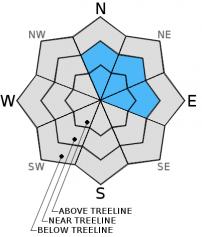
Avalanche danger remains LOW for all elevations and aspects. Isolated areas of small unstable wind slabs may form today in wind loaded areas near and above treeline on N-NE-E aspects. Normal caution is advised.

1. Low

?

Above Treeline
Generally safe avalanche conditions. Watch for unstable snow on isolated terrain features.

1. Low

?

Near Treeline
Generally safe avalanche conditions. Watch for unstable snow on isolated terrain features.

1. Low

?

Below Treeline
Generally safe avalanche conditions. Watch for unstable snow on isolated terrain features.
    Generally safe avalanche conditions. Watch for unstable snow on isolated terrain features.
Avalanche Problem 1: Wind Slab
  • Type ?
  • Aspect/Elevation ?
  • Likelihood ?
    Certain
    Very Likely
    Likely
    Possible
    Unlikely
  • Size ?
    Historic
    Very Large
    Large
    Small

Small wind slabs will likely form this afternoon in the most heavily wind loaded areas near and above treeline on N-NE-E aspects. These slabs are expected to be less than 6 inches thick and only extend a few feet down slope. For the most part these new wind slabs will not pose a significant threat to backcountry travelers. The nature of convective snow showers is to provide very short periods of high intensity snowfall and isolated areas of increased snowfall accumulation. Given this snowfall pattern, formation of an isolated wind slab with sufficient size to potentially bury or injure a person is not out of the realm of possibility for this afternoon.

recent observations

Observations made yesterday on Red Vista (Carson Pass area) and on Tamarack Peak (Mount Rose backcountry) revealed little to no evidence of snowpack instability. On Red Vista, formal snowpit tests and ski cuts in previously wind loaded areas yielded no signs of unstable wind slabs. Formal snowpit tests targeting near crust facet layers just below the recent storm snow yielded no signs of unstable persistent slabs. On Tamarack Peak, formal snowpit tests revealed no signs of unstable wind slabs and produced highly variable and inconsistent results on the near crust facet layer at the base of the recent storm snow.

Other recent observations from around the forecast area over the past several days have all pointed towards a significant stability improvement of the persistent slab problem arising from the near crust facet layer that was rapidly loaded during the last storm cycle. Data indicates that this weak layer has adjusted to the new load and that persistent slab avalanches are becoming highly unlikely.

Weather and CURRENT CONDITIONS
weather summary

A weak weather system will move through the forecast area today. Cloudy skies will prevail with snow shower activity increasing during the afternoon hours. Around 2 inches of new snowfall is expected above 6,000', mainly from convective snow showers. Ridgetop winds are moderate in speed out of the southwest this morning and are forecast to continue through tonight. Maximum daytime air temperatures for areas above 7,000' are expected to reach the upper 20s to mid 30s today. High pressure will begin to build over the region tomorrow, lasting through the week.

CONDITIONS ALONG THE SIERRA CREST BETWEEN 8200 FT. AND 9200 FT. IN THE LAST 24 HOURS
6am temperature: 23 to 27 deg. F.
Max. temperature: 33 to 38 deg. F.
Average ridgetop wind direction: Southwest
Average ridgetop wind speed: 23 mph
Maximum ridgetop wind gust: 39 mph
New snowfall: Trace to 1 inches
Total snow depth: 57 to 73 inches
Two-Day Mountain Weather Forecast Produced in partnership with the Reno NWS
For 7000 ft. to 8000 ft.
Friday Friday Night Saturday
Weather: Cloudy skies with scattered snow showers in the morning. Snow showers in the afternoon. Mostly cloudy skies with isolated snow showers in the evening. Partly cloudy skies.
Temperatures: 29 to 36 deg. F. 17 to 24 deg. F. 36 to 43 deg. F.
Mid Slope Winds: Southwest West North
Wind Speed: 15 to 20 mph. Gusts to 30 mph in the afternoon. 15 to 20 mph with gusts to 30 mph in the evening, becoming light. Light winds increasing to 10 to 15 mph with gusts to 25 mph in the afternoon.
Expected snowfall: Up to 2 0 to trace 0
For 8000 ft. to 9000 ft.
Friday Friday Night Saturday
Weather: Cloudy skies with scattered snow showers in the morning. Snow showers in the afternoon. Mostly cloudy skies with isolated snow showers in the evening. Partly cloudy skies.
Temperatures: 28 to 34 deg. F. 19 to 25 deg. F. 35 to 41 deg. F.
Ridge Top Winds: Southwest West shifting to northwest. Northwest shifting to north.
Wind Speed: 10 to 15 mph with gusts to 25 mph, increasing to 20 to 25 mph with gusts to 35 mph in the afternoon. 20 to 25 mph with gusts to 35 mph, decreasing to 10 to 15 mph after midnight. 10 to 15 mph increasing to 20 to 25 mph with gusts to 40 mph in the afternoon.
Expected snowfall: 1 to 2 0 to trace 0
Disclaimer

This avalanche advisory is provided through a partnership between the Tahoe National Forest and the Sierra Avalanche Center. This advisory covers the Central Sierra Nevada Mountains between Yuba Pass on the north and Ebbetts Pass on the south. Click here for a map of the forecast area. This advisory applies only to backcountry areas outside established ski area boundaries. This advisory describes general avalanche conditions and local variations always occur. This advisory expires 24 hours after the posted time unless otherwise noted. The information in this advisory is provided by the USDA Forest Service who is solely responsible for its content.