THIS AVALANCHE FORECAST EXPIRED ON April 21, 2014 @ 6:35 am
Avalanche Forecast published on April 20, 2014 @ 6:35 am
Issued by Brandon Schwartz - Tahoe National Forest

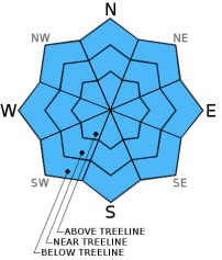
In response to daytime warming, avalanche danger will quickly rise from to LOW danger early this morning to MODERATE danger later this morning for all elevations and aspects on slopes 37 degrees and steeper. Human triggered loose wet avalanches will become possible. Natural avalanches remain unlikely.

2. Moderate

?

Above Treeline
Heightened avalanche conditions on specific terrain features. Evaluate snow and terrain carefully; identify features of concern.

2. Moderate

?

Near Treeline
Heightened avalanche conditions on specific terrain features. Evaluate snow and terrain carefully; identify features of concern.

2. Moderate

?

Below Treeline
Heightened avalanche conditions on specific terrain features. Evaluate snow and terrain carefully; identify features of concern.
    Heightened avalanche conditions on specific terrain features. Evaluate snow and terrain carefully; identify features of concern.
Avalanche Problem 1: Loose Wet
  • Type ?
  • Aspect/Elevation ?
  • Likelihood ?
    Certain
    Very Likely
    Likely
    Possible
    Unlikely
  • Size ?
    Historic
    Very Large
    Large
    Small

As daytime warming progresses, the poor to decent snow surface refreeze that occurred last night will transition from supportable crust to deep wet snow. Partly cloudy skies last night will have limited the potential for radiational cooling. The best snow surface refreeze will have occurred in areas where air temperatures were actually below freezing. Once the surface refreeze melts and the snow surface becomes unsupportable, enough unconsolidated wet snow will exist for human triggered pinwheels, roller balls, and loose avalanches to become possible on all aspects at all elevations.

recent observations

Observations made yesterday in Poison Canyon and on Mt. Reba (Bear Valley Backcountry) revealed a poor overnight refreeze and a rapidly melting snowpack on SE-S-SW aspects. Snow surface conditions consisted of a weak 1 inch thick melt freeze crust during the early morning hours that quickly gave way to breakable crust and then deep wet snow over the course of about 30 minutes. Many areas of bare ground existed on SE-S-SW aspects between 7,600' and 8,700'. On NW-N-NE aspects the snowpack remains 3 to 6 feet deep. On the N side of Mt. Reba, many areas of naturally triggered cornice collapse had occurred, with no evidence of recent slab avalanche activity.

Weather and CURRENT CONDITIONS
weather summary

High pressure in place over the forecast area will keep air temperatures above average today and tomorrow. A strong cold front is forecast to impact the region on Tuesday. A significant pacific storm system is expected to bring rain and snow to the forecast area next weekend. This morning, remote sensors above 8,200' are reporting minimum overnight air temperatures in the low to upper 30s. Maximum daytime air temperatures are forecast to reach the upper 40s to low 60s today for areas above 7,000'. Partly cloudy skies last night are expected to continue today. Ridgetop winds shifted from southwest to east just prior to sunrise this morning. Light and variable ridgetop winds are expected today.

CONDITIONS ALONG THE SIERRA CREST BETWEEN 8200 FT. AND 9200 FT. IN THE LAST 24 HOURS
6am temperature: 30 to 38 deg. F.
Max. temperature: 47 to 51 deg. F.
Average ridgetop wind direction: Southwest
Average ridgetop wind speed: 25 mph
Maximum ridgetop wind gust: 53 mph
New snowfall: 0 inches
Total snow depth: 15 to 50 inches
Two-Day Mountain Weather Forecast Produced in partnership with the Reno NWS
For 7000 ft. to 8000 ft.
Sunday Sunday Night Monday
Weather: Partly cloudy skies. Partly cloudy skies. Mostly cloudy skies.
Temperatures: 52 to 62 deg. F. 28 to 38 deg. F. 51 to 61 deg. F.
Mid Slope Winds: Variable Variable Southwest
Wind Speed: Light winds Light winds 10 to 15 mph with gusts to 25 mph, increasing to 20 to 30 mph with gusts to 45 mph in the afternoon.
Expected snowfall: 0 0 0
For 8000 ft. to 9000 ft.
Sunday Sunday Night Monday
Weather: Partly cloudy skies. Partly cloudy skies. Mostly cloudy skies.
Temperatures: 48 to 58 deg. F. 26 to 36 deg. F. 46 to 56 deg. F.
Ridge Top Winds: Variable Southeast Southwest
Wind Speed: Light winds Light winds becoming 10 to 15 mph with gusts to 25 mph after midnight. 15 to 25 mph with gusts to 35 mph, increasing to 35 to 50 mph with gusts to 60 mph in the afternoon.
Expected snowfall: 0 0 0
Disclaimer

This avalanche advisory is provided through a partnership between the Tahoe National Forest and the Sierra Avalanche Center. This advisory covers the Central Sierra Nevada Mountains between Yuba Pass on the north and Ebbetts Pass on the south. Click here for a map of the forecast area. This advisory applies only to backcountry areas outside established ski area boundaries. This advisory describes general avalanche conditions and local variations always occur. This advisory expires 24 hours after the posted time unless otherwise noted. The information in this advisory is provided by the USDA Forest Service who is solely responsible for its content.