THIS AVALANCHE FORECAST EXPIRED ON December 5, 2014 @ 7:25 am
Avalanche Forecast published on December 4, 2014 @ 7:25 am
Issued by Andy Anderson - Tahoe National Forest - Sierra Avalanche Center

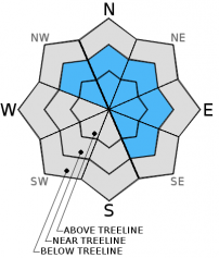
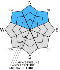
Above 8000 ft. on slopes 32 degrees and steeper, human-triggered avalanches remain possible on NW-N-NE aspects in all terrain and on near and above treeline E-SE aspects. MODERATE avalanche danger exists in these areas due to wind slabs and possible persistent slabs. Higher elevation slopes with the most snow represent both the most dangerous places to go and the places where people want to recreate. Don't let early season excitement overrule good judgment and decision making.

2. Moderate

?

Above Treeline
Heightened avalanche conditions on specific terrain features. Evaluate snow and terrain carefully; identify features of concern.

2. Moderate

?

Near Treeline
Heightened avalanche conditions on specific terrain features. Evaluate snow and terrain carefully; identify features of concern.

2. Moderate

?

Below Treeline
Heightened avalanche conditions on specific terrain features. Evaluate snow and terrain carefully; identify features of concern.
    Heightened avalanche conditions on specific terrain features. Evaluate snow and terrain carefully; identify features of concern.
Avalanche Problem 1: Wind Slab
  • Type ?
  • Aspect/Elevation ?
  • Likelihood ?
    Certain
    Very Likely
    Likely
    Possible
    Unlikely
  • Size ?
    Historic
    Very Large
    Large
    Small

New snow and strong winds continue to load the leeward slopes. The wind slabs on these slopes continue to grow in size and extent. The new snow and wind has also created large and fragile cornices above the wind-loaded slopes. Human triggered wind slab avalanches large enough to bury or injure a person remain possible today on the wind-loaded N-NE-E aspects and on the cross-loaded NW and SE aspects above 8000 ft. These slabs will become larger and more fragile as elevation and snow depth increase.

Avalanche Problem 2: Persistent Slab
  • Type ?
  • Aspect/Elevation ?
  • Likelihood ?
    Certain
    Very Likely
    Likely
    Possible
    Unlikely
  • Size ?
    Historic
    Very Large
    Large
    Small

Weak layers of sugary snow (facets) exist near the base of the snowpack on northerly aspects above 8000 ft. in many areas. In some areas below 8800 ft. the warmer weather and wet snow/rain has allowed these weak layers to start to gain strength so that they can support the heavy snow above them. However, not enough data exists to say that this strengthening has started to occur everywhere these persistent weak layers remain. Slopes with these weak layers remain suspect especially at higher elevations where temperatures remained colder and all of the recent precipitation fell as snow. Observations like slope cuts and previous tracks are not reliable indications of stability when dealing with persistent slabs. Avoiding areas where these layers might exist or sticking to lower angle slopes without steeper terrain above them are the only mitigation options for persistent slabs. Any other technique is just rolling the dice.

recent observations

Yesterday on Caslte Peak, Grouse Rocks, and on Tamarack Peak snow levels seemed to fluctuate between 7400 ft. and 8400 ft. Water had formed in every layer of the snowpack on Castle Peak as high as 8800 ft. making the old persistent weak layers start to stick together. Tests on these layers in the Castle Peak area and snowpit data from 8100 ft. near Grouse Rocks did not reveal signs of instability on these older weak layers. However, in the Tamarack Peak area at higher elevations some collapsing did occur on a NE aspect. It remains unknown whether or not these collapses resulted from the old persistent weak layers near the base of the snowpack failing.

Ski cuts and freezer-sized cornice pieces dropped on wind-loaded test slopes on Castle Peak did not cause any noticable cracking or collapsing on the wind-loaded test slopes.

Weather and CURRENT CONDITIONS
weather summary

Another 1.4 to 1.9 inches of water fell across the forecast area in the last 24 hours. Above 8200 ft. this precipitation fell as 6 to 11 inches of heavy wet snow. Below that elevation the precipitation fell as a mix of rain and snow, and only 1 to 3 inches of snow accumulated. Areas below 7500 ft. received mostly rain. The southwest winds remained strong averaging between 35 and 45 mph with gusts in the 90's over the the Sierra Crest. Both the precipitation and winds should begin to decrease today as the storm moves out of the area. Skies should start to clear with only partly cloudy conditions predicted for tonight. Cloud cover and winds should begin to increase again tomorrow afternoon as another system approaches the forecast area Friday night. Temperatures should remain warmer than normal with daytime highs in the upper 30's to mid 40's between 7000 ft. and 8000 ft. and low to mid 30's above 8000 ft.

CONDITIONS ALONG THE SIERRA CREST BETWEEN 8200 FT. AND 9200 FT. IN THE LAST 24 HOURS
6am temperature: 30 to 35 deg. F.
Max. temperature: 32 to 37 deg. F.
Average ridgetop wind direction: Southwest
Average ridgetop wind speed: 35 to 45 mph
Maximum ridgetop wind gust: 91 mph
New snowfall: Below 8200 ft: Mix of rain and up to 3 inches of snow | Above 8200 ft: 6 to 11 inches
Total snow depth: 16 to 29 inches
Two-Day Mountain Weather Forecast Produced in partnership with the Reno NWS
For 7000 ft. to 8000 ft.
Thursday Thursday Night Friday
Weather: Mostly cloudy with some scattered showers. Snow levels around 7500 ft. Partly cloudy becoming mostly cloudy with isolated snow showers. Mostly cloudy with a slight chance of snow showers in the afternoon.
Temperatures: 34 to 41 deg. F. 24 to 31 deg. F. 35 to 42 deg. F.
Mid Slope Winds: Southwest Variable South
Wind Speed: 15 to 20 mph with gusts to 30 mph Light Light increasing to 15 to 20 mph with gusts to 30 mph in the afternoon
Expected snowfall: up to 2 0 0
For 8000 ft. to 9000 ft.
Thursday Thursday Night Friday
Weather: Mostly cloudy with some scattered showers. Partly cloudy becoming mostly cloudy with isolated snow showers. Mostly cloudy with a slight chance of snow showers in the afternoon.
Temperatures: 29 to 36 deg. F. 24 to 31 deg. F. 29 to 36 deg. F.
Ridge Top Winds: Southwest Southwest Southwest shifting to the south in the afternoon
Wind Speed: 25 to 35 mph with gusts to 50 mph 15 to 25 mph with gusts to 35 mph 15 to 20 mph with gusts to 30 mph increasing to 25 to 30 mph with gusts to 45 mph in the afternoon
Expected snowfall: up to 2 0 0
Disclaimer

This avalanche advisory is provided through a partnership between the Tahoe National Forest and the Sierra Avalanche Center. This advisory covers the Central Sierra Nevada Mountains between Yuba Pass on the north and Ebbetts Pass on the south. Click here for a map of the forecast area. This advisory applies only to backcountry areas outside established ski area boundaries. This advisory describes general avalanche conditions and local variations always occur. This advisory expires 24 hours after the posted time unless otherwise noted. The information in this advisory is provided by the USDA Forest Service who is solely responsible for its content.