THIS AVALANCHE FORECAST EXPIRED ON December 11, 2014 @ 6:51 am
Avalanche Forecast published on December 10, 2014 @ 6:51 am
Issued by Andy Anderson - Tahoe National Forest - Sierra Avalanche Center

The avalanche danger will remain LOW for all elevations and aspects today. Continue to use normal caution when traveling in the backcountry.

Expect the avalanche danger to increase dramatically starting tomorrow as a strong winter storm arrives over the forecast area. Wind slab, storm slab, and deep persistent slab avalanches could all become problems during this storm.

1. Low

?

Above Treeline
Generally safe avalanche conditions. Watch for unstable snow on isolated terrain features.

1. Low

?

Near Treeline
Generally safe avalanche conditions. Watch for unstable snow on isolated terrain features.

1. Low

?

Below Treeline
Generally safe avalanche conditions. Watch for unstable snow on isolated terrain features.
    Generally safe avalanche conditions. Watch for unstable snow on isolated terrain features.
Avalanche Problem 1: Normal Caution
  • Type ?
  • Aspect/Elevation ?
  • Likelihood ?
    Certain
    Very Likely
    Likely
    Possible
    Unlikely
  • Size ?
    Historic
    Very Large
    Large
    Small

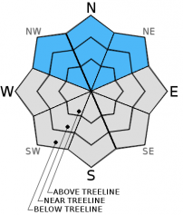
Even though a persistent weak layer of loose sugary snow (facets) still lingers on some NW-N-NE aspects above 9000-9500 ft, triggering a persistent slab avalanche has become unlikely. As new snow adds significant weight to the snowpack over the next few days, it could overload this weak layer, and destructive deep persistent slab avalanches could occur. Excitement for snow covered mountains and fresh tracks can make people forget about things like persistent weak layers lurking in the snowpack. A slope breaking around a person and avalanching often represents the only warning that persistent slabs like those that could again become likely during this storm give people. For some advice on dealing with persistent slabs check out this page here.

recent observations

Recent data from around the forecast area indicates that weak layers still exist near the base of the snowpack above 9000 ft. on some NW-N-NE aspects. Tests on the layers of weak sugary snow continue to imply that if these layers break the resulting fractures can travel along the persistent weak layers. At the top of the snowpack a mix of soft snow and crusts exists depending on elevation and aspect. Yesterday on Poison Peak in the Bear Valley area up to 8500 ft. a supportable rain crust existed on the snow surface on all aspects. On the northerly aspects soft loose snow existed below this crust. 

Weather and CURRENT CONDITIONS
weather summary

The forecast calls for another day of cloudy skies and mild weather today. Southwest winds should start to increase during the day as a strong winter storm approaches the region. By tonight and through tomorrow the southwest winds should average between 45 and 70 mph with gusts as high as 105 mph in the 7000 to 8000 ft. range. Above 8000 ft. and along the ridgelines, even stronger winds should prevail with average wind speeds in the 65 to 95 mph range and gusts as high as 140 mph by tomorrow. While some precipitation may begin tonight, most of the precipitation should occur late Thursday afternoon and into Friday with the most intense precipitation falling Thursday night through early Friday morning. Snow levels should begin around 7500 ft. and drop to 5000 to 5500 ft. by Thursday night. Overall 18 to 36 inches of snow could accumulate above 7000 ft. by the end of the day on Friday. The forecast calls for 7 to 14 inches at Lake Level.

The NWS has issued a winter storm warning from 1pm on Thursday through 1pm on Friday as well as a high wind warning from 10pm tonight through 1 pm on Thursday.

CONDITIONS ALONG THE SIERRA CREST BETWEEN 8200 FT. AND 9200 FT. IN THE LAST 24 HOURS
6am temperature: 32 to 44 deg. F.
Max. temperature: 43 to 45 deg. F.
Average ridgetop wind direction: Southwest
Average ridgetop wind speed: 15 to 25 mph
Maximum ridgetop wind gust: 42 mph
New snowfall: 0 inches
Total snow depth: 12 to 27 inches
Two-Day Mountain Weather Forecast Produced in partnership with the Reno NWS
For 7000 ft. to 8000 ft.
Wednesday Wednesday Night Thursday
Weather: Mostly cloudy Cloudy with a slight chance of rain and snow after midnight. Snow level around 7500 ft. Cloudy with a chance of rain and snow in the morning. Rain and snow becoming likely in the afternoon. Snow levels starting between 7000 and 7500 ft. and dropping to 5000 to 5500 ft. by the evening.
Temperatures: 41 to 49 deg. F. 29 to 36 deg. F. 38 to 44 deg. F.
Mid Slope Winds: Southwest Southwest shifting to south after midnight South
Wind Speed: 15 to 20 mph with gusts to 30 mph increasing to 30 to 35 mph with gusts to 50 mph in the afternoon 45 to 50 mph with gusts to 75 mph increasing to 55 to 60 mph with gusts to 90 mph after midnight 60 to 70 mph with gusts to 105 mph
Expected snowfall: 0 0 2 to 4
For 8000 ft. to 9000 ft.
Wednesday Wednesday Night Thursday
Weather: Mostly cloudy Cloudy with a slight chance of snow after midnight Cloudy with a chance of rain and snow in the morning. Snow becoming likely in the afternoon
Temperatures: 36 to 46 deg. F. 27 to 34 deg. F. 36 to 42 deg. F.
Ridge Top Winds: Southwest Southwest South
Wind Speed: 25 to 35 mph with gusts to 40 mph increasing to 50 to 55 mph with gusts to 85 mph in the afternoon 65 to 70 mph with gusts to 105 mph increasing to 80 to 85 mph with gusts to 125 mph after midnight 80 to 85 mph with gusts to 130 mph increasing to 90 to 95 mph with gusts to 140 mph in the afternoon.
Expected snowfall: 0 0 3 to 6
Disclaimer

This avalanche advisory is provided through a partnership between the Tahoe National Forest and the Sierra Avalanche Center. This advisory covers the Central Sierra Nevada Mountains between Yuba Pass on the north and Ebbetts Pass on the south. Click here for a map of the forecast area. This advisory applies only to backcountry areas outside established ski area boundaries. This advisory describes general avalanche conditions and local variations always occur. This advisory expires 24 hours after the posted time unless otherwise noted. The information in this advisory is provided by the USDA Forest Service who is solely responsible for its content.