THIS AVALANCHE FORECAST EXPIRED ON December 18, 2014 @ 6:53 am
Avalanche Forecast published on December 17, 2014 @ 6:53 am
Issued by Andy Anderson - Tahoe National Forest - Sierra Avalanche Center

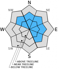
Human-triggered wind slab avalanches remain possible today. MODERATE avalanche danger exists on wind-loaded NW-N-NE-E-SE aspects 35 degrees and steeper in near and above treeline terrain. Use clues like cornices, drifted snow, ripples in the snow surface, and other wind created textures to help determine where wind slabs may exist. Convex rollovers, areas near rocks, unsupported slopes, couloirs/gullies, and other complex terrain represent the most likely places to trigger wind slabs.

2. Moderate

?

Above Treeline
Heightened avalanche conditions on specific terrain features. Evaluate snow and terrain carefully; identify features of concern.

2. Moderate

?

Near Treeline
Heightened avalanche conditions on specific terrain features. Evaluate snow and terrain carefully; identify features of concern.

1. Low

?

Below Treeline
Generally safe avalanche conditions. Watch for unstable snow on isolated terrain features.
    Heightened avalanche conditions on specific terrain features. Evaluate snow and terrain carefully; identify features of concern.
Avalanche Problem 1: Wind Slab
  • Type ?
  • Aspect/Elevation ?
  • Likelihood ?
    Certain
    Very Likely
    Likely
    Possible
    Unlikely
  • Size ?
    Historic
    Very Large
    Large
    Small

Even though last night's additional snowfall remained meager, combined with moderate southwest winds it should have been enough to cause the existing wind slabs on wind-loaded NW-N-NE-E-SE aspects in near and above treeline terrain to remain fragile today. Human-triggered avalanches involving the wind slabs will remain possible today. While any steep wind-loaded slope poses a potential problem, convex rollovers, areas near rocks, unsupported slopes, couloirs/gullies, and other complex terrain represent the most likely places to trigger wind slabs. These wind slabs rest on a layer of softer snow that can serve as a weak layer, and these slabs can break above the person who triggers them. Due to shifting winds during the last few days, wind slabs may have formed in some atypical areas (including some isolated W aspects). Use clues like cornices, drifted snow, ripples in the snow surface, and other wind created textures to help determine where wind slabs may exist. Many of these wind slabs measure 1 to 2 ft. in depth, and avalanches resulting from their failure could involve enough snow to bury a person especially in the most heavily wind-loaded areas or in areas where terrain traps magnify the consequences of the wind slabs.

Over time these wind slabs will start to bond to the layers below them. Patience, good judgment, cautious terrain selection, and conservative decision making can keep people from triggering more wind slab avalanches today. As a person involved in one of yesterday's avalanches said, "Early season stoke can easily blind decision making. Ski smart & travel smart."

recent observations

Yesterday, several skier-triggered wind slab avalanches occurred along the Sierra Crest. On Castle Peak a party triggered one on N facing slope (more info here). Another party triggered one in the Grouse Rocks area on a NE aspect (more info and photos here). Both avalanches occurred on wind-loaded slopes in near treeline terrain with crowns about 1 ft. depth. Both parties triggered the slides at convex rollovers and the resulting avalanches broke above the person who triggered them. In both cases the avalanche caught and carried the person who triggered it but did not bury him. No injuries occurred but both of the triggers said things could have been much worse. Another party reported a small wind slab avalanche on an unusual W aspect on a convex slope in the Donner Summit area. East of the Lake in the Tamarack Peak area, some shooting cracks occurred on wind loaded test slopes and snowpit tests on the test slopes indicated that the layer of softer snow below the wind slabs remained fragile (more info, photos, snowpit).

Weather and CURRENT CONDITIONS
weather summary

Last night's storm system ended up splitting and most of its precipitation moved south of the region. 1 to 4 inches of new snow has fallen in the last 24 hrs. As this weak system continues to move south and east some snow showers will remain along the Sierra Crest with the best chances for accumulation today in areas south of Hwy 50. Some snow showers may continue in areas east of Lake Tahoe as well due to lake effect snow. Winds should remain moderate out of the southwest today. The forecast calls for another weak disturbance passing over the region tonight. By tomorrow morning the area could see another 1 to 4 inches of snow. Skies should start to clear and winds should diminish tomorrow as a small, short-lived ridge forms over the area on Thursday.

CONDITIONS ALONG THE SIERRA CREST BETWEEN 8200 FT. AND 9200 FT. IN THE LAST 24 HOURS
6am temperature: 21 to 27 deg. F.
Max. temperature: 24 to 33 deg. F.
Average ridgetop wind direction: Southwest
Average ridgetop wind speed: 15 to 20 mph
Maximum ridgetop wind gust: 44 mph
New snowfall: 2 to 4 inches
Total snow depth: 26 to 39 inches
Two-Day Mountain Weather Forecast Produced in partnership with the Reno NWS
For 7000 ft. to 8000 ft.
Wednesday Wednesday Night Thursday
Weather: Cloudy with scattered snow showers Mostly cloudy with isolated snow showers Partly cloudy becoming mostly cloudy
Temperatures: 26 to 33 deg. F. 20 to 24 deg. F. 31 to 35 deg. F.
Mid Slope Winds: Southwest Variable Variable
Wind Speed: 10 to 15 mph Light Light
Expected snowfall: up to 2 1 to 2 0
For 8000 ft. to 9000 ft.
Wednesday Wednesday Night Thursday
Weather: Cloudy with scattered snow showers Mostly cloudy with isolated snow showers Partly cloudy becoming mostly cloudy
Temperatures: 24 to 29 deg. F. 15 to 22 deg. F. 26 to 32 deg. F.
Ridge Top Winds: Southwest Southwest Southwest
Wind Speed: 15 to 20 mph with gusts to 30 mph in the morning 10 to 15 mph with gusts to 25 mph after midnight 10 to 15 mph
Expected snowfall: up to 2 1 to 2 0
Disclaimer

This avalanche advisory is provided through a partnership between the Tahoe National Forest and the Sierra Avalanche Center. This advisory covers the Central Sierra Nevada Mountains between Yuba Pass on the north and Ebbetts Pass on the south. Click here for a map of the forecast area. This advisory applies only to backcountry areas outside established ski area boundaries. This advisory describes general avalanche conditions and local variations always occur. This advisory expires 24 hours after the posted time unless otherwise noted. The information in this advisory is provided by the USDA Forest Service who is solely responsible for its content.