THIS AVALANCHE FORECAST EXPIRED ON December 29, 2014 @ 6:40 am
Avalanche Forecast published on December 28, 2014 @ 6:40 am
Issued by Brandon Schwartz - Tahoe National Forest

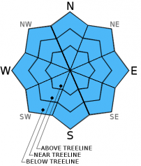
Avalanche danger remains LOW for all elevations and aspects. Normal caution is advised. Long sliding falls on exposed rain crust are possible near and above treeline in wind scoured areas, especially on N-NE-E aspects.

1. Low

?

Above Treeline
Generally safe avalanche conditions. Watch for unstable snow on isolated terrain features.

1. Low

?

Near Treeline
Generally safe avalanche conditions. Watch for unstable snow on isolated terrain features.

1. Low

?

Below Treeline
Generally safe avalanche conditions. Watch for unstable snow on isolated terrain features.
    Generally safe avalanche conditions. Watch for unstable snow on isolated terrain features.
Avalanche Problem 1: Normal Caution
  • Type ?
  • Aspect/Elevation ?
  • Likelihood ?
    Certain
    Very Likely
    Likely
    Possible
    Unlikely
  • Size ?
    Historic
    Very Large
    Large
    Small

Avalanche concerns are minimal at this time. Increasing NW to W ridgetop winds will create some areas of blowing snow today. Very limited amounts of snow are available for wind transport. Any new wind slabs that form near and above treeline today will remain small and shallow, presenting very little hazard to backcountry travelers. Continue to exercise normal caution by exposing one person at a time to avalanche terrain. The most likely significant hazard to encounter today is exposed rain crust in NE wind scoured areas near and above treeline. Travel on or above areas of exposed rain crust introduces the possibility for long sliding falls.

recent observations

Observations made yesterday on Waterhouse Peak (Luther Pass area) and on Castle Peak (Donner Summit area) revealed no evidence of snowpack instability. In wind protected areas below treeline, a few inches of recent storm snow remained unconsolidated. Near and above treeline areas have been significantly affected by recent NE winds. Pockets of shallow, stable wind transported snow existed in lee areas while exposed rain crust existed in wind scoured areas.

Weather and CURRENT CONDITIONS
weather summary

Partly cloudy skies and above average air temperatures are forecast for today ahead of an approaching cold front. This morning's air temperature inversion is not as strong as it was 24 hours ago due to increased cloud cover. Remote sensors are reporting air temperatures this morning in the mid 20s to low 30s between 8,000' and 9,000'. Westerly ridgetop winds are forecast to increase to moderate in speed today, further increasing in speed tonight and tomorrow.

CONDITIONS ALONG THE SIERRA CREST BETWEEN 8200 FT. AND 9200 FT. IN THE LAST 24 HOURS
6am temperature: 23 to 31 deg. F.
Max. temperature: 28 to 41 deg. F.
Average ridgetop wind direction: West shifting to southeast
Average ridgetop wind speed: 18 mph
Maximum ridgetop wind gust: 29 mph
New snowfall: 0 inches
Total snow depth: 26 to 38 inches
Two-Day Mountain Weather Forecast Produced in partnership with the Reno NWS
For 7000 ft. to 8000 ft.
Sunday Sunday Night Monday
Weather: Partly cloudy skies. Clear skies. Mostly sunny skies.
Temperatures: 32 to 37 deg. F. 17 to 24 deg. F. 27 to 33 deg. F.
Mid Slope Winds: W W W
Wind Speed: 10 to 20 mph with gusts to 30 mph. 15 to 25 mph with gusts to 35 mph. 20 to 25 mph with gusts to 40 mph.
Expected snowfall: 0 0 0
For 8000 ft. to 9000 ft.
Sunday Sunday Night Monday
Weather: Partly cloudy skies. Clear skies. Mostly sunny skies.
Temperatures: 29 to 34 deg. F. 17 to 22 deg. F. 23 to 30 deg. F.
Ridge Top Winds: NW W to NW W
Wind Speed: 20 to 35 mph with gusts to 55 mph. 30 to 45 mph with gusts to 70 mph. 30 to 45 mph with gusts up to 70 mph.
Expected snowfall: 0 0 0
Disclaimer

This avalanche advisory is provided through a partnership between the Tahoe National Forest and the Sierra Avalanche Center. This advisory covers the Central Sierra Nevada Mountains between Yuba Pass on the north and Ebbetts Pass on the south. Click here for a map of the forecast area. This advisory applies only to backcountry areas outside established ski area boundaries. This advisory describes general avalanche conditions and local variations always occur. This advisory expires 24 hours after the posted time unless otherwise noted. The information in this advisory is provided by the USDA Forest Service who is solely responsible for its content.