THIS AVALANCHE FORECAST EXPIRED ON January 6, 2015 @ 6:50 am
Avalanche Forecast published on January 5, 2015 @ 6:50 am
Issued by Andy Anderson - Tahoe National Forest - Sierra Avalanche Center

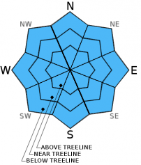
The avalanche danger remains LOW on all elevations and aspects. Small wet snow instabilities may form in isolated areas due to daytime warming. Continue to use normal caution and practice safe travel habits when traveling in the backcountry.

1. Low

?

Above Treeline
Generally safe avalanche conditions. Watch for unstable snow on isolated terrain features.

1. Low

?

Near Treeline
Generally safe avalanche conditions. Watch for unstable snow on isolated terrain features.

1. Low

?

Below Treeline
Generally safe avalanche conditions. Watch for unstable snow on isolated terrain features.
    Generally safe avalanche conditions. Watch for unstable snow on isolated terrain features.
Avalanche Problem 1: Normal Caution
  • Type ?
  • Aspect/Elevation ?
  • Likelihood ?
    Certain
    Very Likely
    Likely
    Possible
    Unlikely
  • Size ?
    Historic
    Very Large
    Large
    Small

Some small wet snow instabilities like roller balls, pinwheels, or small wet loose sluffs may from today on some sun-exposed slopes. Some cloud cover combined with low sun angles, some light north winds, and some overnight refreezing should prevent larger wet snow instabilities from forming. In other more shaded areas a strong well bonded snowpack with a weaker snow near the surface and no slab above this weaker snow exists. As a result of the limited warming and lack of slabs above the potential weak layers natural and human triggered avalanches remain unlikely today. Unlikely does not mean impossible and small isolated areas of unstable snow could linger on isolated terrain features especially in complex or extreme terrain like couliors, gullies, areas around cliffs, or unsupported slopes. Practice safe travel habits like traveling one at a time in avalanche terrain and regrouping in safe zones. Other backcountry hazards remain including icy conditions on some exposed near and above treeline slopes and a shallow snowpack with lots of obstacles.

recent observations

Yesterday observations on Silver Peak showed firm crusts on the near and above treeline slopes exposed to the N-NE winds and softer snow above an eroding rain crust on the more protected near and below treeline northerly aspects. In the Mt. Rose backcountry on Fireplug similar conditions with soft snow on top of a thin rain crust existed in the sheltered areas. On Tamarack Peak the rain crust on the scoured N-NE-E aspects has deteriorated into a thin variable crust that has become breakable in some places, supportable in other areas, and almost nonexistent in others. Below the rain crust a thin potential weak layer continues to form in all of these areas. Tests on this layer show that it remains mostly unreactive at this point. Snowpit data indicates a strong and well bonded snowpack below that thin weak layer. On sun exposed E-SE-S-SW-W aspects on Fireplug yesterday, several inches of wet, sticky snow had formed on the surface by 1 pm.

Weather and CURRENT CONDITIONS
weather summary

After a mostly clear night, some high clouds may form over parts of the forecast area today leading to partly cloudy skies. As the high pressure ridge establishes itself over the region, the clouds should dissipate and the winds should become light and variable. By tomorrow expect a mostly sunny, warm day with little to no wind above 7000 ft. The forecast calls for daytime highs in the upper 40's and low 50's for both today and tomorrow in the mountains. As usual when the calm conditions prevail some cooler temperatures may exist in the valleys and lower elevations where cold air settles and remains trapped. 

CONDITIONS ALONG THE SIERRA CREST BETWEEN 8200 FT. AND 9200 FT. IN THE LAST 24 HOURS
6am temperature: 31 to 41 deg. F.
Max. temperature: 42 to 47 deg. F.
Average ridgetop wind direction: Southwest shifting to north last night
Average ridgetop wind speed: 10 to 15 mph
Maximum ridgetop wind gust: 28 mph
New snowfall: 0 inches
Total snow depth: 26 to 37 inches
Two-Day Mountain Weather Forecast Produced in partnership with the Reno NWS
For 7000 ft. to 8000 ft.
Monday Monday Night Tuesday
Weather: Mostly cloudy becoming partly cloudy Partly cloudy Partly cloudy becoming sunny
Temperatures: 45 to 52 deg. F. 25 to 33 deg. F. 46 to 53 deg. F.
Mid Slope Winds: Variable Variable Variable
Wind Speed: Light Light Light
Expected snowfall: 0 0 0
For 8000 ft. to 9000 ft.
Monday Monday Night Tuesday
Weather: Mostly cloudy becoming partly cloudy Partly cloudy Partly cloudy becoming sunny
Temperatures: 42 to 49 deg. F. 30 to 36 deg. F. 44 to 51 deg. F.
Ridge Top Winds: Northwest Variable Variable
Wind Speed: 10 to 15 mph in the morning becoming light during the day. Light Light
Expected snowfall: 0 0 0
Disclaimer

This avalanche advisory is provided through a partnership between the Tahoe National Forest and the Sierra Avalanche Center. This advisory covers the Central Sierra Nevada Mountains between Yuba Pass on the north and Ebbetts Pass on the south. Click here for a map of the forecast area. This advisory applies only to backcountry areas outside established ski area boundaries. This advisory describes general avalanche conditions and local variations always occur. This advisory expires 24 hours after the posted time unless otherwise noted. The information in this advisory is provided by the USDA Forest Service who is solely responsible for its content.