THIS AVALANCHE FORECAST EXPIRED ON January 18, 2015 @ 7:00 am
Avalanche Forecast published on January 17, 2015 @ 7:00 am
Issued by Andy Anderson - Tahoe National Forest - Sierra Avalanche Center

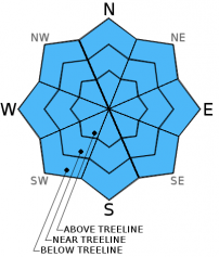
The avalanche danger remains LOW on all elevations and aspects. Some wet loose instabilities may become possible if any rain continues to fall on the snowpack today especially in areas north of I80 where the best chances for rain exist. Any wet snow instabilities that do form should remain small and isolated. Continue to practice safe travel habits and thoughtful decision making when traveling in the backcountry.

1. Low

?

Above Treeline
Generally safe avalanche conditions. Watch for unstable snow on isolated terrain features.

1. Low

?

Near Treeline
Generally safe avalanche conditions. Watch for unstable snow on isolated terrain features.

1. Low

?

Below Treeline
Generally safe avalanche conditions. Watch for unstable snow on isolated terrain features.
    Generally safe avalanche conditions. Watch for unstable snow on isolated terrain features.
Avalanche Problem 1: Loose Wet
  • Type ?
  • Aspect/Elevation ?
  • Likelihood ?
    Certain
    Very Likely
    Likely
    Possible
    Unlikely
  • Size ?
    Historic
    Very Large
    Large
    Small

Cloud cover, overnight temperatures above freezing, and continued light rain showers in some areas last night should have prevented a decent refreeze from occurring. This lack of refreeze combined with continued warm temperatures today and the slight possibility of continued light rain showers will mean that some small isolated wet loose snow instabilities may be possible today on any aspect or elevation where rain continues to fall. The last few weeks of melt-freeze cycles have created drainage channels in the snowpack that allow water to quickly drain out of the snowpack. This ability for the snowpack to deal with free water should help limit any wet snow instabilities that might form today to pinwheels, roller balls and small wet loose snow sluffs. If any wet snow instabilities do occur they will most likely happen in areas north of I80 that have received the most rain and where light rain remains possible today. In areas that have not received rain and do not receive rain today wet snow instabilities should remain unlikely.

recent observations

Yesterday light rain created a thin soft layer of wet snow on all aspects and elevations up to at least 7800 ft. on Lincoln Ridge near Yuba Pass. This wet snow rested on top of a supportable snowpack in this area, and small (less than 12 inches in diameter) skier-triggered pinwheels represented the only observed wet snow instabilities. Snowpit data and tests targeting the weak layer near the buried rain crust indicated that this layer has gained some strength.

Weather and CURRENT CONDITIONS
weather summary

Yesterday some areas along the Sierra Crest received light rain up to at least 9000 ft. Most of this rain occurred in areas north of Tahoe City, but a few other remote sensors in the southern part of the forecast area did indicate some showers. Southwest winds, mostly cloudy skies, and warm temperatures should continue through the weekend as a series of small systems pass nearby the forecast area. A very slight chance (10% or less) for some precipitation does exist through tomorrow in areas north of I80. The chances of receiving any precipitation decline quickly south of I80. Snow levels should remain between 8000 and 9000 ft, so any precipitation that does fall will likely fall as rain.

CONDITIONS ALONG THE SIERRA CREST BETWEEN 8200 FT. AND 9200 FT. IN THE LAST 24 HOURS
6am temperature: 32 to 38 deg. F.
Max. temperature: 35 to 43 deg. F.
Average ridgetop wind direction: West and southwest
Average ridgetop wind speed: 30 mph
Maximum ridgetop wind gust: 73 mph
New snowfall: Rain: .02-.08 inches | Snow: 0 inches
Total snow depth: 23 to 33 inches
Two-Day Mountain Weather Forecast Produced in partnership with the Reno NWS
For 7000 ft. to 8000 ft.
Saturday Saturday Night Sunday
Weather: Mostly cloudy with a slight chance of light rain especially north of I80. Snow level between 8000 and 9000 ft. Mostly cloudy with a slight chance of light rain especially north of I80. Snow level between 8000 and 9000 ft. Mostly cloudy with a slight chance of light rain especially north of I80. Snow level between 8000 and 9000 ft.
Temperatures: 44 to 50 deg. F. 26 to 33 deg. F. 44 to 50 deg. F.
Mid Slope Winds: Southwest Southwest Southwest
Wind Speed: 15 to 20 mph with gusts to 25 mph increasing to 35 mph in the afternoon 20 to 30 mph with gusts to 45 mph 20 to 30 mph with gusts to 45 mph
Expected snowfall: 0 0 0
For 8000 ft. to 9000 ft.
Saturday Saturday Night Sunday
Weather: Mostly cloudy with a slight chance of light rain or snow especially north of I80. Snow level between 8000 and 9000 ft. Mostly cloudy with a slight chance of light rain or snow especially north of I80. Snow level between 8000 and 9000 ft. Mostly cloudy with a slight chance of light rain or snow especially north of I80. Snow level between 8000 and 9000 ft.
Temperatures: 37 to 44 deg. F. 27 to 34 deg. F. 40 to 46 deg. F.
Ridge Top Winds: Southwest Southwest Southwest
Wind Speed: 20 to 30 mph with gusts to 45 mph 35 to 45 mph with gusts to 60 mph increasing to 70 mph after midnight 35 to 45 mph with gusts to 70 mph
Expected snowfall: 0 0 0
Disclaimer

This avalanche advisory is provided through a partnership between the Tahoe National Forest and the Sierra Avalanche Center. This advisory covers the Central Sierra Nevada Mountains between Yuba Pass on the north and Ebbetts Pass on the south. Click here for a map of the forecast area. This advisory applies only to backcountry areas outside established ski area boundaries. This advisory describes general avalanche conditions and local variations always occur. This advisory expires 24 hours after the posted time unless otherwise noted. The information in this advisory is provided by the USDA Forest Service who is solely responsible for its content.