THIS AVALANCHE FORECAST EXPIRED ON February 2, 2015 @ 6:56 am
Avalanche Forecast published on February 1, 2015 @ 6:56 am
Issued by Brandon Schwartz - Tahoe National Forest

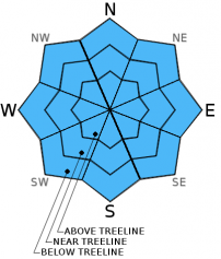
Avalanche danger remains LOW for all elevations and aspects. Isolated areas of minor instability are unlikely but not impossible. Normal caution is advised.

1. Low

?

Above Treeline
Generally safe avalanche conditions. Watch for unstable snow on isolated terrain features.

1. Low

?

Near Treeline
Generally safe avalanche conditions. Watch for unstable snow on isolated terrain features.

1. Low

?

Below Treeline
Generally safe avalanche conditions. Watch for unstable snow on isolated terrain features.
    Generally safe avalanche conditions. Watch for unstable snow on isolated terrain features.
Avalanche Problem 1: Normal Caution
  • Type ?
  • Aspect/Elevation ?
  • Likelihood ?
    Certain
    Very Likely
    Likely
    Possible
    Unlikely
  • Size ?
    Historic
    Very Large
    Large
    Small

Avalanche concerns for today remain minimal. Small shallow isolated wind slabs are unlikely but not impossible in near and above treeline areas. Some redistribution of snow on the ground is possible today with the switch from NE to W winds. The greatest threat from triggering an isolated wind slab is secondary terrain hazards such as rocks, trees, and cliffs that one could be pushed into or over rather than the size of the avalanche itself.

Areas of surface wet snow will form today in response to daytime warming. Any areas of associated surface wet snow instability are expected to remain small and inconsequential in the form of human triggered roller balls, pinwheels, and small loose wet sluffs.

Snowpack stability across the forecast area is good but not perfect. Exercise normal caution and employ best practice travel techniques while traveling in and around avalanche terrain.

recent observations

Observations made yesterday on Castle Peak (Donner Summit area) found small shallow wind slabs 2 to 4 inches deep on NW aspects in near treeline terrain at 8,500'. Very minimal amounts of wind transport were observed with slab creation having previously occurred under similar NE winds on January 28. The slab/weak layer combination showed no evidence of instability in the areas traveled with skier triggered cracking highly localized and without propagation. Areas of full shade all day had resisted snow surface melt with areas of shallow unconsolidated recent storm snow lingering. Sun exposed areas were in full melt-freeze regime. Wet surface snow 1 to 2 inches deep was observed on SE-S aspects at 12:15 pm. Convective cooling from NE winds slowed snow surface melt during the mid morning hours. By early afternoon, snow surface melt was occurring in nearly all sun exposed areas on SE-S-SW aspects.

Observations received yesterday from Relay Peak (Mount Rose area) showed no further evidence of instability associated with the crust/rounding facet combo that exists in the upper snowpack in many locations around the forecast area. This relative weak snow below strong crust is most pronounced in the Mount Rose region, but has been observed to varying degrees around the rest of the forecast area. It remains worth keeping an eye on , but is not a current instability concern.

Weather and CURRENT CONDITIONS
weather summary

High pressure in place over the forecast area will begin to weaken ahead of a storm system moving into the Pacific Northwest. Winds have shifted to the west this morning and are expected to increase to light to moderate in speed over the ridgetops this afternoon. Mid and high level cloud cover is expected to gradually increase today and tonight, especially for areas north of Hwy 50. An air temperature inversion is in place this morning with air temperatures in the upper 30s to mid 40s for most locations above 7,200'. Colder air in the 20s has settled down onto most of the mountain valley floors. Maximum daytime air temperatures are forecast to reach the mid 40s to mid 50s today for areas above 7,000'. For Monday expect mostly cloudy skies, moderate speed west winds, and air temperatures a few degrees cooler than today.

CONDITIONS ALONG THE SIERRA CREST BETWEEN 8200 FT. AND 9200 FT. IN THE LAST 24 HOURS
6am temperature: 31 to 44 deg. F.
Max. temperature: 42 to 45 deg. F.
Average ridgetop wind direction: Northeast
Average ridgetop wind speed: 25 mph
Maximum ridgetop wind gust: 70 mph
New snowfall: 0 inches
Total snow depth: 23 to 32 inches
Two-Day Mountain Weather Forecast Produced in partnership with the Reno NWS
For 7000 ft. to 8000 ft.
Sunday Sunday Night Monday
Weather: Partly cloudy skies. Partly cloudy skies becoming mostly cloudy. Mostly cloudy skies.
Temperatures: 49 to 54 deg. F. 30 to 35 deg. F. 44 to 50 deg. F.
Mid Slope Winds: W W SW
Wind Speed: Light winds increasing to 10 to 15 mph. 10 to 15 mph 10 to 20 mph with gusts to 30 mph.
Expected snowfall: 0 0 0
For 8000 ft. to 9000 ft.
Sunday Sunday Night Monday
Weather: Partly cloudy skies. Partly cloudy skies becoming mostly cloudy. Mostly cloudy skies.
Temperatures: 43 to 48 deg. F. 29 to 34 deg. F. 40 to 45 deg. F.
Ridge Top Winds: W W W
Wind Speed: Light winds increasing to 15 to 20 mph with gusts to 30 mph in the afternoon. 15 to 30 mph with gusts to 45 mph. 15 to 30 mph with gusts to 45 mph.
Expected snowfall: 0 0 0
Disclaimer

This avalanche advisory is provided through a partnership between the Tahoe National Forest and the Sierra Avalanche Center. This advisory covers the Central Sierra Nevada Mountains between Yuba Pass on the north and Ebbetts Pass on the south. Click here for a map of the forecast area. This advisory applies only to backcountry areas outside established ski area boundaries. This advisory describes general avalanche conditions and local variations always occur. This advisory expires 24 hours after the posted time unless otherwise noted. The information in this advisory is provided by the USDA Forest Service who is solely responsible for its content.