THIS AVALANCHE FORECAST EXPIRED ON February 9, 2015 @ 6:58 am
Avalanche Forecast published on February 8, 2015 @ 6:58 am
Issued by Andy Anderson - Tahoe National Forest - Sierra Avalanche Center

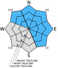
Human triggered avalanches remain possible today. Above 8,000 ft, MODERATE avalanche danger exists on NW-N-NE-E-SE aspects on slopes 35 degrees and steeper due to lingering dense wind slabs and storm slabs. Some isolated areas of unstable storm slabs may linger on isolated terrain features on other aspects. Don't let the new snow lead to careless decision making. Specifically choosing slopes based on slope angle will be the difference between "getting lucky" and "getting it done" in the backcountry today.

2. Moderate

?

Above Treeline
Heightened avalanche conditions on specific terrain features. Evaluate snow and terrain carefully; identify features of concern.

2. Moderate

?

Near Treeline
Heightened avalanche conditions on specific terrain features. Evaluate snow and terrain carefully; identify features of concern.

2. Moderate

?

Below Treeline
Heightened avalanche conditions on specific terrain features. Evaluate snow and terrain carefully; identify features of concern.
    Heightened avalanche conditions on specific terrain features. Evaluate snow and terrain carefully; identify features of concern.
Avalanche Problem 1: Wind Slab
  • Type ?
  • Aspect/Elevation ?
  • Likelihood ?
    Certain
    Very Likely
    Likely
    Possible
    Unlikely
  • Size ?
    Historic
    Very Large
    Large
    Small

Human-triggereable wind slabs may still remain on wind loaded and cross loaded NW-N-NE-E-SE aspects. Most of these slabs should exist in near and above treeline terrain but some could have formed in below treeline terrain or in more sheltered areas due to the strong winds during this storm. These dense heavy wind slabs rest on top of old crusts that have a layer of softer snow below them on some northerly aspects. While these slabs may have become more difficult to trigger, human triggered avalanches involving these winds slabs remain possible. These dense and hard wind slabs can break above the person who triggers them or could be triggered by the 2nd, 3rd, 4th, or nth person on the slope. Typical obvious clues of instability and other tests may not provide reliable data as to whether or not these wind slabs will break. Wind loaded slopes steeper than 35 degrees above 8000 ft, represent the most likely places to find unstable wind slabs. Wind loaded slopes 38 degrees and steeper, couliors, unsupported slopes above cliffs, or slopes in complex or extreme terrain could be especially problematic today. Some of these slabs could fail on or just below the old snow surfaces and could propogate along those old snow layers.

Avalanche Problem 2: Storm Slab
  • Type ?
  • Aspect/Elevation ?
  • Likelihood ?
    Certain
    Very Likely
    Likely
    Possible
    Unlikely
  • Size ?
    Historic
    Very Large
    Large
    Small

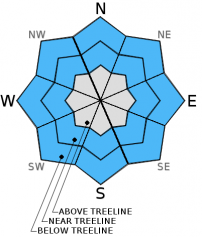
Some unstable storm slabs may linger in wind protected areas above 8,000 ft. While these have become more difficult to trigger today due to consolidation in the new snow, human triggered storm slab avalanches with depths of 6 inches to 1.5 ft, will remain possible on slopes steeper than 35 degrees today in wind protected areas in both near and below treeline terrain. Some of these slabs could fail on or just below the old snow surfaces. Northerly aspects steeper than 38 degrees above 9000 ft. where the soft layer below the old crusts remains will represent the best places to trigger these slabs.

recent observations

Yesterday a skier triggered a wind slab avalanche north of Relay Peak in the Mt. Rose backcountry. This slide measured about 80 ft. in width with a 2 ft. crown and broke above the spot where the skier initially triggered the avalanche. It ran down hill for about 300 ft. This slide occurred on a 40 degree, N facing slope at about 9500 ft. On the east ridge of Tamarack Peak some snowpit tests indicated instability, while on Relay Peak snowpit tests did not show signs of instability. On Castle Peak snowpit data and observations showed quickly consolidating new snow. Farther south near Frog Lake off of Carson Pass, snowpit data again showed instability at the base of the new snow. The suspect weak layer in the reported avalanche and the tests on the east ridge of Tamarack and near Frog Lake was the layer of softer snow below the old rain crust. This layer could be starting to act more like a persistent weak layer in some places due to the new slab on top of it. 

Weather and CURRENT CONDITIONS
weather summary

Above 7500 ft. another 2 to 4 inches of snow fell across the forecast area in the last 24 hours. Below this elevation much of the precipitation fell as rain. Today the forecast calls for warm temperatures and mostly cloudy skies for much of the day. Some light rain showers may occur and snow levels should start between 8000 and 8500 ft. The south and southwest winds should continue, and they should start increasing this afternoon as another storm system moves into the area. Precipitation should also increase this afternoon, and snow levels should start to fall. By this evening snow levels should drop into the 7000 ft range and continue falling to around 6000 to 6500 ft. by early Monday morning. By tomorrow afternoon another 6 to 12 inches of new snow could accumulate above 7000 ft. with 12 to 18 inches possible at the higher elevations along the Sierra Crest. Most of the precipitation should fall overnight tonight and during the morning tomorrow. By mid morning on Monday, snowfall should become less widespread. Some snow showers, moderate southwest winds, and cooler temperatures should remain through Monday.

CONDITIONS ALONG THE SIERRA CREST BETWEEN 8200 FT. AND 9200 FT. IN THE LAST 24 HOURS
6am temperature: 30 to 37 deg. F.
Max. temperature: 32 to 37 deg. F.
Average ridgetop wind direction: Southwest
Average ridgetop wind speed: 30 mph
Maximum ridgetop wind gust: 59 mph
New snowfall: 2 to 4 inches
Total snow depth: 30 to 44 inches
Two-Day Mountain Weather Forecast Produced in partnership with the Reno NWS
For 7000 ft. to 8000 ft.
Sunday Sunday Night Monday
Weather: Mostly cloudy to cloudy with a chance of rain. Cloudy with snow and rain Mostly cloudy with snow showers likely
Temperatures: 39 to 46 deg. F. 26 to 33 deg. F. 31 to 38 deg. F.
Mid Slope Winds: South Southwest Southwest
Wind Speed: 25 to 30 mph with gusts to 45 mph increasing to 35 to 40 mph with gusts to 65 mph in the afternoon 30 to 40 mph with gusts to 60 mph 20 to 30 mph with gusts to 55 mph decreasing to gusts to 40 mph in the afternoon
Expected snowfall: 0 4 to 8 3 to 5
For 8000 ft. to 9000 ft.
Sunday Sunday Night Monday
Weather: Mostly cloudy to cloudy with a chance of rain and snow. Snow Mostly cloudy with snow showers likely
Temperatures: 35 to 42 deg. F. 24 to 31 deg. F. 27 to 34 deg. F.
Ridge Top Winds: Southwest shifting to the south in the afternoon Southwest Southwest
Wind Speed: 40 to 45 mph with gusts to 65 mph increasing to 50 to 55 mph with gusts to 85 mph in the afternoon 40 to 50 mph with gusts to 75 mph 40 to 45 mph with gusts to 70 mph decreasing to 30 to 35 mph with gusts to 55 mph in the afternoon
Expected snowfall: up to 2 5 to 10 3 to 5
Disclaimer

This avalanche advisory is provided through a partnership between the Tahoe National Forest and the Sierra Avalanche Center. This advisory covers the Central Sierra Nevada Mountains between Yuba Pass on the north and Ebbetts Pass on the south. Click here for a map of the forecast area. This advisory applies only to backcountry areas outside established ski area boundaries. This advisory describes general avalanche conditions and local variations always occur. This advisory expires 24 hours after the posted time unless otherwise noted. The information in this advisory is provided by the USDA Forest Service who is solely responsible for its content.