THIS AVALANCHE FORECAST EXPIRED ON February 13, 2015 @ 6:55 am
Avalanche Forecast published on February 12, 2015 @ 6:55 am
Issued by Brandon Schwartz - Tahoe National Forest

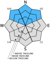
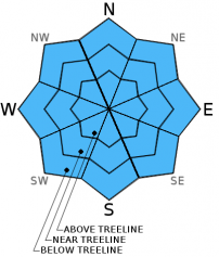
Avalanche danger is LOW for all elevations and aspects. Human triggered avalanches are unlikely, but far from impossible today. A very low probability, high consequence scenario lingers with a difficult to trigger large persistent slab avalanche concern in isolated areas above 8,700' on NW-N-NE aspects on slopes 37 degrees and steeper. Isolated small human triggered loose wet avalanches remain a possibility again today as warming continues.

1. Low

?

Above Treeline
Generally safe avalanche conditions. Watch for unstable snow on isolated terrain features.

1. Low

?

Near Treeline
Generally safe avalanche conditions. Watch for unstable snow on isolated terrain features.

1. Low

?

Below Treeline
Generally safe avalanche conditions. Watch for unstable snow on isolated terrain features.
    Generally safe avalanche conditions. Watch for unstable snow on isolated terrain features.
Avalanche Problem 1: Persistent Slab
  • Type ?
  • Aspect/Elevation ?
  • Likelihood ?
    Certain
    Very Likely
    Likely
    Possible
    Unlikely
  • Size ?
    Historic
    Very Large
    Large
    Small

Snowpack stability is improving, but data is still insufficient to entirely rule out the lingering concern for very difficult to trigger large persistent slab avalanches above 8,700' on NW-N-NE aspects on slopes 37 degrees and steeper. A weak layer of lower density rounds and rounding faceted snow crystals exists at the base of the recent storm snow in these areas and has been an instability issue in recent days. Given the nature of this type of avalanche problem, human triggered avalanche activity is possible on previously tracked slopes where the necessary trigger point has remained undisturbed. Areas around shallow buried or exposed rocks and along the base of cliff bands represent the most likely trigger points for this avalanche problem.

Avalanche Problem 2: Loose Wet
  • Type ?
  • Aspect/Elevation ?
  • Likelihood ?
    Certain
    Very Likely
    Likely
    Possible
    Unlikely
  • Size ?
    Historic
    Very Large
    Large
    Small

As another round of rapid warming occurs today, human triggered loose wet avalanches will become possible on all aspects at all elevations following the formation of surface wet snow. The majority of instability is expected to take the form of roller balls and pinwheels. Small loose wet avalanches are possible in isolated areas on all aspects on slopes 37 degrees and steeper.

recent observations

Recent observations from around the forecast area including those made yesterday on Incline Lake Peak (Mount Rose area) continue to indicate improving snowpack stability. The recent storm snow and associate weak layer of lower density old snow just below the old/new snow interface on NW-N-NE aspects above 8,700' continues to settle, gain strength, and adjust to the new snowpack load. Rapid warming conditions occurred yesterday with 1 to 4 inches of surface wet snow formation observed on all but the most heavily shaded N aspects on Incline Lake Peak by mid day. Wet surface snow along with melt water and snow falling off of trees was widespread on all aspects up to the summit at 9,760'. Evidence of surface wet snow instability was limited to natural roller balls and human triggered pinwheels up until departure from the area mid afternoon. Surface melt-freeze crust is expected to have formed in the vast majority of areas last night.

Weather and CURRENT CONDITIONS
weather summary

High pressure remains in place over the forecast area. Thin high level cloud cover of varying thickness and well above average air temperatures are expected for today and tomorrow. Air temperature inversion conditions are in place again this morning with most sensors between 8,000' and 9,000' reporting air temperatures in the 40s this morning. Air temperatures are in the upper 20s to mid 30s on the mountain valley floors. Maximum daytime air temperatures are forecast to reach the low to mid 50s today for areas above 7,000'. Ridgetop winds are forecast to remain light and variable today and tonight, eventually becoming light southwest tomorrow afternoon.

CONDITIONS ALONG THE SIERRA CREST BETWEEN 8200 FT. AND 9200 FT. IN THE LAST 24 HOURS
6am temperature: 36 to 48 deg. F.
Max. temperature: 49 to 57 deg. F.
Average ridgetop wind direction: Variable
Average ridgetop wind speed: 8 mph
Maximum ridgetop wind gust: 17 mph
New snowfall: 0 inches
Total snow depth: 32 to 50 inches
Two-Day Mountain Weather Forecast Produced in partnership with the Reno NWS
For 7000 ft. to 8000 ft.
Thursday Thursday Night Friday
Weather: High level clouds creating partly cloudy skies. High level clouds creating partly cloudy skies. High level clouds creating partly cloudy skies.
Temperatures: 50 to 57 deg. F. 32 to 38 deg. F. 56 to 62 deg. F.
Mid Slope Winds: Variable Variable Variable
Wind Speed: Light winds Light winds Light winds
Expected snowfall: 0 0 0
For 8000 ft. to 9000 ft.
Thursday Thursday Night Friday
Weather: High level clouds creating partly cloudy skies. High level clouds creating partly cloudy skies. High level clouds creating partly cloudy skies.
Temperatures: 50 to 57 deg. F. 32 to 39 deg. F. 47 to 54 deg. F.
Ridge Top Winds: Variable Variable Variable winds in the morning, becoming southwest in the afternoon.
Wind Speed: Light winds Light winds Light winds in the morning becoming 10 to 15 mph in the afternoon.
Expected snowfall: 0 0 0
Disclaimer

This avalanche advisory is provided through a partnership between the Tahoe National Forest and the Sierra Avalanche Center. This advisory covers the Central Sierra Nevada Mountains between Yuba Pass on the north and Ebbetts Pass on the south. Click here for a map of the forecast area. This advisory applies only to backcountry areas outside established ski area boundaries. This advisory describes general avalanche conditions and local variations always occur. This advisory expires 24 hours after the posted time unless otherwise noted. The information in this advisory is provided by the USDA Forest Service who is solely responsible for its content.