THIS AVALANCHE FORECAST EXPIRED ON February 20, 2015 @ 6:35 am
Avalanche Forecast published on February 19, 2015 @ 6:35 am
Issued by Brandon Schwartz - Tahoe National Forest

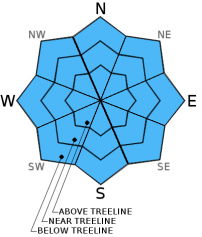
Avalanche danger remains LOW for all elevations and aspects.

Normal caution is advised.

1. Low

?

Above Treeline
Generally safe avalanche conditions. Watch for unstable snow on isolated terrain features.

1. Low

?

Near Treeline
Generally safe avalanche conditions. Watch for unstable snow on isolated terrain features.

1. Low

?

Below Treeline
Generally safe avalanche conditions. Watch for unstable snow on isolated terrain features.
    Generally safe avalanche conditions. Watch for unstable snow on isolated terrain features.
Avalanche Problem 1: Normal Caution
  • Type ?
  • Aspect/Elevation ?
  • Likelihood ?
    Certain
    Very Likely
    Likely
    Possible
    Unlikely
  • Size ?
    Historic
    Very Large
    Large
    Small

A decent overnight snow surface refreeze is expected to have occurred last night through the process of radiational cooling under clear skies. This is despite above freezing air temperatures once again at the mid and upper elevations. Frozen snow surfaces on E-SE-S-SW-W aspects this morning will give way to surface wet snow formation as the day progresses. Snow surface conditions are likely to remain supportable into the afternoon hours with minimal loose wet instability expected.

recent observations

Observations made yesterday on Lincoln Ridge (Yuba Pass area) matched well with other recent observations from around the forecast area. A well consolidated and well bonded snowpack was observed on northerly aspects. Shallow wet surface snow was noted at mid day on E-SE-S aspects in the area with very supportable conditions. No evidence of snowpack instability has been observed or reported from within the forecast area over the past several days.

Weather and CURRENT CONDITIONS
weather summary

One more round of well above average air temperatures will occur today before air temperatures drop to below normal for the weekend. Sunny skies are forecast for today with light winds this morning. Ridgetop winds are expected to increase to light to moderate in speed out of the west this afternoon. Mid and upper elevation air temperatures in the upper 30s to mid 40s at sunrise are forecast to reach the upper 40s to upper 50s this afternoon for areas above 7,000'.

CONDITIONS ALONG THE SIERRA CREST BETWEEN 8200 FT. AND 9200 FT. IN THE LAST 24 HOURS
6am temperature: 39 to 44 deg. F.
Max. temperature: 53 to 57 deg. F.
Average ridgetop wind direction: Southwest
Average ridgetop wind speed: 10 mph
Maximum ridgetop wind gust: 21 mph
New snowfall: 0 inches
Total snow depth: 27 to 44 inches
Two-Day Mountain Weather Forecast Produced in partnership with the Reno NWS
For 7000 ft. to 8000 ft.
Thursday Thursday Night Friday
Weather: Sunny skies. Clear skies. Sunny skies.
Temperatures: 53 to 59 deg. F. 27 to 34 deg. F. 47 to 53 deg. F.
Mid Slope Winds: W W W
Wind Speed: Light winds Light winds increasing to 10 to 15 mph after midnight. 10 to 15 mph in the morning, becoming light.
Expected snowfall: 0 0 0
For 8000 ft. to 9000 ft.
Thursday Thursday Night Friday
Weather: Sunny skies. Clear skies. Sunny skies.
Temperatures: 48 to 54 deg. F. 26 to 33 deg. F. 43 to 49 deg. F.
Ridge Top Winds: W W NW
Wind Speed: Light winds increasing to 10 to 15 mph with gusts to 25 mph in the afternoon. 15 to 20 mph with gusts to 25 mph. Gusts increasing to 35 mph after midnight. 15 to 25 mph with gusts to 35 mph.
Expected snowfall: 0 0 0
Disclaimer

This avalanche advisory is provided through a partnership between the Tahoe National Forest and the Sierra Avalanche Center. This advisory covers the Central Sierra Nevada Mountains between Yuba Pass on the north and Ebbetts Pass on the south. Click here for a map of the forecast area. This advisory applies only to backcountry areas outside established ski area boundaries. This advisory describes general avalanche conditions and local variations always occur. This advisory expires 24 hours after the posted time unless otherwise noted. The information in this advisory is provided by the USDA Forest Service who is solely responsible for its content.