


For 7000 ft. to 8000 ft.
| Monday | Monday Night | Tuesday | |
|---|---|---|---|
| Weather: | Mostly cloudy skies, becoming partly cloudy. | Partly cloudy skies. | Mostly cloudy skies becoming cloudy. A chance of snow in the morning. Snow in the afternoon. |
| Temperatures: | 40 to 47 deg. F. | 22 to 29 deg. F. | 25 to 32 deg. F. |
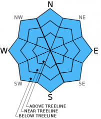
| Mid Slope Winds: | SW | SW | SW |
| Wind Speed: | 15 to 25 mph with gusts to 35 mph. | 20 to 25 mph with gusts to 40 mph, increasing to 30 to 35 mph with gusts to 50 mph after midnight. | 30 to 40 mph with gusts to 60 mph. |
| Expected snowfall: | 0 | 0 | 70% probability 2 to 5 in. / 30% probability 4 to 6 |
For 8000 ft. to 9000 ft.
| Monday | Monday Night | Tuesday | |
|---|---|---|---|
| Weather: | Mostly cloudy skies, becoming partly cloudy. | Partly cloudy skies. | Mostly cloudy skies becoming cloudy. A chance of snow in the morning. Snow in the afternoon. |
| Temperatures: | 36 to 43 deg. F. | 21 to 28 deg. F. | 22 to 29 deg. F. |
| Ridge Top Winds: | SW | SW | SW |
| Wind Speed: | 20 to 30 mph with gusts to 50 mph. | 35 to 40 mph with gusts to 60 mph, increasing to 50 to 55 mph with gusts to 80 mph after midnight. | 55 to 65 mph with gusts to 90 mph. Gusts increasing to 100 mph in the afternoon. |
| Expected snowfall: | 0 | 0 | 70% probability 4 to 6 in. / 30% probability 8 to 12 |


