


For 7000 ft. to 8000 ft.
| Wednesday | Wednesday Night | Thursday | |
|---|---|---|---|
| Weather: | Mostly cloudy then becoming partly cloudy. Isolated snow showers in the morning. | Mostly cloudy then slight chance of snow in the evening. Then chance of snow after midnight. | Cloudy. Snow. |
| Temperatures: | 22 to 29 deg. F. | 17 to 23 deg. F. | 16 to 23 deg. F. |
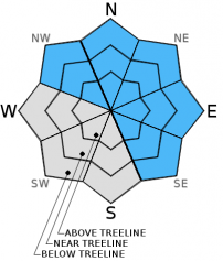
| Mid Slope Winds: | W | W | W |
| Wind Speed: | 15 to 20mph with gusts to 30mph. | 15 to 20mph with gusts to 30mph. | 30 to 40mph with gusts to 60mph. |
| Expected snowfall: | 0 | Up to 1 | 5 to 10 |
For 8000 ft. to 9000 ft.
| Wednesday | Wednesday Night | Thursday | |
|---|---|---|---|
| Weather: | Mostly cloudy becoming partly cloudy. | Mostly cloudy then slight chance of snow in the evening. Then chance of snow after midnight. | Cloudy. Snow |
| Temperatures: | 17 to 24 deg. F. | 14 to 20 deg. F. | 12 to 19 deg. F. |
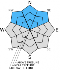
| Ridge Top Winds: | NW | W | SW |
| Wind Speed: | 40 to 50mph with gusts to 75mph. | 30 to 35mph with gusts to 55mph. | 55 to 65mph with gusts to 95mph. |
| Expected snowfall: | 0 | Up to 1 | 5 to 10 |


