THIS AVALANCHE FORECAST EXPIRED ON December 4, 2015 @ 6:55 am
Avalanche Forecast published on December 3, 2015 @ 6:55 am
Issued by Andy Anderson - Tahoe National Forest - Sierra Avalanche Center

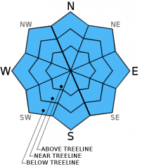
LOW avalanche danger will persist on all aspects and elevations during the day today. Some unstable snow could still exist on isolated terrain features due to the presence of lingering persistent weak layers. The avalanche danger will increase quickly tonight and rise to CONSIDERABLE as new wind slabs and some small storm slabs form overnight. These avalanche problems mean that careful snowpack evaluation, cautious route-finding and conservative decision-making will be essential tomorrow (and tonight).

1. Low

?

Above Treeline
Generally safe avalanche conditions. Watch for unstable snow on isolated terrain features.

1. Low

?

Near Treeline
Generally safe avalanche conditions. Watch for unstable snow on isolated terrain features.

1. Low

?

Below Treeline
Generally safe avalanche conditions. Watch for unstable snow on isolated terrain features.
    Generally safe avalanche conditions. Watch for unstable snow on isolated terrain features.
Avalanche Problem 1: Normal Caution
  • Type ?
  • Aspect/Elevation ?
  • Likelihood ?
    Certain
    Very Likely
    Likely
    Possible
    Unlikely
  • Size ?
    Historic
    Very Large
    Large
    Small

Avalanche activity will remain unlikely during the day today unless the storm arrives much sooner than expected. The avalanche danger will increase quickly once snowfall begins this evening. During the night new fragile wind slabs will form on leeward aspects and some small storm slabs may accumulate above the potential weak layers (facets) that still exist in the bottom half of the snowpack on some NW-N-NE aspects. Knowing where these layers exist now and how weak they currently are can help make more informed decisions when the snowpack becomes deeper tomorrow. The numerous anchors that protrude through these layers have kept them from becoming continuous over large areas and have kept the pockets of instability small and isolated, but these pockets of instability may become more widespread depending on how much snow accumulates tonight. The anchors also make hitting hard immovable objects while traveling through the snow likely in most areas. 

For anyone traveling in the backcountry tonight during the hurricane force winds, heavy snowfall, and utter darkness, human triggered avalanches will be likely. For everyone who waits till tomorrow to get out, the snowpack and avalanche conditions will be very different than today making careful snowpack evaluation, cautious route-finding, and conservative decision-making essential. Careful and informed trip planning tonight and tomorrow morning can help prevent poor decision making caused by "powder fever" and the excitement of early season snow tomorrow.

recent observations

Warmer temperatures and widespread cloud cover caused the snow surface to warm up on all aspects yesterday. Observations from near 10,000 ft. on Red Lake Peak and on Relay Peak both showed moist surface snow and crusts even on northerly aspects. On Red Lake Peak some small wet loose slides occurred on steep south facing slopes and some roller balls occurred on other aspects. Below the surface on Red Lake Peak and Relay Peak, the snowpack consisted of mostly weak layers of faceted snow. Snowpit tests indicated that these layers remain weak but that if they do break, fractures have a hard time traveling along those layers.

These observations match other observations from around the forecast area this week. Many areas have weak layers of faceted snow on the northerly aspects, but tests on these layers only yield obvious unstable results in isolated areas.  

Weather and CURRENT CONDITIONS
weather summary

Increased winds, cloud cover, and warm air moving into the area ahead of a winter storm kept temperatures warm overnight. As the storm approaches today, temperatures should fall while winds and cloud cover should continue to increase. By this afternoon wind speeds along the ridgetops could reach into the 50 to 75 mph range with gusts that exceed 100 mph. Some snow showers may start later today, but the heaviest snowfall should occur between 4 and 10 pm with snow fall rates approaching 1 to 2 inches per hour at times. Snow levels should remain below lake level. The forecast calls for 6 to 12 inches of new snow above 7000 ft tonight. By tomorrow a high pressure ridge should start building over the region bringing an end to the snow and causing the winds to decrease. For more information and details check in with the Reno NWS.

CONDITIONS ALONG THE SIERRA CREST BETWEEN 8200 FT. AND 9200 FT. IN THE LAST 24 HOURS
6am temperature: 35 to 41 deg. F.
Max. temperature: 36 to 44 deg. F.
Average ridgetop wind direction: Southwest
Average ridgetop wind speed: 35 mph
Maximum ridgetop wind gust: 70 mph
New snowfall: 0 inches
Total snow depth: 13 to 20 inches
Two-Day Mountain Weather Forecast Produced in partnership with the Reno NWS
For 7000 ft. to 8000 ft.
Thursday Thursday Night Friday
Weather: Partly cloudy becoming mostly cloudy with a 35% chance of snow after 2 pm Heavy snow between 4 and 10 pm with snow showers decreasing after midnight Mostly cloudy with a 25% chance of snow in the morning
Temperatures: 33 to 40 deg. F. 20 to 25 deg. F. 25 to 32 deg. F.
Mid Slope Winds: South Southwest Southwest
Wind Speed: 10 to 20 mph with gusts to 35 mph increasing to 25 to 40 mph with gusts to 60 mph in the afternoon 25 to 40 mph with gusts to 55 mph decreasing to 15 to 25 mph with gusts to 35 mph after midnight 10 to 20 mph with gusts between 25 and 30 mph
Expected snowfall: up to 1 6 to 12 0
For 8000 ft. to 9000 ft.
Thursday Thursday Night Friday
Weather: Partly cloudy becoming mostly cloudy with a 35% chance of snow after 2 pm Heavy snow between 4 and 10 pm with snow showers decreasing after midnight Mostly cloudy with a 25% chance of snow in the morning
Temperatures: 29 to 36 deg. F. 15 to 20 deg. F. 25 to 31 deg. F.
Ridge Top Winds: South to southwest Southwest Southwest
Wind Speed: 25 to 40 mph with gusts to 60 mph increasing to 50 to 75 mph with gusts between 100 and 115 mph in the afternoon 70 to 75 mph with gusts to 115 mph decreasing to 40 to 45 mph with gusts to 70 mph after midnight 30 to 35 mph with gusts to 50 mph decreasing to 15 to 25 mph with gusts to 35 mph in the afternoon
Expected snowfall: up to 1 6 to 12 0
Disclaimer

This avalanche advisory is provided through a partnership between the Tahoe National Forest and the Sierra Avalanche Center. This advisory covers the Central Sierra Nevada Mountains between Yuba Pass on the north and Ebbetts Pass on the south. Click here for a map of the forecast area. This advisory applies only to backcountry areas outside established ski area boundaries. This advisory describes general avalanche conditions and local variations always occur. This advisory expires 24 hours after the posted time unless otherwise noted. The information in this advisory is provided by the USDA Forest Service who is solely responsible for its content.