THIS AVALANCHE FORECAST EXPIRED ON March 29, 2015 @ 6:58 am
Avalanche Forecast published on March 28, 2015 @ 6:58 am
Issued by Andy Anderson - Tahoe National Forest - Sierra Avalanche Center

Avalanche danger should remain LOW for all elevations and aspects today. Some small loose wet snow instabilities could still occur on some steep slopes today on any aspect where snow cover still exists. While these loose wet snow instabilities should remain minor inconveniences in most places, they could become more problematic near terrain traps (like cliffs) where the terrain can magnify the consequences of any size avalanche.

1. Low

?

Above Treeline
Generally safe avalanche conditions. Watch for unstable snow on isolated terrain features.

1. Low

?

Near Treeline
Generally safe avalanche conditions. Watch for unstable snow on isolated terrain features.

1. Low

?

Below Treeline
Generally safe avalanche conditions. Watch for unstable snow on isolated terrain features.
    Generally safe avalanche conditions. Watch for unstable snow on isolated terrain features.
Avalanche Problem 1: Loose Wet
  • Type ?
  • Aspect/Elevation ?
  • Likelihood ?
    Certain
    Very Likely
    Likely
    Possible
    Unlikely
  • Size ?
    Historic
    Very Large
    Large
    Small

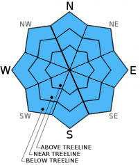
Despite overnight temperatures above freezing, the wet snow that formed yesterday should have all refrozen last night since clear skies allowed the snowpack to radiate heat out into space. This melt-freeze cycle represents the latest in a long series of melt-freeze cycles that have occurred this winter. The repeated melt-freeze cycles mean that any free water that does form in the snowpack can easily drain out of the snow. This well established drainage combined with last night's solid refreeze mean that significant wet snow instabilities remain unlikely today. The lack of snow cover on almost all of the SE-S-SW-W aspects will also limit the formation of troublesome wet snow instabilities since those aspects represent the slopes where the most wet snow typically forms. Some minor roller balls or pinwheels may form on the E and ENE aspects today, and if widespread cloud cover materializes, those minor wet snow instabilities may extend to the NE, N, and NW aspects as well. Any wet snow instabilities that do form today should remain small and not involve enough snow to bury a person, but they could knock a person off balance or push someone off course. In areas near cliffs, rocks, other exposed hazards, or terrain traps these small inconvenient issues could pose more serious problems. 

recent observations

Observations yesterday on Relay Peak revealed conditions consistent with those seen in other areas around the region recently. Sunny east aspects held a few inches of soft wet corn snow resting on top of a supportable melt-freeze crust while northerly aspects and shady east aspects held a mix of wet sticky surface snow that has not fully transitioned to corn and thin frozen melt-freeze crusts. Small inconsequential skier-triggered roller balls and pinwheels represented the only signs of loose wet snow instabilities. Snow cover only existed in a few small isolated areas on the SE-S-SW aspects.

Weather and CURRENT CONDITIONS
weather summary

Even though a weak low pressure system moving through the Pacific Northwest should cause the high pressure ridge over this region to weaken, expect partly cloudy to mostly sunny weather across the forecast area today and tomorrow. The winds should decrease and become light by tonight. The forecast calls for temperatures to remain 10 to 15 degrees above normal with daytime highs in the upper 50's above 7000 ft. today and tomorrow.

CONDITIONS ALONG THE SIERRA CREST BETWEEN 8200 FT. AND 9200 FT. IN THE LAST 24 HOURS
6am temperature: 36 to 42 deg. F.
Max. temperature: 51 to 57 deg. F.
Average ridgetop wind direction: Southwest
Average ridgetop wind speed: 25 to 30 mph
Maximum ridgetop wind gust: 50 mph
New snowfall: 0 inches
Total snow depth: 10 to 38 inches
Two-Day Mountain Weather Forecast Produced in partnership with the Reno NWS
For 7000 ft. to 8000 ft.
Saturday Saturday Night Sunday
Weather: Partly cloudy to mostly sunny Partly cloudy becoming clear Sunny becoming partly cloudy
Temperatures: 52 to 59 deg. F. 26 to 33 deg. F. 53 to 60 deg. F.
Mid Slope Winds: Southwest Variable Variable
Wind Speed: 15 to 20 mph with gusts to 30 mph becoming light in the afternoon Light Light
Expected snowfall: 0 0 0
For 8000 ft. to 9000 ft.
Saturday Saturday Night Sunday
Weather: Partly cloudy to mostly sunny Partly cloudy becoming clear Sunny becoming partly cloudy
Temperatures: 50 to 56 deg. F. 27 to 34 deg. F. 51 to 57 deg. F.
Ridge Top Winds: Southwest shifting to northwest in the afternoon Variable Variable
Wind Speed: 25 to 30 mph with gusts to 45 mph decreasing to 10 to 15 mph with gusts to 25 mph in the afternoon Light Light
Expected snowfall: 0 0 0
Disclaimer

This avalanche advisory is provided through a partnership between the Tahoe National Forest and the Sierra Avalanche Center. This advisory covers the Central Sierra Nevada Mountains between Yuba Pass on the north and Ebbetts Pass on the south. Click here for a map of the forecast area. This advisory applies only to backcountry areas outside established ski area boundaries. This advisory describes general avalanche conditions and local variations always occur. This advisory expires 24 hours after the posted time unless otherwise noted. The information in this advisory is provided by the USDA Forest Service who is solely responsible for its content.