THIS AVALANCHE FORECAST EXPIRED ON December 2, 2016 @ 6:45 am
Avalanche Forecast published on December 1, 2016 @ 6:45 am
Issued by Steve Reynaud - Tahoe National Forest

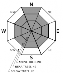
Low avalanche danger exists on all aspects and elevations throughout the forecast area.  Normal caution is advised.  Generally safe avalanche conditions exist.  Watch for unstable snow on isolated terrain features.

1. Low

?

Above Treeline
Generally safe avalanche conditions. Watch for unstable snow on isolated terrain features.

1. Low

?

Near Treeline
Generally safe avalanche conditions. Watch for unstable snow on isolated terrain features.

1. Low

?

Below Treeline
Generally safe avalanche conditions. Watch for unstable snow on isolated terrain features.
    Generally safe avalanche conditions. Watch for unstable snow on isolated terrain features.
Avalanche Problem 1: Normal Caution
  • Type ?
  • Aspect/Elevation ?

Normal caution is advised for travel throughout the forecast region.  Normal caution means exercising proper backcountry travel protocols.  Communicate with your group members about potential unstable snow and terrain options.  Only exposed one member of your group to avalanche terrain at a time.  Re-group out of avalanche terrain and have a travel plan.   

Very isolated wind slabs could be present in near treeline and above treeline terrain.  Over the last several days the winds have shifted many different directions loading most aspects in exposed terrain.  NE winds will increase throughout the day and could form wind slabs on SE-S-SW-W-NW aspects in near treeline and above treeline terrain.  Although the available snow for transport is limited, further scouring of windward aspects could occur with gale force winds.  Watch for blowing snow, cornice formation and wind pillows.

Weak faceted old snow from late October and early November remains buried near the ground above basal ice.  This weak layer is buried 1 to 3 feet deep below the snow surface on North aspects along the northern portion of the Sierra Crest above 8300' and in the Mt. Rose area above 9300'.  This persistent slab problem remains a low likelihood but not impossible situation.

Forecast discussion

The deepest and most usable snowpack within the forecast area exists along the northern portion of the Sierra Crest. Along the Sierra Crest south of Tahoe City, snowpack depths decrease, even at the highest elevations. Recent storms have added to the snowpack in all areas but many rocks and shallowly buried obstacles still exist. The Mount Rose area in the NE portion of the forecast area has decent snowcover, but impact with rocks remains likely at the lower elevations in this area as well.

All of the recent avalanche and snowpack observations submitted by local users have been greatly appreciated and have contributed towards producing the best possible avalanche advisories. Please continue to submit observations through the "submit observations" buttons found throughout this website.

recent observations

Observations were made yesterday on Tamarack Peak in the Mt. Rose area.  Widespread previous wind scouring was observed on N-NE-E aspects above 9300'.  No signs of instability were observed from the recently formed wind slabs.  A snowprofile at 9700' on a north aspect revealed the ongoing issue of faceted snow over basal ice.  Snowpack tests were mixed but overall showed that this weak layer is becoming harder to trigger.  

Weather and CURRENT CONDITIONS
weather summary

Light snow showers will be possible throughout the morning today.  Moderate to strong NE winds today will continue through tonight and Friday increasing in speed.  By Friday, wind chills are forecasted to be near 0F at Lake level with -20F on ridges.  Lake enhanced snow is possible today on the West Shore of Lake Tahoe.  Up to 2'' is forecasted along Hwy. 89, but localized amounts could vary greatly. 

CONDITIONS ALONG THE SIERRA CREST BETWEEN 8200 FT. AND 9200 FT. IN THE LAST 24 HOURS
6am temperature: 17 to 19 deg. F.
Max. temperature: 27 deg. F.
Average ridgetop wind direction: W to NE
Average ridgetop wind speed: 10 to 25 mph
Maximum ridgetop wind gust: 35 mph
New snowfall: Trace to 1 inches
Total snow depth: 12 to 23 inches
Two-Day Mountain Weather Forecast Produced in partnership with the Reno NWS
For 7000 ft. to 8000 ft.
Thursday Thursday Night Friday
Weather: Mostly cloudy becoming partly cloudy this afternoon. Slight chance of snow showers mostly this morning. Clearing Sunny
Temperatures: 25 to 30 deg. F. 14 to 19 deg. F. 24 to 29 deg. F.
Mid Slope Winds: NE NE NE
Wind Speed: 10 to 15mph with gusts to 25mph. 10 to 20mph with gusts to 35mph. 15 to 20mph with gusts to 35mph.
Expected snowfall: Up to 1 0 0
For 8000 ft. to 9000 ft.
Thursday Thursday Night Friday
Weather: Mostly cloudy becoming partly cloudy in the afternoon. Slight chance of snow showers mainly this morning. Clearing Sunny
Temperatures: 20 to 25 deg. F. 10 to 16 deg. F. 20 to 25 deg. F.
Ridge Top Winds: NE NE NE
Wind Speed: 15 to 25mph with gusts to 40mph. 15 to 25mph with gusts to 50mph increasing to 30 to 45mph with gusts to 75mph after midnight. 30 to 50mph with gusts to 95mph.
Expected snowfall: Up to 1 0 0
Disclaimer

This avalanche advisory is provided through a partnership between the Tahoe National Forest and the Sierra Avalanche Center. This advisory covers the Central Sierra Nevada Mountains between Yuba Pass on the north and Ebbetts Pass on the south. Click here for a map of the forecast area. This advisory applies only to backcountry areas outside established ski area boundaries. This advisory describes general avalanche conditions and local variations always occur. This advisory expires 24 hours after the posted time unless otherwise noted. The information in this advisory is provided by the USDA Forest Service who is solely responsible for its content.

For a recorded version of the Avalanche Advisory call (530) 587-3558 x258