THIS AVALANCHE FORECAST EXPIRED ON December 14, 2016 @ 7:00 am
Avalanche Forecast published on December 13, 2016 @ 7:00 am
Issued by Andy Anderson - Tahoe National Forest - Sierra Avalanche Center

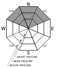
MODERATE avalanche danger exists due to possible persistent slabs on high elevation NW-N-NE aspects on slopes steeper than 32 degrees. While avalanches may have become harder to trigger, large destructive human-triggered avalanches may still be possible today. In addition to the avalanche danger, firm icy slopes may exist on all aspects up to 9000 ft. due to a frozen rain crust.

2. Moderate

?

Above Treeline
Heightened avalanche conditions on specific terrain features. Evaluate snow and terrain carefully; identify features of concern.

2. Moderate

?

Near Treeline
Heightened avalanche conditions on specific terrain features. Evaluate snow and terrain carefully; identify features of concern.

2. Moderate

?

Below Treeline
Heightened avalanche conditions on specific terrain features. Evaluate snow and terrain carefully; identify features of concern.
    Heightened avalanche conditions on specific terrain features. Evaluate snow and terrain carefully; identify features of concern.
Avalanche Problem 1: Persistent Slab
  • Type ?
  • Aspect/Elevation ?
  • Likelihood ?
    Certain
    Very Likely
    Likely
    Possible
    Unlikely
  • Size ?
    Historic
    Very Large
    Large
    Small

Data indicates that the persistent weak layer of weak sugary snow (facets) still exists near the base of the snowpack on N aspects and some NW and NE aspects. Below 9000 ft. on the Sierra Crest triggering a failure on this layer has become unlikely due to the strong thick rain crust on the surface. Above 9000 ft. on the Sierra Crest and in the Mt. Rose area triggering an avalanche on this layer has become more difficult as the upper snowpack has become more supportable. However, a person's weight above a trigger point where a shallower snowpack exists or a larger/deeper trigger could possibly still release a persistent slab avalanche. Trigger points could include areas near rocks or cliffs, areas where a shallow snowpack exists, buried stumps, trees, convex rollovers, and areas where the weak layer is weakest. Large/deep triggers could include cornice failures, multiple people on a slope, stuck snowmobiles, or even boot-packing. Any persistent slab avalanches that occur would have very serious consequences and would likely be unsurvivable. The persistent weak layer now has anywhere from 2 to 4 ft. of snow on top of it that can act as a slab layer. Today's additional 1 to 2 inches of new snow should not add enough weight to change this avalanche problem, but as more snow accumulates tonight it could become easier to trigger.

Due to the consequences associated with the large destructive avalanches that could occur if the persistent weak layer fails and the high degree of uncertainty associated with it, avoiding avalanche terrain where this layer might exist is recommended. These avalanches could connect multiple start zones, could be triggered remotely, and could run farther than expected. When a persistent weak layer like this exists, most informal observations will not provide reliable information about slope stability. Since these avalanches may not fail until someone hits the right spot on the slope, multiple tracks could exist on the slope before it slides. Snowpits can determine if the layer exists and tests can help to see how weak it is, but remember, snowpit work never proves stability, it shows potential signs of instability. Avoiding NW-N-NE aspects steeper than 32 degrees is the simplest strategy for dealing with this persistent weak layer, especially if one has an aversion to or insufficient knowledge of snowpit work.

Forecast discussion

Even though the 1 to 2 inches of new snow predicted to fall above 7000 ft. today should not be enough to change the avalanche danger, the avalanche danger will increase tonight as more snow and wind impact the forecast area. New wind slabs may start to form this afternoon as new snow and wind impact the forecast area. These wind slabs will continue to grow overnight as the bulk of the storm impacts the region and human-triggered wind slabs could become a problem during the night. These wind slabs will be resting on a mix of consolidated snow and frozen ice crusts. In more sheltered areas, new snow resting on icy surfaces could also represent a problem during the night or for tomorrow. Tonight's new snow may also push the persistent slab problem to a deep slab problem as the persistent weak layer gets buried deeper in the snowpacks. Check back for the updated avalanche advisory in the morning before heading out into the backcountry tomorrow. 

recent observations

Yesterday observations from Tamarack Peak and Chickadee Ridge both found that the persistent weak layer still exists near the bottom of the snowpack. The new snow above this layer continues to consolidate. Snowpit tests indicated that this layer has become more difficult to trigger especially where a deeper snowpack exists. However, if this layer does break the resulting fracture can still travel along the persistent weak layer. These observations both came from N aspects above 9000 ft. On Tamarack Peak a semi-supportable rain crust existed on the snow surface up to 9000 to 9200 ft. with cold soft consolidated snow on the surface above that elevation. 

Observations on Castle Peak along the Sierra Crest showed a 6 to 10-inch thick frozen rain crust on all aspects up to at least 8800 ft. and likely up to around 9000 ft. based on the sunlight glinting off the north facing slopes on Donner Peak, Anderson, and Tinkers Knob. Getting force through this ice crust would be as difficult as arresting a fall on it.  

Weather and CURRENT CONDITIONS
weather summary

Clouds should begin to increase today as another storm moves into the region. Snow levels during most of this storm should remain between 7000 and 8200 ft. Precipitation should begin this afternoon with only 1 to 2 inches of new snow expected above 8000 ft and a mix of rain and snow below 8000 ft. Snow and rain should continue through the night with the bulk of the precipitation falling during the night. The forecast calls for another 3 to 6 inches above 8000 ft. tonight with a mix of rain and snow below 8000 ft. and mostly rain below 7000 ft. By tomorrow this round of precipitation should start to taper off. The forecast calls for this storm to focus on areas between Echo Summit and Donner Summit before pushing northward tomorrow. 

CONDITIONS ALONG THE SIERRA CREST BETWEEN 8200 FT. AND 9200 FT. IN THE LAST 24 HOURS
6am temperature: 24 to 31 deg. F.
Max. temperature: 30 to 40 deg. F.
Average ridgetop wind direction: Southwest
Average ridgetop wind speed: 20 mph
Maximum ridgetop wind gust: 42 mph
New snowfall: 0 inches
Total snow depth: Along the Sierra Crest: 14 to 23 inches | In the Mt. Rose area: 44 inches
Two-Day Mountain Weather Forecast Produced in partnership with the Reno NWS
For 7000 ft. to 8000 ft.
Tuesday Tuesday Night Wednesday
Weather: Mostly cloudy with a chance of snow in the morning. Clouds increasing during the day and snow and rain in the afternoon. Snow and rain in the evening. Snow and rain decreasing after midnight. Cloudy with a chance of snow and rain in the morning becoming mostly cloudy with a slight chance of rain and snow in the afternoon.
Temperatures: 34 to 40 deg. F. 30 to 35 deg. F. 43 to 49 deg. F.
Mid Slope Winds: Southwest Southwest Southwest
Wind Speed: 10 to 15 mph with gusts to 35 mph increasing to gusts to 45 mph in the afternoon 15 to 25 mph with gusts to 45 mph 20 to 30 mph with gusts to 55 mph increasing to 70 mph in the afternoon
Expected snowfall: up to 2 2 to 6 up to 1
For 8000 ft. to 9000 ft.
Tuesday Tuesday Night Wednesday
Weather: Mostly cloudy with a chance of snow in the morning. Clouds increasing during the day and snow in the afternoon. Snow in the evening, becoming snow and rain after midnight and decreasing. Cloudy with a chance of snow and rain in the morning becoming mostly cloudy with a slight chance of rain and snow in the afternoon.
Temperatures: 32 to 38 deg. F. 28 to 33 deg. F. 36 to 42 deg. F.
Ridge Top Winds: Southwest Southwest Southwest
Wind Speed: 20 to 30 mph with gusts to 60 mph increasing to gusts to 75 mph in the afternoon 20 to 35 mph with gusts to 75 mph increasing to gusts to 85 mph after midnight 30 to 50 mph with gusts to 90 mph increasing to gusts to 105 mph in the afternoon.
Expected snowfall: 1 to 2 3 to 6 up to 1
Disclaimer

This avalanche advisory is provided through a partnership between the Tahoe National Forest and the Sierra Avalanche Center. This advisory covers the Central Sierra Nevada Mountains between Yuba Pass on the north and Ebbetts Pass on the south. Click here for a map of the forecast area. This advisory applies only to backcountry areas outside established ski area boundaries. This advisory describes general avalanche conditions and local variations always occur. This advisory expires 24 hours after the posted time unless otherwise noted. The information in this advisory is provided by the USDA Forest Service who is solely responsible for its content.

For a recorded version of the Avalanche Advisory call (530) 587-3558 x258