


For 7000 ft. to 8000 ft.
| Thursday | Thursday Night | Friday | |
|---|---|---|---|
| Weather: | Mostly cloudy then becoming cloudy. Chance of rain and snow in the morning, then rain and snow in the afternoon. | Cloudy. Rain and snow. | Mostly cloudy Scattered snow showers. |
| Temperatures: | 43 to 49 deg. F. | 21 to 26 deg. F. | 22 to 27 deg. F. |
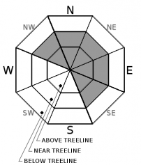
| Mid Slope Winds: | SW | SW | W |
| Wind Speed: | 25 to 45mph. Gusts of 75mph increasing to 90mph in the afternoon. | 20 to 40mph. Gusts up to 75mph decreasing to 65mph after midnight. | 15 to 30mph. Gusts up to 60mph decreasing to 40mph in the afternoon. |
| Expected snowfall: | Up to 3 | 3 to 8 | 1 to 2 |
For 8000 ft. to 9000 ft.
| Thursday | Thursday Night | Friday | |
|---|---|---|---|
| Weather: | Mostly cloudy then becoming cloudy. Chance of rain and snow in the morning, then rain and snow in the afternoon. | Cloudy. Rain and snow. | Mostly cloudy. Scattered snow showers. |
| Temperatures: | 38 to 46 deg. F. | 17 to 22 deg. F. | 18 to 23 deg. F. |
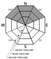
| Ridge Top Winds: | SW | SW | SW shifting to W |
| Wind Speed: | 40 to 65mph. Gusts of 115mph increasing to 125mph in the afternoon. | 40 to 65mph with gusts to 125mph decreasing to 30 to 50mph with gusts to 110mph. | 25 to 45mph with gusts to 95mph shifting to the W at 20 to 30mph with gusts to 75mph. |
| Expected snowfall: | 6 to 12 | 12 to 20 | 1 to 3 |


