THIS AVALANCHE FORECAST EXPIRED ON December 27, 2016 @ 6:59 am
Avalanche Forecast published on December 26, 2016 @ 6:59 am
Issued by Andy Anderson - Tahoe National Forest - Sierra Avalanche Center

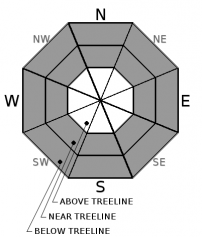
Some human triggered avalanches may remain possible on specific terrain today due to a combination of storm slabs in near and below treeline terrain and lingering wind slabs in wind-loaded near and above treeline terrain. MODERATE avalanche danger exists at all elevations. Evaluate the snowpack and terrain carefully before committing to any slopes.

2. Moderate

?

Above Treeline
Heightened avalanche conditions on specific terrain features. Evaluate snow and terrain carefully; identify features of concern.

2. Moderate

?

Near Treeline
Heightened avalanche conditions on specific terrain features. Evaluate snow and terrain carefully; identify features of concern.

2. Moderate

?

Below Treeline
Heightened avalanche conditions on specific terrain features. Evaluate snow and terrain carefully; identify features of concern.
    Heightened avalanche conditions on specific terrain features. Evaluate snow and terrain carefully; identify features of concern.
Avalanche Problem 1: Storm Slab
  • Type ?
  • Aspect/Elevation ?
  • Likelihood ?
    Certain
    Very Likely
    Likely
    Possible
    Unlikely
  • Size ?
    Historic
    Very Large
    Large
    Small

Human triggered storm slab avalanches may remain possible in some areas today especially where loose weak old snow (near crust facets) exists above the 12/15 rain crust at the base of the recent snow. As the new snow starts to consolidate, it may start to take on more slab-like properties, and this avalanche problem could start to exhibit more persistent slab characteristics in the coming days in areas where the near crust facets exist and remain weak. In some areas, where very little cohesion exists in the new snow or where the near crust facets do not exist or where the new snow has bonded to the snowpack below it, this avalanche problem may no longer be much of a problem. In other areas, some storm slabs may still linger on any aspects in near and below treeline terrain on slopes steeper than 34 degrees where recent snow exists especially on the NW-N-NE-E aspects where these storm slabs are most likely to rest on near crust facets. Some uncertainty exists concerning whether or not these storm slabs may or may not remain active today, but the possibility that they will warrants careful evaluation of the snowpack and terrain before committing to any slope where storm slabs may exist. Avoiding slopes with potential storm slabs by sticking to lower angle slopes or well-anchored slopes can allow for a more fun and safer day recreating on the snow.

Avalanche Problem 2: Wind Slab
  • Type ?
  • Aspect/Elevation ?
  • Likelihood ?
    Certain
    Very Likely
    Likely
    Possible
    Unlikely
  • Size ?
    Historic
    Very Large
    Large
    Small

While triggering a wind slab avalanche should have become more difficult today than yesterday, some human triggered wind slab avalanches may still remain possible on some wind-loaded slopes. Complex and extreme terrain like couloirs, cliffy areas, or unsupported slopes on near and above treeline wind-loaded N-NE-E aspects and the cross-loaded NW and SE aspects represent the best places to find lingering wind slabs today. Some data over the last few days indicates that some wind slabs may have bonded to the old snow, and other data indicates that some have not. In many areas, wind slabs could measure 1.5 to 3 ft in depth with even larger wind slabs on the most wind loaded slopes. If they do break, they could propagate across a slope and could break above the person who triggers them.  

Use clues like cornices, blowing snow, snow drifts, wind pillows, scoured surfaces, ripples in the snow, and other wind created textures to help determine where wind slabs may exist. Use this knowledge to find terrain without wind slabs to recreate on.

recent observations

Yesterday ski cuts and kicks on small above treeline test slopes on Powderhouse Peak did not produce any cracking or other signs of instability. On Castle Peak ski kicks did produce shooting cracks up to 10 ft. long on small wind-loaded test slopes. In both of these areas, little settlement has occurred in the new snow, and it remained soft and unconsolidated. No new avalanches were reported yesterday.

Weather and CURRENT CONDITIONS
weather summary

A calm clear night has left cold air trapped in the valleys. This morning lower elevation sensors reported lows in the single digits and below zero in some places. At the upper elevations, a warming trend has begun. Sensors showed morning lows in the teens and 20's.  The forecast calls for another clear calm day today with highs a few degrees warmer than yesterday. By tonight light southwest winds and a few clouds should return as a system moves into the Pacific Northwest. The light wind, scattered cloud cover, and warmer temperatures should continue into Tuesday with daytime highs reaching into the mid 30's to low 40's above 7000 ft. tomorrow. 

CONDITIONS ALONG THE SIERRA CREST BETWEEN 8200 FT. AND 9200 FT. IN THE LAST 24 HOURS
6am temperature: 13 to 20 deg. F.
Max. temperature: 18 to 24 deg. F.
Average ridgetop wind direction: Variable
Average ridgetop wind speed: 10 mph
Maximum ridgetop wind gust: 22 mph
New snowfall: 0 inches
Total snow depth: Along the Sierra Crest: 28 to 43 inches | In the Mt. Rose area: 59 inches
Two-Day Mountain Weather Forecast Produced in partnership with the Reno NWS
For 7000 ft. to 8000 ft.
Monday Monday Night Tuesday
Weather: Sunny Clear becoming partly cloudy Partly cloudy
Temperatures: 26 to 31 deg. F. 9 to 17 deg. F. 36 to 41 deg. F.
Mid Slope Winds: Variable Variable Variable
Wind Speed: Light Light Light
Expected snowfall: 0 0 0
For 8000 ft. to 9000 ft.
Monday Monday Night Tuesday
Weather: Sunny Clear becoming partly cloudy Partly cloudy
Temperatures: 24 to 29 deg. F. 11 to 16 deg. F. 34 to 39 deg. F.
Ridge Top Winds: Variable Southwest Southwest
Wind Speed: Light Light increasing to 10 to 15 mph with gusts to 30 mph after midnight 10 to 15 mph with gusts to 35 mph
Expected snowfall: 0 0 0
Disclaimer

This avalanche advisory is provided through a partnership between the Tahoe National Forest and the Sierra Avalanche Center. This advisory covers the Central Sierra Nevada Mountains between Yuba Pass on the north and Ebbetts Pass on the south. Click here for a map of the forecast area. This advisory applies only to backcountry areas outside established ski area boundaries. This advisory describes general avalanche conditions and local variations always occur. This advisory expires 24 hours after the posted time unless otherwise noted. The information in this advisory is provided by the USDA Forest Service who is solely responsible for its content.

For a recorded version of the Avalanche Advisory call (530) 587-3558 x258