THIS AVALANCHE FORECAST EXPIRED ON December 30, 2016 @ 6:45 am
Avalanche Forecast published on December 29, 2016 @ 6:45 am
Issued by Steve Reynaud - Tahoe National Forest

Moderate avalanche danger continues throughout the forecast area on slopes steeper than 32 degrees at all elevations due to persistent slabs.  Human triggered avalanches remain possible today.  Evaluate snow and terrain carefully, identify features of concern.

2. Moderate

?

Above Treeline
Heightened avalanche conditions on specific terrain features. Evaluate snow and terrain carefully; identify features of concern.

2. Moderate

?

Near Treeline
Heightened avalanche conditions on specific terrain features. Evaluate snow and terrain carefully; identify features of concern.

2. Moderate

?

Below Treeline
Heightened avalanche conditions on specific terrain features. Evaluate snow and terrain carefully; identify features of concern.
    Heightened avalanche conditions on specific terrain features. Evaluate snow and terrain carefully; identify features of concern.
Avalanche Problem 1: Persistent Slab
  • Type ?
  • Aspect/Elevation ?
  • Likelihood ?
    Certain
    Very Likely
    Likely
    Possible
    Unlikely
  • Size ?
    Historic
    Very Large
    Large
    Small

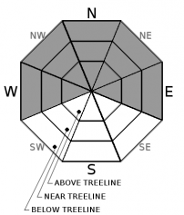
Persistent slabs continue to remain an ongoing avalanche problem around the forecast area.  These persistent slabs may be found on W-NW-N-NE-E aspects below treeline, near treeline, and in some cases above treeline.  Near crust facets that have formed above the Dec. 15 rain crust and below the recent storm snow are the main weak layer in most areas.  Recent avalanches in the last week that have occurred with this persistent slab have frequently been low on the slope in steeper terrain, on convex roll overs, or poorly supported slopes.  Snowpack tests and observations have indicated that this problem is more prevalent along the Sierra Crest than in the Mt. Rose area.

Persistent slab avalanches are unpredictable and require different terrain management techniques.  These avalanches could be triggered low on a slope and away from what we think of as traditional ridgeline wind slab start zones.  Wide propagation is possible into connected terrain.  Use conservative decision making and travel techniques. 


recent observations

Observations yesterday from Tamarack Peak (Mt. Rose area) showed overall good stability.  Snowpack tests targeting the 12/15 near crust facets showed no weakness and signs that propagation was not likely on this layer.  Recent wind loading and scouring had previously occurred throughout this area with wind scoured snow surfaces and wind effected snow in exposed areas.  No reactive wind slab development was found on multiple aspects with snowpack tests and informal observations.

A snow pit was submitted from above Lake Mary (Donner Summit area) at 7300', NW aspect.  Multiple snowpack tests continued to show weakness above the 12/15 rain crust on near crust facets.  An ECT propagated across the column indicating that propagation is likely if you could triggered this weak layer.   

Weather and CURRENT CONDITIONS
weather summary

Above average temperatures will continue for today and into tomorrow with highs in the mid 40's above 7000' with light winds.  Friday night and Saturday there is a chance for light snow showers in the Sierra as low pressure moves through the area with maybe an inch or so possible of snow.  A strong cold front with the possibility of widespread snow returns for early next week.

CONDITIONS ALONG THE SIERRA CREST BETWEEN 8200 FT. AND 9200 FT. IN THE LAST 24 HOURS
6am temperature: 36 to 42 deg. F.
Max. temperature: 48 deg. F.
Average ridgetop wind direction: SW
Average ridgetop wind speed: 5 to 10 mph
Maximum ridgetop wind gust: 18 mph
New snowfall: 0 inches
Total snow depth: Along the Sierra Crest 25 to 39 inches | In the Mt. Rose area 56 inches
Two-Day Mountain Weather Forecast Produced in partnership with the Reno NWS
For 7000 ft. to 8000 ft.
Thursday Thursday Night Friday
Weather: Sunny Clear Partly cloudy.
Temperatures: 42 to 47 deg. F. 20 to 28 deg. F. 37 to 42 deg. F.
Mid Slope Winds: SW
Wind Speed: Light winds. Light winds. Light winds becoming southwest 10 to 15mph with gusts to 35mph in the afternoon.
Expected snowfall: 0 0 0
For 8000 ft. to 9000 ft.
Thursday Thursday Night Friday
Weather: Sunny Clear. Partly cloudy.
Temperatures: 40 to 45 deg. F. 23 to 28 deg. F. 35 to 40 deg. F.
Ridge Top Winds: SW SW SW
Wind Speed: 10 to 15mph with gusts to 25mph in the afternoon. 10 to 15mph with gusts to 30mph. 15 to 25mph with gusts to 45mph.
Expected snowfall: 0 0 0
Disclaimer

This avalanche advisory is provided through a partnership between the Tahoe National Forest and the Sierra Avalanche Center. This advisory covers the Central Sierra Nevada Mountains between Yuba Pass on the north and Ebbetts Pass on the south. Click here for a map of the forecast area. This advisory applies only to backcountry areas outside established ski area boundaries. This advisory describes general avalanche conditions and local variations always occur. This advisory expires 24 hours after the posted time unless otherwise noted. The information in this advisory is provided by the USDA Forest Service who is solely responsible for its content.

For a recorded version of the Avalanche Advisory call (530) 587-3558 x258