THIS AVALANCHE FORECAST EXPIRED ON January 2, 2017 @ 7:00 am
Avalanche Forecast published on December 31, 2016 @ 7:00 am
Issued by Andy Anderson - Tahoe National Forest - Sierra Avalanche Center

THIS ADVISORY WILL BE UPDATED ON JANUARY 2, 2017 at 7:00 am.

Human triggered avalanches will remain possible today and tomorrow on some slopes steeper than 32 degrees. MODERATE avalanche danger exists at all elevations. Evaluate the snowpack and terrain carefully; identify areas where instability may exist, and use this information to avoid those areas of concern. As more snow and wind imapct the region this week the avalanche danger will increase.

2. Moderate

?

Above Treeline
Heightened avalanche conditions on specific terrain features. Evaluate snow and terrain carefully; identify features of concern.

2. Moderate

?

Near Treeline
Heightened avalanche conditions on specific terrain features. Evaluate snow and terrain carefully; identify features of concern.

2. Moderate

?

Below Treeline
Heightened avalanche conditions on specific terrain features. Evaluate snow and terrain carefully; identify features of concern.
    Heightened avalanche conditions on specific terrain features. Evaluate snow and terrain carefully; identify features of concern.
Avalanche Problem 1: Persistent Slab
  • Type ?
  • Aspect/Elevation ?
  • Likelihood ?
    Certain
    Very Likely
    Likely
    Possible
    Unlikely
  • Size ?
    Historic
    Very Large
    Large
    Small

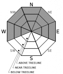
While triggering a persistent slab avalanche has become more difficult in some areas, data and observations indicate that human triggering of persistent slabs may remain possible on some slopes steeper than 32 degrees today and tomorrow. These kind of avalanches would fail at the base of the snow that fell last week on persistent weak layers near the 12/15 rain crust. In most areas near crust facets comprise this weak layer, but some areas may also have a buried surface hoar layer at this interface. Observations have shown the persistent weak layers to exist on W-NW-N-NE-E aspects at all elevations. Data also indicates that these persistent weak layers may remain weakest along the Sierra Crest in areas where a shallower snowpack exists or in areas where the snow above them has become more cohesive and slab-like. A great deal of variability exists concerning how much load these layers can support from slope to slope or even across the same slope. Some slopes may allow for humans to recreate on them without consequence and other slopes may break under the added weight of a person. As new snow provides additional load to the snowpack this week, persistent slab avalanches may become more widespread again. 

Traditional obvious clues may not provide reliable data for persistent slabs. While digging into the snowpack and snowpit tests can reveal whether or not the persistent weak layers exist, an avalanche can sometimes be the first clue that a slope is unstable. Persistent slabs can break after several people have already used slope when one person finds the right trigger point and propagate farther than expected. They can be triggered remotely or low on a slope and away from the more common ridgetop wind slab start zones. In summary, persistent slab avalanches require different terrain management techniques. Use conservative decision making and travel techniques like traveling on low angle or well-anchored slopes or sticking to areas where the persistent weak layers do not exist.  

recent observations

Yesterday observations from Lincoln Ridge (Yuba Pass), Castle Peak (Donner Summit), Silver Peak (North of Squaw), and Granite Chief (NW of Squaw) all found the 12/15 rain crust with facets near it below the snow that fell on 12/23-12/24. Tests targeting the facets in shallower snowpacks on Lincoln Ridge and Silver Peak below 8000 ft. indicated that it remains weak and that if it does break the resulting fracture could propagate along the facet layer. Some tests also indicated that the weight of a person may still be able to cause this layer to break in some places. On Granite Chief, observers saw a thicker layer of snow above the 12/15 facets and rain crust that has become more cohesive and slab-like over the last several days. Tests on low angle slopes in this area also indicated that the facets remained weak. On Castle Peak, tests on the 12/15 facets no longer showed signs of instability.  Overall observations over the last few days across the forecast area have shown a variety of results associated with the 12/15 persistent weak layer with some observations indicating that this weak layer remains weak and sensitive to human triggering and some observations indicating that it has started to adjust to the load above it. Most of the data indicates that it could still represent a problem when additional loading occurs. 

Weather and CURRENT CONDITIONS
weather summary

A small low pressure moving from north to south near the CA coast caused the winds to shift to the east and northeast during the night. These light to moderate winds should continue through today. The forecast calls for some scattered cloud cover and cooler temperatures today. By tonight the winds should shift back to the southwest ahead of a cold low-pressure system expected to arrive over the forecast area Sunday night into Monday. This system will bring colder temperatures and possibly some snow to the region. Snowfall could start as early as Sunday afternoon with very limited accumulation. The bulk of the snowfall should arrive Sunday night and into Monday. The forecast calls for up to 6 inches of new snow by Monday afternoon. Expect daytime highs to get progressively colder over the next few day with tomorrow's temperatures a few degrees colder than today's and Monday's highs more than 10 degrees colder than tomorrow's highs. 

CONDITIONS ALONG THE SIERRA CREST BETWEEN 8200 FT. AND 9200 FT. IN THE LAST 24 HOURS
6am temperature: 21 to 28 deg. F.
Max. temperature: 35 to 45 deg. F.
Average ridgetop wind direction: Southwest shifting to the east and northeast after midnight
Average ridgetop wind speed: 15 to 25 mph
Maximum ridgetop wind gust: 49 mph
New snowfall: 0 inches
Total snow depth: Along the Sierra Crest 25 to 38 inches | In the Mt. Rose area 56 inches
Two-Day Mountain Weather Forecast Produced in partnership with the Reno NWS
For 7000 ft. to 8000 ft.
Saturday Saturday Night Sunday
Weather: Partly cloudy Clear Partly cloudy with clouds increasing during the day. Slight chance (20%) of snow showers in the afternoon.
Temperatures: 32 to 37 deg. F. 16 to 21 deg. F. 29 to 34 deg. F.
Mid Slope Winds: East Southwest Southwest
Wind Speed: 10 mph with gusts to 25 mph in the afternoon 0 to 10 mph increasing to 10 to 15 mph with gusts to 40 mph after midnight 15 to 20 mph increasing to 20 to 30 mph with gusts to 50 mph in the afternoon
Expected snowfall: 0 0 up to 1
For 8000 ft. to 9000 ft.
Saturday Saturday Night Sunday
Weather: Partly cloudy Clear Partly cloudy with clouds increasing during the day. Slight chance (20%) of snow showers in the afternoon.
Temperatures: 31 to 36 deg. F. 16 to 21 deg. F. 28 to 34 deg. F.
Ridge Top Winds: East East shifting to west and southwest after midnight West to southwest
Wind Speed: 10 to 15 mph with gusts to 35 mph 10 to 15 mph with gusts to 30 mph increasing to gusts to 55 mph after midnight 30 to 50 mph with gusts to 85 mph increasing to gusts to 95 mph in the afternoon
Expected snowfall: 0 0 up to 1
Disclaimer

This avalanche advisory is provided through a partnership between the Tahoe National Forest and the Sierra Avalanche Center. This advisory covers the Central Sierra Nevada Mountains between Yuba Pass on the north and Ebbetts Pass on the south. Click here for a map of the forecast area. This advisory applies only to backcountry areas outside established ski area boundaries. This advisory describes general avalanche conditions and local variations always occur. This advisory expires 24 hours after the posted time unless otherwise noted. The information in this advisory is provided by the USDA Forest Service who is solely responsible for its content.

For a recorded version of the Avalanche Advisory call (530) 587-3558 x258