


For 7000 ft. to 8000 ft.
| Thursday | Thursday Night | Friday | |
|---|---|---|---|
| Weather: | Cloudy. Snow changing to rain in the afternoon. | Cloudy. Rain and snow. | Cloudy. Rain likely. |
| Temperatures: | 37 to 42 deg. F. | 31 to 36 deg. F. | 37 to 42 deg. F. |
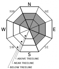
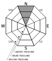
| Mid Slope Winds: | SW | SW | SW |
| Wind Speed: | 10 to 15mph with gusts to 45mph increasing to 20 to 30mph with gusts to 50mph in the afternoon. | 20 to 35mph with gusts to 65mph. | 20 to 30mph. Gusts to 50mph increasing to 65mph in the afternoon. |
| Expected snowfall: | 4 to 6 | 0 | Up to 1 |
For 8000 ft. to 9000 ft.
| Thursday | Thursday Night | Friday | |
|---|---|---|---|
| Weather: | Cloudy. Snow and rain through the day. | Cloudy. Snow and rain. | Cloudy. Snow and rain likely. |
| Temperatures: | 35 to 41 deg. F. | 30 to 35 deg. F. | 34 to 40 deg. F. |
| Ridge Top Winds: | SW | SW | SW |
| Wind Speed: | 30 to 40mph. Gusts up to 70mph increasing to 90mph in the afternoon. | 30 to 40mph with gusts to 90mph. | 30 to 40mph with gusts to 90mph. |
| Expected snowfall: | 4 to 6 | 1 to 3 | Up to 2 |


