


For 7000 ft. to 8000 ft.
| Wednesday | Wednesday Night | Thursday | |
|---|---|---|---|
| Weather: | Cloudy. Snow in the morning, then snow showers in the afternoon. | Cloudy. Snow showers in the evening then isolated snow showers after midnight. | Mostly cloudy then becoming cloudy. Chance of snow in the afternoon. |
| Temperatures: | 27 to 34 deg. F. | 14 to 21 deg. F. | 27 to 34 deg. F. |
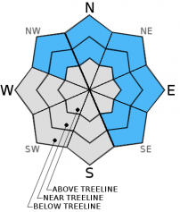
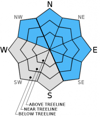
| Mid Slope Winds: | SW | SW | SW |
| Wind Speed: | 35 to 45mph with gusts to 70mph decreasing to 60mph in the afternoon. | 30 to 35mph with gusts to 50mph becoming west 20 to 25mph with gusts to 35mph. | 25 to 35mph with gusts to 50mph. |
| Expected snowfall: | 2 to 6 | Up to 2 | Less than 1 |
For 8000 ft. to 9000 ft.
| Wednesday | Wednesday Night | Thursday | |
|---|---|---|---|
| Weather: | Cloudy. Snow in the morning then snow showers in the afternoon. | Cloudy. Snow showers in the evening then isolated of snow showers after midnight. | Mostly cloudy then becoming cloudy. Slight chance of snow in the afternoon. |
| Temperatures: | 25 to 32 deg. F. | 13 to 20 deg. F. | 25 to 32 deg. F. |
| Ridge Top Winds: | SW | SW | SW |
| Wind Speed: | 60 to 70mph with gusts to 105mph decreasing to 95mph in the afternoon. | 50 to 55mph with gusts to 80mph becoming west and decreasing to 35 to 40mph with gusts to 60mph. | 40 to 50mph with gusts to 70mph increasing to 80mph in the afternoon. |
| Expected snowfall: | 3 to 7 | Up to 2 | Less than 1 |


