


For 7000 ft. to 8000 ft.
| Wednesday | Wednesday Night | Thursday | |
|---|---|---|---|
| Weather: | Partly cloudy. | Partly cloudy. | Sunny |
| Temperatures: | 37 to 44 deg. F. | 20 to 27 deg. F. | 42 to 49 deg. F. |
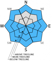
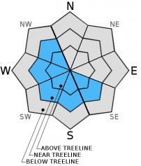
| Mid Slope Winds: | NE | N | W |
| Wind Speed: | 15 to 20mph with gusts to 30mph. | 15 to 20mph with gusts to 30mph in the evening becoming light. | 15 to 20mph with gusts to 30mph. |
| Expected snowfall: | 0 | 0 | 0 |
For 8000 ft. to 9000 ft.
| Wednesday | Wednesday Night | Thursday | |
|---|---|---|---|
| Weather: | Partly cloudy. | Partly cloudy. | Sunny |
| Temperatures: | 34 to 41 deg. F. | 20 to 27 deg. F. | 38 to 45 deg. F. |
| Ridge Top Winds: | NE | N | W |
| Wind Speed: | 15 to 20mph with gusts to 30mph. | 15 to 25mph with gusts to 35mph becoming West 15 to 20mph with gusts to 30mph after midnight. | 15 to 25mph with gusts to 35mph. |
| Expected snowfall: | 0 | 0 | 0 |


