THIS AVALANCHE FORECAST EXPIRED ON April 1, 2016 @ 6:59 am
Avalanche Forecast published on March 31, 2016 @ 6:59 am
Issued by Andy Anderson - Tahoe National Forest - Sierra Avalanche Center

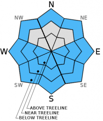
Loose wet avalanches will become possible today due to daytime warming. MODERATE avalanche danger will form on slopes steeper than 35 degrees on E-SE-S-SW-W aspects at all elevations and may form on some  below treeline NW-N-NE aspects. Clues like sinking into wet snow above your boot tops or small point releases, roller balls, or pinwheels can help determine when to move to more frozen aspects, onto lower angle slopes, or to switch to a different afternoon activity.

2. Moderate

?

Above Treeline
Heightened avalanche conditions on specific terrain features. Evaluate snow and terrain carefully; identify features of concern.

2. Moderate

?

Near Treeline
Heightened avalanche conditions on specific terrain features. Evaluate snow and terrain carefully; identify features of concern.

2. Moderate

?

Below Treeline
Heightened avalanche conditions on specific terrain features. Evaluate snow and terrain carefully; identify features of concern.
    Heightened avalanche conditions on specific terrain features. Evaluate snow and terrain carefully; identify features of concern.
Avalanche Problem 1: Loose Wet
  • Type ?
  • Aspect/Elevation ?
  • Likelihood ?
    Certain
    Very Likely
    Likely
    Possible
    Unlikely
  • Size ?
    Historic
    Very Large
    Large
    Small

Since the recent snowfall, today will be the first day of clear skies, all day strong spring sunshine, and daytime highs in the 40's above 7000 ft. These warming factors will all combine to cause rapid warming in the recent snow. This warming will turn the recent snow into unconsolidated wet snow. Below this wet snow, old frozen crusts that make good bed surfaces exist on all aspects. Loose wet snow sitting on top of an efficient bed surface means that loose wet avalanches will be possible today. Some of the loose wet avalanches that occur today could entrain enough snow to cause problems for backcountry travelers especially in areas where the loose wet avalanches involve terrain traps. Slopes steeper than 35 degrees on sun-exposed E-SE-S-SW-W aspects at all elevations will hold the best potential for loose wet avalanches since they should experience the most warming, but some of the below treeline NW-N-NE aspects could also see enough sun for some wet snow instabilities to form.

Sinking into wet snow above your boot tops and small surface instabilities like roller balls, pinwheels, or point releases can provide clues that enough wet snow has formed for larger loose wet avalanches to become an issue. Moving to more frozen slopes or onto lower angle slopes off and away from slopes 35 degrees or steeper before deep wet snow exists on a slope represents a wise choice for today. Terrain traps like gullies, creeks, and cliffs can greatly increase the risk of any size loose wet avalanches.

recent observations

Observations on Relay Peak in the Mt. Rose backcountry showed wind scoured surfaces and exposed frozen crusts on the above treeline exposed NE-N-E aspects. Some minor wind slabs had formed on the W-SW-S aspects but they remained small, did not extend more than 10 ft. down slope, and tests on them did not produce any signs of instabilities. The snow on Relay Peak remained cold and had not experienced any melt-freeze cycles. 

Across the Lake on Donner Peak near Donner Summit, March sunshine had allowed wet surface snow to form on E-SE-S-SW aspects up to at least 8000 ft. and on some N-NE-ENE aspects below about 7800 ft. Many natural loose wet point releases occurred on the east face of Donner Peak near exposed rocks on 3/29 and 3/30. Most of these were relatively small and but some did entrain enough snow to interfere with backcountry travel. Ski cuts on NE-ENE-E-SE facing test slopes also produced loose wet point releases, pinwheels up to 2 ft. in diameter, and ski width wide wet snow sluffs yesterday. 

Weather and CURRENT CONDITIONS
weather summary

The forecast calls for clear, sunny skies and much warmer temperatures today and tomorrow as the high pressure ridge off the west coast moves inland. Expect daytime highs above 7000 ft. to reach the upper 40's today and upper 40's to low 50's tomorrow. The winds should also start to decrease during the next 24 hours becoming light by tomorrow afternoon. 

CONDITIONS ALONG THE SIERRA CREST BETWEEN 8200 FT. AND 9200 FT. IN THE LAST 24 HOURS
6am temperature: 24 to 32 deg. F.
Max. temperature: 33 to 37 deg. F.
Average ridgetop wind direction: East to northeast
Average ridgetop wind speed: 15 to 30 mph
Maximum ridgetop wind gust: 51 mph
New snowfall: On the east side of the Lake: up to 1 inch | Along the Sierra Crest: 0 inches
Total snow depth: 78 to 115 inches
Two-Day Mountain Weather Forecast Produced in partnership with the Reno NWS
For 7000 ft. to 8000 ft.
Thursday Thursday Night Friday
Weather: Sunny Clear Sunny
Temperatures: 44 to 49 deg. F. 25 to 30 deg. F. 48 to 53 deg. F.
Mid Slope Winds: Northeast East East
Wind Speed: 10 to 15 mph with gusts to 30 mph in the morning 10 to 20 mph 10 to 15 mph becoming light in the afternoon
Expected snowfall: 0 0 0
For 8000 ft. to 9000 ft.
Thursday Thursday Night Friday
Weather: Sunny Clear Sunny
Temperatures: 37 to 44 deg. F. 25 to 30 deg. F. 42 to 48 deg. F.
Ridge Top Winds: Northeast North shifting to northeast after midnight Northeast
Wind Speed: 20 to 30 mph with gusts to 50 mph 25 to 30 mph with gusts to 40 mph decreasing to 15 to 20 mph after midnight 15 to 20 mph decreasing to 10 mph in the afternoon
Expected snowfall: 0 0 0
Disclaimer

This avalanche advisory is provided through a partnership between the Tahoe National Forest and the Sierra Avalanche Center. This advisory covers the Central Sierra Nevada Mountains between Yuba Pass on the north and Ebbetts Pass on the south. Click here for a map of the forecast area. This advisory applies only to backcountry areas outside established ski area boundaries. This advisory describes general avalanche conditions and local variations always occur. This advisory expires 24 hours after the posted time unless otherwise noted. The information in this advisory is provided by the USDA Forest Service who is solely responsible for its content.

For a recorded version of the Avalanche Advisory call (530) 587-3558 x258