THIS AVALANCHE FORECAST EXPIRED ON April 2, 2017 @ 7:00 am
Avalanche Forecast published on April 1, 2017 @ 7:00 am
Issued by Andy Anderson - Tahoe National Forest - Sierra Avalanche Center

MODERATE avalanche danger will exist at all elevations today due to lingering wind slab problems and loose wet avalanche problems that form in response to daytime warming. Warming could also weaken the lingering wind slabs in some areas. The largest avalanche problems will exist in areas where more snow accumulated during the recent storm like the Mt. Rose area and other high-elevation areas across the region. Identify where wind slabs and loose wet avalanches may exist and avoid those areas.

2. Moderate

?

Above Treeline
Heightened avalanche conditions on specific terrain features. Evaluate snow and terrain carefully; identify features of concern.

2. Moderate

?

Near Treeline
Heightened avalanche conditions on specific terrain features. Evaluate snow and terrain carefully; identify features of concern.

2. Moderate

?

Below Treeline
Heightened avalanche conditions on specific terrain features. Evaluate snow and terrain carefully; identify features of concern.
    Heightened avalanche conditions on specific terrain features. Evaluate snow and terrain carefully; identify features of concern.
Avalanche Problem 1: Loose Wet
  • Type ?
  • Aspect/Elevation ?
  • Likelihood ?
    Certain
    Very Likely
    Likely
    Possible
    Unlikely
  • Size ?
    Historic
    Very Large
    Large
    Small

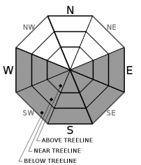
The intense spring sunshine and warm daytime temperatures should cause enough melting for some loose wet avalanches to become possible today especially in areas where storm snow from Wednesday and Thursday exists on the surface. As the sun and warm temperatures heat this snow up, it will warm up for the first time and will become wet and weak. Sun-exposed E-SE-S-SW-W slopes in the Mt Rose area and in other higher-elevation areas across the region hold the best potential for loose wet avalanches since more recent snow exists in those areas. Loose wet avalanches could also occur in areas where the sun and warmth melt through the exposed surface crusts and leave areas of deep wet snow on the slopes.

Avalanche Problem 2: Wind Slab
  • Type ?
  • Aspect/Elevation ?
  • Likelihood ?
    Certain
    Very Likely
    Likely
    Possible
    Unlikely
  • Size ?
    Historic
    Very Large
    Large
    Small

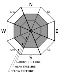
Wind slabs that formed during the storm still exist on wind-loaded and cross-loaded slopes. The largest of these wind slabs exist in near and above treeline terrain on wind-loaded W-SW-S aspects and cross-loaded NW and SE aspects in the Mt. Rose area and in other isolated high-elevation areas across the region where the most snow accumulated during the storm. Observations from yesterday indicated that some wind slabs also exist on cross-loaded N-NE-E aspects. Human triggered wind slabs may remain possible today. Most of these should remain small and not extend very far away from the ridgelines, but a few larger wind slabs could exist in isolated areas where the most snow fell. The most fragile wind slabs will exist on sun-exposed aspects where sun and daytime warming will weaken the wind slabs. Along the Sierra Crest where less storm snow accumulated, wind slabs should remain smaller and less likely to represent a significant avalanche problem.


recent observations

Yesterday a snowboarder triggered avalanche was reported on an above treeline E aspect on Relay Peak. This avalanche measured about 1 ft in depth and 150 ft. in width. It appears that this wind slab had formed on a cross-loaded E aspect above a small cliff band. No injuries were reported. On Inline Lake Peak, wind slabs up to 16 inches in depth had formed on wind-loaded SW aspects. Ski kicks on these wind slabs triggered shooting cracks and some small test slope failures. Snow surface conditions varied from scoured icy crusts to wind packed surfaces in most areas. A few small areas of soft unconsolidated snow still existed on low angle slopes in below treeline areas sheltered from the wind. Observations on Jakes Peak found much less new snow and more exposed icy crusts. Surface conditions alternated between refrozen old snow and dust on crust conditions where new snow had accumulated. Some small wind slabs up to 4 inches deep did exist on NE aspects near the summit of Jakes. 

Weather and CURRENT CONDITIONS
weather summary

A high-pressure ridge over the region will allow temperatures to climb into mid to upper 40's above 7000 ft. today under clear sunny skies. The east and northeast winds should begin to decrease with light winds expected in many areas by this afternoon. Some cloud cover could begin to form over the forecast area tonight ahead of two weak disturbances passing by the region tomorrow and tomorrow night. These weak systems may bring a slight chance of light showers to the area tomorrow afternoon and during the night. Precipitation amounts should remain small.

CONDITIONS ALONG THE SIERRA CREST BETWEEN 8200 FT. AND 9200 FT. IN THE LAST 24 HOURS
6am temperature: 25 to 32 deg. F.
Max. temperature: 33 to 36 deg. F.
Average ridgetop wind direction: East and northeast
Average ridgetop wind speed: 40 to 55 mph
Maximum ridgetop wind gust: 109 mph
New snowfall: 0 inches
Total snow depth: 120 to 175 inches
Two-Day Mountain Weather Forecast Produced in partnership with the Reno NWS
For 7000 ft. to 8000 ft.
Saturday Saturday Night Sunday
Weather: Sunny Partly cloudy Partly cloudy with a slight chance of showers in the afternoon
Temperatures: 42 to 48 deg. F. 27 to 33 deg. F. 40 to 46 deg. F.
Mid Slope Winds: East Variable Variable
Wind Speed: 10 to 15 mph with gusts to 30 mph decreasing to light winds in the afternoon Light Light
Expected snowfall: 0 0 0
For 8000 ft. to 9000 ft.
Saturday Saturday Night Sunday
Weather: Sunny Partly cloudy Partly cloudy with a slight chance of showers in the afternoon
Temperatures: 39 to 45 deg. F. 28 to 33 deg. F. 37 to 43 deg. F.
Ridge Top Winds: East Variable Northwest
Wind Speed: 20 to 35 mph with gusts to 65 mph this morning decreasing to 15 to 25 mph with gusts to 45 mph in the afternoon Light 10 to 15 mph with gusts to 35 mph
Expected snowfall: 0 0 0
Disclaimer

This avalanche advisory is provided through a partnership between the Tahoe National Forest and the Sierra Avalanche Center. This advisory covers the Central Sierra Nevada Mountains between Yuba Pass on the north and Ebbetts Pass on the south. Click here for a map of the forecast area. This advisory applies only to backcountry areas outside established ski area boundaries. This advisory describes general avalanche conditions and local variations always occur. This advisory expires 24 hours after the posted time unless otherwise noted. The information in this advisory is provided by the USDA Forest Service who is solely responsible for its content.

For a recorded version of the Avalanche Advisory call (530) 587-3558 x258