THIS AVALANCHE FORECAST EXPIRED ON April 21, 2017 @ 6:24 am
Avalanche Forecast published on April 20, 2017 @ 6:24 am
Issued by Andy Anderson - Tahoe National Forest - Sierra Avalanche Center

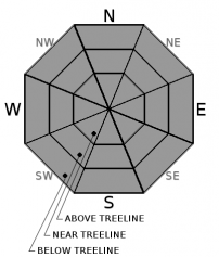
MODERATE avalanche danger exists today due to lingering wind slabs and loose wet avalanche problems that will form as the sun comes out and the day warms up. This afternoon's sunshine and warming may also weaken the lingering wind slabs. Human-triggered avalanches large enough to cause problems for backcountry travelers are possible today. Wet slab avalanches should remain unlikely today, but they are not impossible. Avoid slopes where wet snow or wind slabs exist.

2. Moderate

?

Above Treeline
Heightened avalanche conditions on specific terrain features. Evaluate snow and terrain carefully; identify features of concern.

2. Moderate

?

Near Treeline
Heightened avalanche conditions on specific terrain features. Evaluate snow and terrain carefully; identify features of concern.

2. Moderate

?

Below Treeline
Heightened avalanche conditions on specific terrain features. Evaluate snow and terrain carefully; identify features of concern.
    Heightened avalanche conditions on specific terrain features. Evaluate snow and terrain carefully; identify features of concern.
Avalanche Problem 1: Loose Wet
  • Type ?
  • Aspect/Elevation ?
  • Likelihood ?
    Certain
    Very Likely
    Likely
    Possible
    Unlikely
  • Size ?
    Historic
    Very Large
    Large
    Small

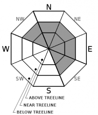
Despite slightly cooler temperatures and breezy weather today, the strong April sunshine and daytime highs above freezing should provide enough warming for loose wet avalanches to become possible again today. The new snow from last night and this morning and the storm snow from Monday night that has not fully transitioned to corn could easily become wet and slushy this afternoon and loose wet avalanches could entrain all of this snow. Human-triggered loose wet avalanche activity will become possible on any slopes that receive sunshine today especially on those slopes where the most new snow exists. Loose wet avalanches should comprise the majority of the wet snow issues today, but some isolated wet slab avalanches are not impossible in sun-exposed areas on any aspects/slopes that hold more than a few inches of new snow.

Avoid slopes where signs of rapid warming like sticky wet surface snow, roller balls, pinwheels, or other signs of wet snow exist. Once the sun hits the slopes today, the snow may become unstable and less fun to recreate on. Seek out shaded, sheltered slopes where the snow remains cold and non-wind-affected for better and safer recreation.

Avalanche Problem 2: Wind Slab
  • Type ?
  • Aspect/Elevation ?
  • Likelihood ?
    Certain
    Very Likely
    Likely
    Possible
    Unlikely
  • Size ?
    Historic
    Very Large
    Large
    Small

Fragile wind slabs and cornices may still linger on or above wind-loaded N-NE-E aspects as well as on cross-loaded NW and SE aspects in near and above treeline terrain. Human-triggered wind slab avalanches remain possible today and could involve enough snow to bury or injure a person. The largest and most fragile wind slabs will exist in areas where the most new snow has accumulated. As the sun comes back out this afternoon, rapid warming could also weaken the bonds holding these wind slabs and cornices in place and make them more fragile and easier to trigger.

Clues like cornices above slopes, drifted snow, ripples in the snow surface, and other wind created textures can help identify where fragile wind slabs may exist. Use this information to avoid the wind slabs and to find sheltered non-wind-affected snow to travel on.

recent observations

Yesterday observations from Negro Canyon, Granite Chief, and Ralston Peak all found easy-to-trigger loose wet instabilities on sunny slopes. On Ralston and Granite Chief where more new snow existed, the loose wet instabilities entrained more snow. Avalanche activity that likely occurred on Tuesday afternoon also existed in all three areas in the form of large cornice failures and large loose wet avalanches on Granite Chief, in Negro Canyon, and on Donner Peak. A wind slab avalanche had occurred on Ralston as well. Observations targeting the wind slab issue on Ralston yesterday show ongoing wind transport and wind slab formation as well as lingering instability associated with the wind slabs

Weather and CURRENT CONDITIONS
weather summary

A low pressure moving over northern CA has brought some snow showers to the area. Accumulations have remained light with some remote sensors reporting up to an inch of new snow. Another inch or maybe two could fall this morning before snow showers come to an end today as this system moves farther away. Cloud cover and winds should also diminish, but temperatures should remain cooler with daytime highs in the upper 30's and low 40's above 7000 ft. A high-pressure ridge should move into the area bringing some E, NE, and SE winds during the night and tomorrow along the ridgelines. This high-pressure will also bring sunny skies and much warmer temperatures for tomorrow. Expect daytime highs in the upper 40's to low 50's above 7000 ft. tomorrow. 

CONDITIONS ALONG THE SIERRA CREST BETWEEN 8200 FT. AND 9200 FT. IN THE LAST 24 HOURS
6am temperature: 24 to 30 deg. F.
Max. temperature: 37 to 44 deg. F.
Average ridgetop wind direction: Southwest
Average ridgetop wind speed: 25 to 35 mph
Maximum ridgetop wind gust: 114 mph
New snowfall: 0 to 1 inches
Total snow depth: 127 to 193 inches
Two-Day Mountain Weather Forecast Produced in partnership with the Reno NWS
For 7000 ft. to 8000 ft.
Thursday Thursday Night Friday
Weather: Mostly cloudy with isolated snow showers in the morning becoming sunny in the afternoon Clear becoming partly cloudy Sunny
Temperatures: 38 to 45 deg. F. 25 to 30 deg. F. 48 to 55 deg. F.
Mid Slope Winds: Southwest Variable Variable
Wind Speed: 10 to 20 mph with gusts to 35 mph in the morning Light Light
Expected snowfall: up to 1 0 0
For 8000 ft. to 9000 ft.
Thursday Thursday Night Friday
Weather: Mostly cloudy with isolated snow showers in the morning becoming sunny in the afternoon Clear becoming partly cloudy Sunny
Temperatures: 30 to 38 deg. F. 24 to 29 deg. F. 41 to 48 deg. F.
Ridge Top Winds: Southwest shifting to the west in the afternoon Northwest shifting to the east after midnight Southeast
Wind Speed: 30 to 50 mph with gusts to 70 mph decreasing to 15 to 25 mph with gusts to 40 mph in the afternoon 10 to 15 mph increasing to 15 to 25 mph with gusts to 40 mph after midnight 10 to 15 mph with gusts to 35 mph
Expected snowfall: up to 1 0 0
Disclaimer

This avalanche advisory is provided through a partnership between the Tahoe National Forest and the Sierra Avalanche Center. This advisory covers the Central Sierra Nevada Mountains between Yuba Pass on the north and Ebbetts Pass on the south. Click here for a map of the forecast area. This advisory applies only to backcountry areas outside established ski area boundaries. This advisory describes general avalanche conditions and local variations always occur. This advisory expires 24 hours after the posted time unless otherwise noted. The information in this advisory is provided by the USDA Forest Service who is solely responsible for its content.

For a recorded version of the Avalanche Advisory call (530) 587-3558 x258