THIS AVALANCHE FORECAST EXPIRED ON April 22, 2017 @ 6:59 am
Avalanche Forecast published on April 21, 2017 @ 6:59 am
Issued by Andy Anderson - Tahoe National Forest - Sierra Avalanche Center

LOW avalanche danger this morning will rise to MODERATE avalanche danger as the day warms up. Loose wet avalanches will become possible again today on slopes where wet snow forms. While triggering a wind slab has become unlikely except in a few isolated places, cornice failures remain possible today especially as warming weakens the cornices. Avoid slopes where wet, unsupportable snow exists and complex or extreme terrain where isolated wind slabs may exist. Give all cornices a wide berth.  

2. Moderate

?

Above Treeline
Heightened avalanche conditions on specific terrain features. Evaluate snow and terrain carefully; identify features of concern.

2. Moderate

?

Near Treeline
Heightened avalanche conditions on specific terrain features. Evaluate snow and terrain carefully; identify features of concern.

2. Moderate

?

Below Treeline
Heightened avalanche conditions on specific terrain features. Evaluate snow and terrain carefully; identify features of concern.
    Heightened avalanche conditions on specific terrain features. Evaluate snow and terrain carefully; identify features of concern.
Avalanche Problem 1: Loose Wet
  • Type ?
  • Aspect/Elevation ?
  • Likelihood ?
    Certain
    Very Likely
    Likely
    Possible
    Unlikely
  • Size ?
    Historic
    Very Large
    Large
    Small

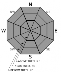
Sunny skies and warm daytime temperatures should provide sufficient warming to melt through last night's refreeze. Once this refreeze melts, loose wet avalanches will become possible on steep slopes. Some of these loose wet avalanches could still entrain enough snow to cause problems for backcountry travelers especially if they occur in an area where terrain traps like gullies, creeks, or cliffs could magnify the consequences of an avalanche. The sun-exposed E-SE-S-SW-W aspects hold the best potential for loose wet avalanches today, but enough warming could occur for some loose wet problems to also exist on some northerly aspects. Loose wet avalanches should comprise the majority of the wet snow issues today, but some isolated wet slab avalanches are not impossible in sun-exposed areas on any aspects/slopes where the recent snow has not been through a significant melt-freeze cycle.

Sinking into boot-top deep wet snow, roller balls, pinwheels, or other signs unsupportable wet snow can represent clues that loose wet avalanches have become possible and that the snow has likely become less fun to recreate on. Get out early and find slopes with only a couple inches of wet surface snow and a supportable refrozen crust below for better and safer recreation. Once the snow starts to become wet and unsupportable, move to a colder aspect or head down and enjoy the spring afternoon in other ways. 

Avalanche Problem 2: Cornice
  • Type ?
  • Aspect/Elevation ?
  • Likelihood ?
    Certain
    Very Likely
    Likely
    Possible
    Unlikely
  • Size ?
    Historic
    Very Large
    Large
    Small

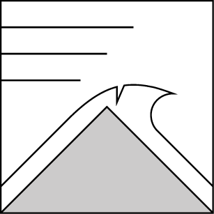
The large cornices above many wind-loaded slopes will remain fragile today and cornice failures are possible. The sun and warm temperatures will make these cornices even weaker as the day warms up. Give these cornices a wide berth and stay well back from their edges. 

Avalanche Problem 3: Wind Slab
  • Type ?
  • Aspect/Elevation ?
  • Likelihood ?
    Certain
    Very Likely
    Likely
    Possible
    Unlikely
  • Size ?
    Historic
    Very Large
    Large
    Small

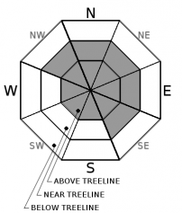
Triggering a lingering wind-slab avalanche should be unlikely in most places today, and the light easterly winds combined with a lack of available snow means that new winds slabs are also unlikely today. However, unlikely does not mean impossible and some isolated wind slab instabilities may exist in some places. High elevation wind-loaded slopes, couloirs, gullies, unsupported slopes, and other complex or extreme terrain represent the best places to find one of these isolated wind slabs.

Forecast discussion

The last advisory of the season will occur April 23rd. Thanks to all who have supported the avalanche center. Click here for more information regarding the scheduled end date.

recent observations

Yesterday we received a report of a human-triggered cornice failure on the north side of Castle Peak. No other observations or data came in from yesterday. Recent observations from Tues. and Wed. showed the storm snow starting to transition towards corn snow, but it had not been through enough melt-freeze cycles to fully transition as of Wed. afternoon. Observations from Wed. also revealed that the sun and warmth can quickly melt through the overnight refreezes with the snow becoming wet and unsupportable in places by mid-day.

Weather and CURRENT CONDITIONS
weather summary

A high-pressure ridge will bring spring-like weather to the forecast area today and tomorrow. The forecast calls for light easterly winds and sunny skies today with daytime highs about 10 degrees warmer than yesterday. Temperatures could climb into the upper 40's to low 50's above 7000 ft. The winds should shift to the southwest and increase some tomorrow due to a low-pressure trough heading for the Pacific NW. Those increased winds will help bring even warmer air to the region and daytime highs could climb into the low to upper 50's above 7000 ft. tomorrow. 

CONDITIONS ALONG THE SIERRA CREST BETWEEN 8200 FT. AND 9200 FT. IN THE LAST 24 HOURS
6am temperature: 26 to 32 deg. F.
Max. temperature: 36 to 45 deg. F.
Average ridgetop wind direction: SW shifting to NE during the night
Average ridgetop wind speed: 15 to 25 mph
Maximum ridgetop wind gust: 53 mph
New snowfall: 0 inches
Total snow depth: 126 to 192 inches
Two-Day Mountain Weather Forecast Produced in partnership with the Reno NWS
For 7000 ft. to 8000 ft.
Friday Friday Night Saturday
Weather: Sunny Clear Sunny becoming partly cloudy in the afternoon
Temperatures: 48 to 56 deg. F. 31 to 36 deg. F. 53 to 59 deg. F.
Mid Slope Winds: East and southeast Variable Southwest
Wind Speed: up to 10 mph Light Light
Expected snowfall: 0 0 0
For 8000 ft. to 9000 ft.
Friday Friday Night Saturday
Weather: Sunny Clear Sunny becoming partly cloudy
Temperatures: 40 to 48 deg. F. 32 to 37 deg. F. 43 to 53 deg. F.
Ridge Top Winds: East to southeast Southwest Southwest
Wind Speed: 10 to 15 mph with gusts to 25 mph in the morning 10 to 15 mph with gusts to 30 mph after midnight 15 to 20 mph with gusts to 50 mph increasing to 25 to 35 mph with gusts to 70 mph in the afternoon
Expected snowfall: 0 0 0
Disclaimer

This avalanche advisory is provided through a partnership between the Tahoe National Forest and the Sierra Avalanche Center. This advisory covers the Central Sierra Nevada Mountains between Yuba Pass on the north and Ebbetts Pass on the south. Click here for a map of the forecast area. This advisory applies only to backcountry areas outside established ski area boundaries. This advisory describes general avalanche conditions and local variations always occur. This advisory expires 24 hours after the posted time unless otherwise noted. The information in this advisory is provided by the USDA Forest Service who is solely responsible for its content.

For a recorded version of the Avalanche Advisory call (530) 587-3558 x258