THIS AVALANCHE FORECAST EXPIRED ON February 14, 2017 @ 6:45 am
Avalanche Forecast published on February 13, 2017 @ 6:45 am
Issued by Steve Reynaud - Tahoe National Forest

Moderate avalanche danger exists in below treeline, near treeline, and above treeline terrain due to loose wet and wind slab avalanches.  Loose wet avalanches are possible at all elevations and human triggered wind slabs are becoming unlikely but not impossible in near and above treeline terrain.  Evaluate snow and terrain carefully, identify areas of concern. 

2. Moderate

?

Above Treeline
Heightened avalanche conditions on specific terrain features. Evaluate snow and terrain carefully; identify features of concern.

2. Moderate

?

Near Treeline
Heightened avalanche conditions on specific terrain features. Evaluate snow and terrain carefully; identify features of concern.

2. Moderate

?

Below Treeline
Heightened avalanche conditions on specific terrain features. Evaluate snow and terrain carefully; identify features of concern.
    Heightened avalanche conditions on specific terrain features. Evaluate snow and terrain carefully; identify features of concern.
Avalanche Problem 1: Loose Wet
  • Type ?
  • Aspect/Elevation ?
  • Likelihood ?
    Certain
    Very Likely
    Likely
    Possible
    Unlikely
  • Size ?
    Historic
    Very Large
    Large
    Small

Loose wet avalanches are possible in below treeline terrain on all aspects and on SE-S-SW aspects at all elevations as daytime warming increases today and winds diminish.  Most of these loose wet avalanches should be in the form of roller balls but some could be larger and involve enough snow to injure a backcountry user.  As rapid warming occurs later this morning, look for active roller balls and deep unsupportable snow.  Avoid steep slopes where unstable snow exists.

Avalanche Problem 2: Wind Slab
  • Type ?
  • Aspect/Elevation ?
  • Likelihood ?
    Certain
    Very Likely
    Likely
    Possible
    Unlikely
  • Size ?
    Historic
    Very Large
    Large
    Small

Wind slabs are becoming unlikely but not impossible on SE-S-SW-W-NW-N aspects in near and above treeline terrain.  In most areas there is limited snow available for transport and the NE/E winds have diminished in speed.  Lingering wind slabs could still exist in isolated areas.  Look for clues that previous wind loading has occurred and avoid steep wind loaded terrain.  Large cornices exist along most ridgelines and extra caution is advised around these hazards.


recent observations

Observations were made and received from Blue Lakes (Carson Pass area), Rose Knob Peak (Mt. Rose area), Andesite Peak (Donner Summit area), Shirley Canyon (Squaw Valley area), and the Backcountry outside of Bear Valley Ski Resort.  A boarder triggered avalanche was reported on Rose Knob yesterday that caught 1 backcountry user.  The slide was reported to be 30' wide and ran for 500' downslope with a 1' crown.  In most areas, loose wet avalanche activity was reported in the form of roller balls on steep solar aspects in the mid day hours with some larger loose wet avalanches reported.  Snow surface conditions were reported as variable with everything from wet surface snow, breakable crusts, and supportable wind board.   

Weather and CURRENT CONDITIONS
weather summary

Warmer and dry weather will continue through Wednesday.  NE flow today should be light to moderate in speed and be limited to the highest elevations.  The next storm is forecasted to arrive on Thursday and is expected to be the first in a series of storms that impact our area.

CONDITIONS ALONG THE SIERRA CREST BETWEEN 8200 FT. AND 9200 FT. IN THE LAST 24 HOURS
6am temperature: 21 to 32 deg. F.
Max. temperature: 38 deg. F.
Average ridgetop wind direction: NE/E
Average ridgetop wind speed: 25 to 30 mph
Maximum ridgetop wind gust: 36 mph
New snowfall: 0 inches
Total snow depth: 122 to 144 inches
Two-Day Mountain Weather Forecast Produced in partnership with the Reno NWS
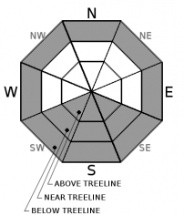
For 7000 ft. to 8000 ft.
Monday Monday Night Tuesday
Weather: Partly cloudy. Mostly cloudy. Mostly cloudy then becoming partly cloudy.
Temperatures: 41 to 46 deg. F. 22 to 28 deg. F. 43 to 48 deg. F.
Mid Slope Winds:
Wind Speed: Light winds. Light winds. Light winds.
Expected snowfall: 0 0 0
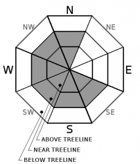
For 8000 ft. to 9000 ft.
Monday Monday Night Tuesday
Weather: Partly cloudy. Mostly cloudy. Mostly cloudy then becoming partly cloudy.
Temperatures: 41 to 46 deg. F. 24 to 29 deg. F. 42 to 47 deg. F.
Ridge Top Winds:
Wind Speed: Light winds. Light winds. Light winds.
Expected snowfall: 0 0 0
Disclaimer

This avalanche advisory is provided through a partnership between the Tahoe National Forest and the Sierra Avalanche Center. This advisory covers the Central Sierra Nevada Mountains between Yuba Pass on the north and Ebbetts Pass on the south. Click here for a map of the forecast area. This advisory applies only to backcountry areas outside established ski area boundaries. This advisory describes general avalanche conditions and local variations always occur. This advisory expires 24 hours after the posted time unless otherwise noted. The information in this advisory is provided by the USDA Forest Service who is solely responsible for its content.

For a recorded version of the Avalanche Advisory call (530) 587-3558 x258