THIS AVALANCHE FORECAST EXPIRED ON February 18, 2017 @ 6:59 am
Avalanche Forecast published on February 17, 2017 @ 6:59 am
Issued by Andy Anderson - Tahoe National Forest - Sierra Avalanche Center

Human-triggered wind slab avalanches will be possible today on wind-loaded slopes. Near and above treeline terrain will hold more widespread and larger wind slabs, but some wind slabs may still linger in below treeline terrain. MODERATE avalanche danger exists at all elevations. Due to unusual wind directions, wind slabs may exist in unusual places. Evaluate the snowpack and terrain carefully to identify where avalanche problems may exist and plan travel routes to avoid them.

2. Moderate

?

Above Treeline
Heightened avalanche conditions on specific terrain features. Evaluate snow and terrain carefully; identify features of concern.

2. Moderate

?

Near Treeline
Heightened avalanche conditions on specific terrain features. Evaluate snow and terrain carefully; identify features of concern.

2. Moderate

?

Below Treeline
Heightened avalanche conditions on specific terrain features. Evaluate snow and terrain carefully; identify features of concern.
    Heightened avalanche conditions on specific terrain features. Evaluate snow and terrain carefully; identify features of concern.
Avalanche Problem 1: Wind Slab
  • Type ?
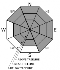
  • Aspect/Elevation ?
  • Likelihood ?
    Certain
    Very Likely
    Likely
    Possible
    Unlikely
  • Size ?
    Historic
    Very Large
    Large
    Small

Continued wind and additional snowfall today will lead to another round of wind slab formation on wind-loaded slopes. The forecasted SE winds are uncommon for this area, so wind slabs will likely exist in unusual places today with direct wind-loading occurring on W-NW-N aspects and cross-loading on SW and NE aspects. Some of the wind slabs that formed yesterday will still linger on previously wind-loaded NW-N-NE-E-SE aspects, and the new wind slabs could form on top of these in some places. Human-triggered wind slabs will be possible today on all aspects in near and above treeline terrain due to the shifting winds and unusual wind directions. Some of these wind slabs may be firm and stubborn, and some could break above the person who triggers them. Some smaller wind slabs may still remain in below treeline terrain as well due to the strength of the wind over the last 24 hours. 

Identify where wind slabs may exist using clues like blowing snow, cornices, wind pillows, ripples across a slope, firm but hollow sounding snow, and other wind created textures. Use this information to plan a route that avoids the wind slabs and utilizes more sheltered terrain where better snow for recreation will exist.

recent observations

Yesterday observations on Andesite Ridge and Ophir Peak revealed significant wind-loading despite the limited snow accumulation. Wind slabs on Ophir Peak measured up to 8 inches in depth, and on Andesite, they grew to 14 inches in the most heavily wind-loaded areas. On Ophir Peak ski cuts and kicks on wind-loaded test slopes did not produce signs of instability, and data and observations indicated good bonding between the old and new snow. Across the Lake on Andesite Peak, refrigerator-sized cornice pieces dropped onto a test slope caused a wind slab failure that propagated a few feet wider than the cornice pieces. Ski cuts could trigger cracking on wind-loaded test slopes on Andesite Peak if those slopes were undercut first. In both areas, gale force southwest winds continued wind-loading slopes all day. 

Weather and CURRENT CONDITIONS
weather summary

After dropping 2 to 5 inches of snow onto the forecast area above 6500 ft, the first storm in this series departed yesterday afternoon and evening. The gale force southwest winds started decreasing yesterday afternoon and continued to diminish through the night. The winds remain in the 15 to 30 mph range this morning, and they have started to shift to the southeast. The second storm in this series should arrive today. The bulk of this storm will remain south of the forecast area, but enough moisture will push north to bring another 3 to 7 inches of snow during the day today and 2 to 5 more inches tonight. Winds will remain in the moderate range and continue to blow from the southeast. By tomorrow this storm should begin winding down, and the winds should shift back to the southwest ahead of another small storm. Another large winter storm remains on track to impact the forecast area starting Sunday night and Monday morning. Check in with the Reno NWS for more details.

CONDITIONS ALONG THE SIERRA CREST BETWEEN 8200 FT. AND 9200 FT. IN THE LAST 24 HOURS
6am temperature: 25 to 29 deg. F.
Max. temperature: 35 to 39 deg. F.
Average ridgetop wind direction: Southwest
Average ridgetop wind speed: 20 to 30 mph
Maximum ridgetop wind gust: 121 mph
New snowfall: 2 to 5 inches
Total snow depth: 115 to 137 inches
Two-Day Mountain Weather Forecast Produced in partnership with the Reno NWS
For 7000 ft. to 8000 ft.
Friday Friday Night Saturday
Weather: Cloudy with snow likely in the morning snow becoming more widespread in the afternoon Snow Cloudy with snow likely in the morning snow decreasing in the afternoon
Temperatures: 30 to 35 deg. F. 24 to 29 deg. F. 32 to 37 deg. F.
Mid Slope Winds: Southeast Southeast Variable
Wind Speed: 10 to 15 mph with gusts to 30 mph increasing to gusts to 50 mph in the afternoon 10 to 15 mph with gusts to 45 mph decreasing to gusts to 35 mph after midnight Light
Expected snowfall: 3 to 7 2 to 5 up to 2
For 8000 ft. to 9000 ft.
Friday Friday Night Saturday
Weather: Cloudy with snow likely in the morning snow becoming more widespread in the afternoon Snow Cloudy with snow likely in the morning snow decreasing in the afternoon
Temperatures: 27 to 32 deg. F. 22 to 27 deg. F. 28 to 34 deg. F.
Ridge Top Winds: Southeast South Southwest
Wind Speed: 20 to 30 mph with gusts to 50 mph increasing to gusts 90 mph in the afternoon 20 to 30 mph with gusts to 80 mph decreasing to gusts to 60 mph after midnight 10 to 15 mph with gusts to 40 mph decreasing to gusts to 30 mph in the afternoon
Expected snowfall: 3 to 7 2 to 5 1 to 2
Disclaimer

This avalanche advisory is provided through a partnership between the Tahoe National Forest and the Sierra Avalanche Center. This advisory covers the Central Sierra Nevada Mountains between Yuba Pass on the north and Ebbetts Pass on the south. Click here for a map of the forecast area. This advisory applies only to backcountry areas outside established ski area boundaries. This advisory describes general avalanche conditions and local variations always occur. This advisory expires 24 hours after the posted time unless otherwise noted. The information in this advisory is provided by the USDA Forest Service who is solely responsible for its content.

For a recorded version of the Avalanche Advisory call (530) 587-3558 x258