THIS AVALANCHE FORECAST EXPIRED ON February 3, 2017 @ 6:50 am
Avalanche Forecast published on February 2, 2017 @ 6:50 am
Issued by Brandon Schwartz - Tahoe National Forest

MODERATE avalanche danger is expected today for all elevations due to newly formed wind slab, storm slab, and possible wet loose avalanche problems. Avalanche activity is most likely to occur on slopes 35 degrees and steeper but could occur on lower angle slopes down to 30 degrees in some areas, especially below treeline. Increasing avalanche danger is expected late tonight into early Friday morning with CONSIDERABLE danger to possibly HIGH danger occurring overnight.

2. Moderate

?

Above Treeline
Heightened avalanche conditions on specific terrain features. Evaluate snow and terrain carefully; identify features of concern.

2. Moderate

?

Near Treeline
Heightened avalanche conditions on specific terrain features. Evaluate snow and terrain carefully; identify features of concern.

2. Moderate

?

Below Treeline
Heightened avalanche conditions on specific terrain features. Evaluate snow and terrain carefully; identify features of concern.
    Heightened avalanche conditions on specific terrain features. Evaluate snow and terrain carefully; identify features of concern.
Avalanche Problem 1: Wind Slab
  • Type ?
  • Aspect/Elevation ?
  • Likelihood ?
    Certain
    Very Likely
    Likely
    Possible
    Unlikely
  • Size ?
    Historic
    Very Large
    Large
    Small

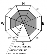
Moderate to high intensity snowfall and S winds this morning will create new wind slabs in near and above treeline terrain. The S wind direction versus the more common SW storm wind direction will create a different wind slab distribution than usual today. The vast majority of wind slab formation is expected on W-NW-N-NE-E-SE aspects, but could occur in some areas on S and SW aspects as well. Wind slabs could easily reach a foot or so thick today in the more efficiently wind loaded areas.

Use clues such as blowing snow, new cornice formations, and newly formed wind pillows to identify and avoid slopes with likely wind slab development.

Avalanche Problem 2: Storm Slab
  • Type ?
  • Aspect/Elevation ?
  • Likelihood ?
    Certain
    Very Likely
    Likely
    Possible
    Unlikely
  • Size ?
    Historic
    Very Large
    Large
    Small

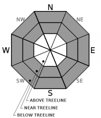
Fairly high intensity snowfall this morning will create storm slabs in wind protected areas near and below treeline. In some but not all of the large below treeline open areas there is a chance that these new storm slabs are sitting on top of surface hoar which persisted at the old/new snow interface. Anywhere where this is the case, storm slabs will be very easily triggered and avalanches could occur on lower angle slopes down to around 30 degrees.

Look for clues such as snow surface cracking in low angle terrain for indications where unstable storm slabs exist. Keep in mind that areas with problematic surface hoar could exist on some slopes but not others nearby. This means that observations of stability on one slope will not necessarily apply to an adjacent or other nearby slope in the area.

Avalanche Problem 3: Loose Wet
  • Type ?
  • Aspect/Elevation ?
  • Likelihood ?
    Certain
    Very Likely
    Likely
    Possible
    Unlikely
  • Size ?
    Historic
    Very Large
    Large
    Small

Areas of rain on snow today, especially new snow will be prone to wet loose avalanche activity. This is most likely to occur below 6,500' to 7,500' on slopes steeper than 35 degrees. Wet loose avalanche activity today could be either natural or human triggered. Terrain traps such as creek beds and road cuts could magnify the depth of avalanche debris associated with otherwise small wet loose avalanches.

recent observations

Recent observations from around the forecast area over the past several days have indicated that the existing snowpack is well consolidated and have revealed no problematic weak layers deeper in the snowpack. A few areas of surface hoar were noted to persist yesterday afternoon in large open areas well below treeline. Old snow surfaces generally consist of melt freeze crust on SE-S-SW aspects and well settled but still unconsolidated snow on NW-N-NE aspects.

Weather and CURRENT CONDITIONS
weather summary

The first in a series of storm systems is impacting the forecast area this morning. A period of moderate to high intensity snowfall is expected this morning before precipitation intensity decreases dramatically this afternoon. Snow level started around 5,000' early this morning and is expected to rise to 6,500' to 7,500' today. There is a slight chance snow levels could rise higher in some areas. Some partial clearing of cloud cover could occur this afternoon during the lull in precipitation intensity. Following this afternoon's lull, the second more powerful wave of the storm will bring moderate to high intensity precipitation late tonight into Friday. Snow level is expected to fall to around 6,500' on Friday. Ridgetop winds are out of the S this morning and are forecast to shift to the SW this afternoon. Wind speeds in the moderate to strong range will become strong to gale force tonight and tomorrow. Expect gusts to 65 mph today increasing to 100 mph tonight into Friday.

CONDITIONS ALONG THE SIERRA CREST BETWEEN 8200 FT. AND 9200 FT. IN THE LAST 24 HOURS
6am temperature: 26 to 28 deg. F.
Max. temperature: 35 to 40 deg. F.
Average ridgetop wind direction: S
Average ridgetop wind speed: 50 mph
Maximum ridgetop wind gust: 92 mph
New snowfall: 2 to 4 inches
Total snow depth: 99 to 121 inches
Two-Day Mountain Weather Forecast Produced in partnership with the Reno NWS
For 7000 ft. to 8000 ft.
Thursday Thursday Night Friday
Weather: Cloudy skies becoming mostly cloudy with snow in the morning. Snow or rain in the afternoon with snow level 6,500' to 7,500'. Cloudy skies with a mix of rain and snow. Cloudy skies with snow.
Temperatures: 32 to 37 deg. F. 27 to 32 deg. F. 29 to 34 deg. F.
Mid Slope Winds: S shifting to SW in the afternoon. SW SW
Wind Speed: 15 to 25 mph with gusts to 45 mph. 15 to 25 mph with gusts to 45 mph. 20 to 30 mph with gusts to 55 mph.
Expected snowfall: 3 to 6 1 to 4 Likely 4 to 10 in, possibly 10 to 14
For 8000 ft. to 9000 ft.
Thursday Thursday Night Friday
Weather: Cloudy skies becoming mostly cloudy with snow, mainly in the morning. Cloudy skies with snow. Cloudy skies with snow.
Temperatures: 27 to 33 deg. F. 24 to 29 deg. F. 26 to 31 deg. F.
Ridge Top Winds: S shifting to SW in the afternoon. SW SW
Wind Speed: 30 to 45 mph, shifting and decreasing to 25 to 35 mph in the afternoon. Gusts to 65 mph. 25 to 35 mph. Gusts to 65 mph increasing to 90 mph after midnight. 40 to 60 mph with gusts to 100 mph.
Expected snowfall: 4 to 7 1 to 4 Likely 4 to 10 in, possibly 10 to 16
Disclaimer

This avalanche advisory is provided through a partnership between the Tahoe National Forest and the Sierra Avalanche Center. This advisory covers the Central Sierra Nevada Mountains between Yuba Pass on the north and Ebbetts Pass on the south. Click here for a map of the forecast area. This advisory applies only to backcountry areas outside established ski area boundaries. This advisory describes general avalanche conditions and local variations always occur. This advisory expires 24 hours after the posted time unless otherwise noted. The information in this advisory is provided by the USDA Forest Service who is solely responsible for its content.

For a recorded version of the Avalanche Advisory call (530) 587-3558 x258