


For 7000 ft. to 8000 ft.
| Monday | Monday Night | Tuesday | |
|---|---|---|---|
| Weather: | Mostly cloudy. Snow showers possible in the morning, then scattered snow showers in the afternoon. | Mostly cloudy. Slight chance of snow showers. | Partly cloudy then becoming sunny. |
| Temperatures: | 22 to 27 deg. F. | 6 to 16 deg. F. | 29 to 34 deg. F. |
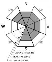
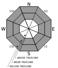
| Mid Slope Winds: | W | W | NW |
| Wind Speed: | 15 to 20mph. Gusts up to 45mph decreasing to 30 in the afternoon. | 10 to 15mph with gusts to 25mph becoming light in the evening. | Light winds |
| Expected snowfall: | Up to 2 | 0 | 0 |
For 8000 ft. to 9000 ft.
| Monday | Monday Night | Tuesday | |
|---|---|---|---|
| Weather: | Mostly cloudy. Snow likely in the morning then scattered snow showers in the afternoon. | Mostly cloudy. Slight chance of snow showers. | Partly cloudy then becoming sunny. |
| Temperatures: | 17 to 23 deg. F. | 6 to 14 deg. F. | 27 to 32 deg. F. |
| Ridge Top Winds: | W | SW | NW |
| Wind Speed: | 25 to 45mph with gusts to 85mph decreasing to 15 to 20mph with gusts to 40mph in the afternoon. | 10 to 15mph with gusts to 30mph. | 10 to 15mph with gusts to 35mph. |
| Expected snowfall: | Up to 2 | 0 | 0 |


