THIS AVALANCHE FORECAST EXPIRED ON March 1, 2017 @ 6:45 am
Avalanche Forecast published on February 28, 2017 @ 6:45 am
Issued by Brandon Schwartz - Tahoe National Forest

MODERATE avalanche danger will exist today at all elevations. Lingering wind slabs and developing wet loose avalanche problems are the concerns to manage today. Identify specific slopes of concern. Account for changing snowpack stability as daytime warming increases the likelihood of wet loose instability in sun exposed areas.

2. Moderate

?

Above Treeline
Heightened avalanche conditions on specific terrain features. Evaluate snow and terrain carefully; identify features of concern.

2. Moderate

?

Near Treeline
Heightened avalanche conditions on specific terrain features. Evaluate snow and terrain carefully; identify features of concern.

2. Moderate

?

Below Treeline
Heightened avalanche conditions on specific terrain features. Evaluate snow and terrain carefully; identify features of concern.
    Heightened avalanche conditions on specific terrain features. Evaluate snow and terrain carefully; identify features of concern.
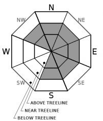
Avalanche Problem 1: Wind Slab
  • Type ?
  • Aspect/Elevation ?
  • Likelihood ?
    Certain
    Very Likely
    Likely
    Possible
    Unlikely
  • Size ?
    Historic
    Very Large
    Large
    Small

Wind slabs remain an ongoing concern in near treeline and above treeline terrain on NW-N-NE-E-SE-S aspects. Continued drifting snow yesterday combined with below average air temperatures may have slowed the rate of wind slab stabilization. Human triggered wind slab avalanches remain possible today.

Areas of instability will likely exist within surrounding areas of seemingly stable snow. Identify areas of recently wind drifted snow and avoid suspect slopes steeper then 35 degrees.

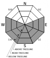
Avalanche Problem 2: Loose Wet
  • Type ?
  • Aspect/Elevation ?
  • Likelihood ?
    Certain
    Very Likely
    Likely
    Possible
    Unlikely
  • Size ?
    Historic
    Very Large
    Large
    Small

Warming air temperatures and decreasing cloud cover will allow for natural and human triggered wet loose avalanches to become increasingly widespread over the next few days. The vast majority of wet loose instability is expected to occur on E-SE-S-SW-W aspects.

Areas around exposed rocks and trees will heat up quickly. Avoid travel on slopes 35 degrees and steeper where roller balls are occurring.

recent observations

A wind slab avalanche occurred yesterday morning on Peak 9269' (West Shore Tahoe area) on an E to SE aspect 39 degree slope at 9,000'.  The avalanche was most likely human triggered and appeared to overrun the triggering party's skin track. Not all details regarding triggering of this avalanche are confirmed. Observations made yesterday on Hidden Peak (West Shore Tahoe area) and on Flagpole Peak (Echo Summit area) revealed mostly dry loose instability and some ongoing areas of blowing snow. Wind slabs were present but difficult to trigger.

Weather and CURRENT CONDITIONS
weather summary

Building high pressure will bring a gradual warming trend, sunny skies, and light winds to the forecast area over the next few days. Moderate speed SW ridgetop winds are decreasing this morning and are forecast to become light tonight. A brief period of light to moderate speed E winds are expected tomorrow morning. The next series of storm systems is expected to arrive this weekend.

CONDITIONS ALONG THE SIERRA CREST BETWEEN 8200 FT. AND 9200 FT. IN THE LAST 24 HOURS
6am temperature: 10 to 13 deg. F.
Max. temperature: 21 to 30 deg. F.
Average ridgetop wind direction: SW
Average ridgetop wind speed: 27 mph
Maximum ridgetop wind gust: 47 mph
New snowfall: 0 to trace inches
Total snow depth: 140 to 190 inches
Two-Day Mountain Weather Forecast Produced in partnership with the Reno NWS
For 7000 ft. to 8000 ft.
Tuesday Tuesday Night Wednesday
Weather: Partly cloudy skies, becoming sunny. Clear skies. Sunny skies.
Temperatures: 29 to 34 deg. F. 6 to 16 deg. F. 37 to 42 deg. F.
Mid Slope Winds: W Variable Variable
Wind Speed: Light winds. Gusts up to 25 mph in the morning. Light winds Light winds
Expected snowfall: 0 0 0
For 8000 ft. to 9000 ft.
Tuesday Tuesday Night Wednesday
Weather: Partly cloudy skies, becoming sunny. Clear skies. Sunny skies.
Temperatures: 27 to 32 deg. F. 7 to 15 deg. F. 35 to 40 deg. F.
Ridge Top Winds: W Variable E
Wind Speed: 10 to 15 mph. Gusts to 35 mph decreasing to 25 mph in the afternoon. Light winds 10 to 15 mph with gusts to 25 mph in the morning, becoming light.
Expected snowfall: 0 0 0
Disclaimer

This avalanche advisory is provided through a partnership between the Tahoe National Forest and the Sierra Avalanche Center. This advisory covers the Central Sierra Nevada Mountains between Yuba Pass on the north and Ebbetts Pass on the south. Click here for a map of the forecast area. This advisory applies only to backcountry areas outside established ski area boundaries. This advisory describes general avalanche conditions and local variations always occur. This advisory expires 24 hours after the posted time unless otherwise noted. The information in this advisory is provided by the USDA Forest Service who is solely responsible for its content.

For a recorded version of the Avalanche Advisory call (530) 587-3558 x258