


For 7000 ft. to 8000 ft.
| Wednesday | Wednesday Night | Thursday | |
|---|---|---|---|
| Weather: | Cloudy skies with snow. Blizzard conditions in the morning. | Cloudy skies with snow showers likely in the evening. A chance of snow after midnight. | Cloudy skies with snow. |
| Temperatures: | 27 to 32 deg. F. | 12 to 18 deg. F. | 21 to 26 deg. F. |
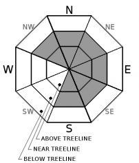
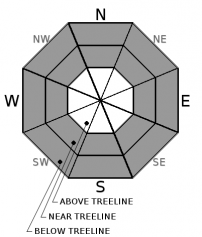
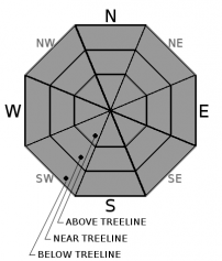
| Mid Slope Winds: | SW | SW | E |
| Wind Speed: | 20 to 35 mph with gusts to 60 mph. | 15 to 25 mph. Gusts to 40 mph decreasing to 30 mph after midnight. | Light winds |
| Expected snowfall: | Expected 3 to 8 in., Possible 8 to 12 | 1 to 3 | 2 to 5 |
For 8000 ft. to 9000 ft.
| Wednesday | Wednesday Night | Thursday | |
|---|---|---|---|
| Weather: | Cloudy skies with snow. Blizzard conditions in the morning. | Cloudy skies with snow showers likely in the evening. A chance of snow after midnight. | Cloudy skies with snow. |
| Temperatures: | 24 to 30 deg. F. | 10 to 15 deg. F. | 16 to 21 deg. F. |
| Ridge Top Winds: | SW | SW | E |
| Wind Speed: | 30 to 50 mph with gusts to 100 mph, decreasing to 25 to 40 mph with gusts to 85 mph in the afternoon. | 20 to 30 mph. Gusts to 70 mph, decreasing to 55 mph after midnight. | 10 to 15 mph. Gusts to 40 mph, decreasing to 30 mph in the afternoon. |
| Expected snowfall: | Expected 4 to 10 in., Possible 10 to 14 | 1 to 3 | 2 to 5 |


