


For 7000 ft. to 8000 ft.
| Thursday | Thursday Night | Friday | |
|---|---|---|---|
| Weather: | Cloudy. Snow. | Cloudy. Chance of snow. | Mostly cloudy then becoming partly cloudy. Chance of snow showers in the morning. |
| Temperatures: | 20 to 25 deg. F. | 11 to 17 deg. F. | 24 to 29 deg. F. |
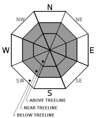
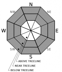
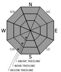
| Mid Slope Winds: | SW shifting to E | East shifting to NE | |
| Wind Speed: | SW winds 10mph becoming E 10 to 15mph. Gusts to 25mph. | East winds 10 to 15mph becoming NE 10 to 15 with gusts to 25mph after midnight. | Calm winds. |
| Expected snowfall: | Expected 5 to 10 in., Possible 10 to 14 | Expected up to 2 in., Possible 2 to 4 | Trace |
For 8000 ft. to 9000 ft.
| Thursday | Thursday Night | Friday | |
|---|---|---|---|
| Weather: | Cloudy. Snow | Cloudy. Snow likely in the evening then chance of snow after midnight. | Mostly cloudy then becoming partly cloudy. Chance of snow showers in the morning. |
| Temperatures: | 14 to 20 deg. F. | 10 to 15 deg. F. | 22 to 27 deg. F. |
| Ridge Top Winds: | SW shifting to E | NE | E |
| Wind Speed: | SW 10 to 15mph this morning becoming E 10 to 15mph with gusts to 40mph in the afternoon. | 15 to 20mph. Gusts up to 25mph increasing to 40mph after midnight. | 15 to 20 with gusts to 45mph. |
| Expected snowfall: | Expected 5 to 10 in., Possible 10 to 14 | Expected up to 2 in., Possible 2 to 4 | Trace |


