THIS AVALANCHE FORECAST EXPIRED ON January 15, 2017 @ 6:54 am
Avalanche Forecast published on January 14, 2017 @ 6:54 am
Issued by Andy Anderson - Tahoe National Forest - Sierra Avalanche Center

MODERATE avalanche danger exists at all elevations due to newly formed wind slabs and unlikely but not impossible lingering deep slabs. Human triggered avalanches may remain possible today especially in regards to the wind slabs that formed yesterday. Evaluate the snowpack and terrain carefully before committing to any route and use this information to identify and avoid areas of concern. This data can also help find safer areas to recreate where good snow conditions exist.

2. Moderate

?

Above Treeline
Heightened avalanche conditions on specific terrain features. Evaluate snow and terrain carefully; identify features of concern.

2. Moderate

?

Near Treeline
Heightened avalanche conditions on specific terrain features. Evaluate snow and terrain carefully; identify features of concern.

2. Moderate

?

Below Treeline
Heightened avalanche conditions on specific terrain features. Evaluate snow and terrain carefully; identify features of concern.
    Heightened avalanche conditions on specific terrain features. Evaluate snow and terrain carefully; identify features of concern.
Avalanche Problem 1: Wind Slab
  • Type ?
  • Aspect/Elevation ?
  • Likelihood ?
    Certain
    Very Likely
    Likely
    Possible
    Unlikely
  • Size ?
    Historic
    Very Large
    Large
    Small

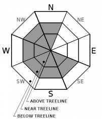
Strong east winds yesterday and light snow on windward aspects allowed wind slabs up to 2 ft. in depth to form near exposed ridgelines on the wind loaded NW-W-SW aspects and on cross-loaded N and S-SE aspects. Continued wind slab formation should remain limited today since the wind speeds have decreased, but human-triggered wind slab avalanches involving these new wind slabs could still remain possible today.

Use clues like new cornices, wind-drifted snow, blowing snow and ripples on the snow surface to identify where wind slabs may exist and avoid them. Large cornices still exist along many ridgelines even in areas where the east winds have scoured the slopes below them.

Avalanche Problem 2: Deep Slab
  • Type ?
  • Aspect/Elevation ?
  • Likelihood ?
    Certain
    Very Likely
    Likely
    Possible
    Unlikely
  • Size ?
    Historic
    Very Large
    Large
    Small

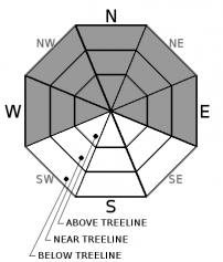
As the snowpack continues to consolidate, refreeze, and gain strength, deep slab avalanches become more and more unlikely. Deep wind slabs that formed during the storm that may linger in complex or extreme terrain on traditional wind-loaded aspects or deep slabs with a weak layer near the Dec. 15 rain crust may remain in higher elevation areas where little to no rain fell. While triggering one of these avalanches would be very difficult at this point, very large triggers like multiple people on a slope or huge cornice failures in isolated areas may still represent an unlikely but not impossible concern for today.

recent observations

Yesterday observations from Donner Peak and Mt. Judah near Donner Pass and the Frog Lake area near Carson Pass showed east winds forming wind slabs on exposed westerly aspects near ridgelines. Ski cuts and kicks on these newly wind loaded slopes produced shooting cracks up to 40 ft. and one wind slab avalanche on a test slope on Donner Peak. Most of these wind slabs measured 6 to 18 inches in depth with one topping out closer to 2 ft and did not extend very far downslope. In Indian Valley between Blue Lakes and Highway 4 and on Carson Pass freezing fog had created a very thin crust on the snow surface.  Snowmobile cuts on numerous test slopes in the Indian Valley area did not produce signs of instability. Snowpit data in that area showed good bonding at the Jan. 9th rain crust and no signs of instability. Signs of settlement and consolidation including settlement cracks around trees existed in all locations. Observations also revealed large, deep holes in the snowpack that extended to creeks or wet ground. Depending on visibility and terrain these holes could prove difficult to see.  

Weather and CURRENT CONDITIONS
weather summary

The forecast calls for daytime highs in the low 30's above 7000 ft. today and tomorrow with overnight lows in the upper teens. Some cloud cover may persist over the area this morning. This cloud cover should decrease some this afternoon and tonight before increasing again tomorrow. The strong east winds have decreased and should remain light to moderate for the next 36 hours. 

CONDITIONS ALONG THE SIERRA CREST BETWEEN 8200 FT. AND 9200 FT. IN THE LAST 24 HOURS
6am temperature: 17 to 23 deg. F.
Max. temperature: 23 to 26 deg. F.
Average ridgetop wind direction: East
Average ridgetop wind speed: Before midnight: 30 mph | After midnight: 15 mph
Maximum ridgetop wind gust: 91 mph
New snowfall: 0 inches
Total snow depth: 85 to 111 inches
Two-Day Mountain Weather Forecast Produced in partnership with the Reno NWS
For 7000 ft. to 8000 ft.
Saturday Saturday Night Sunday
Weather: Mostly cloudy becoming partly cloudy Partly cloudy Partly cloudy becoming mostly cloudy with a slight chance (10-15%) of snow showers in the afternoon
Temperatures: 30 to 35 deg. F. 14 to 22 deg. F. 31 to 36 deg. F.
Mid Slope Winds: Variable Variable East
Wind Speed: Light Light with gusts to 25 mph after midnight 10 to 15 mph in the morning decreasing in the afternoon. Gusts to 25 mph
Expected snowfall: 0 0 0
For 8000 ft. to 9000 ft.
Saturday Saturday Night Sunday
Weather: Mostly cloudy becoming partly cloudy Partly cloudy Partly cloudy becoming mostly cloudy with a slight chance (10-15%) of snow showers in the afternoon
Temperatures: 30 to 35 deg. F. 16 to 22 deg. F. 30 to 35 deg. F.
Ridge Top Winds: Variable East Northeast
Wind Speed: Light with gusts to 25 mph in the afternoon 15 to 20 mph with gusts to 30 mph increasing to 40 mph after midnight 15 to 25 mph with gusts to 45 mph
Expected snowfall: 0 0 0
Disclaimer

This avalanche advisory is provided through a partnership between the Tahoe National Forest and the Sierra Avalanche Center. This advisory covers the Central Sierra Nevada Mountains between Yuba Pass on the north and Ebbetts Pass on the south. Click here for a map of the forecast area. This advisory applies only to backcountry areas outside established ski area boundaries. This advisory describes general avalanche conditions and local variations always occur. This advisory expires 24 hours after the posted time unless otherwise noted. The information in this advisory is provided by the USDA Forest Service who is solely responsible for its content.

For a recorded version of the Avalanche Advisory call (530) 587-3558 x258