THIS AVALANCHE FORECAST EXPIRED ON January 16, 2017 @ 6:58 am
Avalanche Forecast published on January 15, 2017 @ 6:58 am
Issued by Andy Anderson - Tahoe National Forest - Sierra Avalanche Center

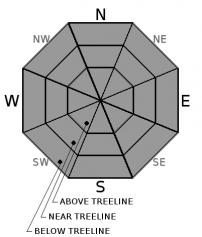
The avalanche danger has decreased to LOW. Low avalanche danger does not mean no avalanche danger. Unstable snow may still exist on isolated terrain features and small avalanches could still occur in isolated or extreme terrain. Continue to evaluate the terrain and snowpack while traveling in the backcountry to identify where these isolated areas of unstable snow may still exist and avoid those slopes.

1. Low

?

Above Treeline
Generally safe avalanche conditions. Watch for unstable snow on isolated terrain features.

1. Low

?

Near Treeline
Generally safe avalanche conditions. Watch for unstable snow on isolated terrain features.

1. Low

?

Below Treeline
Generally safe avalanche conditions. Watch for unstable snow on isolated terrain features.
    Generally safe avalanche conditions. Watch for unstable snow on isolated terrain features.
Avalanche Problem 1: Normal Caution
  • Type ?
  • Aspect/Elevation ?

Avalanches have become unlikely as the snowpack has consolidated and gained strength since the storm. Unlikely does not mean impossible, and unstable snow could still exist on isolated terrain features. Steep, complex, and extreme terrain and unsupported slopes represent the best places to find these isolated areas of instability where a person may still encounter a lingering avalanche issue like a wind slab or a cornice failure. Couloirs, cliffy areas, gullies, and hanging snowfields are just a few examples of complex and extreme terrain. Large cornices still exist along many ridgelines, and in some areas, they could still break under the weight of a person or multiple people.

recent observations

Observations yesterday on Tamarack Peak, Hidden Peak, and Castle Peak all revealed continued consolidation in the snowpack. Snow pit tests on Tamarack Peak and Hidden Peak showed good bonding between and within the snowpack layers including the Jan. 9th rain crust. Ski cuts on test slopes in the Tamarack Peak area also did not reveal signs of instability. On Tamarack Peak a widespread, thin, breakable rime crust with surface hoar on top of it existed. Surface hoar was also reported on Hidden Peak. General observations from Castle Peak did not show significant signs of instability, but wind affected snow existed on most open aspects in near and above treeline terrain. A party in Deep Creek on Billy's Peak reported a small human triggered wind slab on a steep N-NE aspect near a previous deep slab that occurred last week. 

Weather and CURRENT CONDITIONS
weather summary

Some low level cloud cover could continue through today with sunnier conditions at the upper elevations. A small system moving down the CA coast today may allow for some light snow flurries this afternoon before skies start to clear overnight. Expect a sunny day with daytime highs about 5 degrees warmer than today for Monday. The forecast calls for the light to moderate east winds to linger through tomorrow with some stronger gusts along the ridgetops tonight and tomorrow. 

CONDITIONS ALONG THE SIERRA CREST BETWEEN 8200 FT. AND 9200 FT. IN THE LAST 24 HOURS
6am temperature: 17 to 26 deg. F.
Max. temperature: 34 to 41 deg. F.
Average ridgetop wind direction: East and northeast
Average ridgetop wind speed: 10 mph
Maximum ridgetop wind gust: 22 mph
New snowfall: 0 inches
Total snow depth: 82 to 110 inches
Two-Day Mountain Weather Forecast Produced in partnership with the Reno NWS
For 7000 ft. to 8000 ft.
Sunday Sunday Night Monday
Weather: Partly cloudy with slight chance of very light snow in the afternoon Partly cloudy Sunny
Temperatures: 30 to 35 deg. F. 15 to 21 deg. F. 36 to 41 deg. F.
Mid Slope Winds: East Variable Variable
Wind Speed: 10 to 15 mph with gusts to 25 mph decreasing in the afternoon Light Light
Expected snowfall: 0 0 0
For 8000 ft. to 9000 ft.
Sunday Sunday Night Monday
Weather: Partly cloudy with slight chance of very light snow in the afternoon Partly cloudy Sunny
Temperatures: 30 to 35 deg. F. 15 to 20 deg. F. 36 to 41 deg. F.
Ridge Top Winds: Northeast East Northeast
Wind Speed: 15 to 25 mph with gusts to 45 mph 15 to 25 mph with gusts to 60 mph 15 to 25 mph with gusts to 60 mph decreasing to 50 mph in the afternoon`
Expected snowfall: 0 0 0
Disclaimer

This avalanche advisory is provided through a partnership between the Tahoe National Forest and the Sierra Avalanche Center. This advisory covers the Central Sierra Nevada Mountains between Yuba Pass on the north and Ebbetts Pass on the south. Click here for a map of the forecast area. This advisory applies only to backcountry areas outside established ski area boundaries. This advisory describes general avalanche conditions and local variations always occur. This advisory expires 24 hours after the posted time unless otherwise noted. The information in this advisory is provided by the USDA Forest Service who is solely responsible for its content.

For a recorded version of the Avalanche Advisory call (530) 587-3558 x258