


For 7000 ft. to 8000 ft.
| Thursday | Thursday Night | Friday | |
|---|---|---|---|
| Weather: | Cloudy. Snow in the morning then chance of snow showers in the afternoon. | Cloudy. Chance of snow showers in the evening then snow showers likely after midnight. | Cloudy. Snow. |
| Temperatures: | 25 to 30 deg. F. | 17 to 22 deg. F. | 26 to 31 deg. F. |
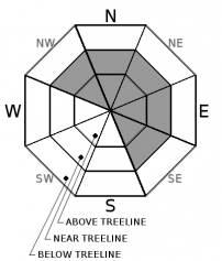
| Mid Slope Winds: | SW | SW | S |
| Wind Speed: | 15 to 25mph. Gusts up to 60mph decreasing to 35mph in the afternoon. | 15 to 20mph. Gusts up to 30mph increasing to 40mph after midnight. | 15 to 25mph with gusts to 55mph. |
| Expected snowfall: | Up to 2 | Up to 2 | 4 to 8 |
For 8000 ft. to 9000 ft.
| Thursday | Thursday Night | Friday | |
|---|---|---|---|
| Weather: | Cloudy. Snow in the morning then snow showers likely in the afternoon. | Cloudy. Chance of snow showers in the evening then snow showers likely after midnight. | Cloudy. Snow. |
| Temperatures: | 22 to 28 deg. F. | 15 to 20 deg. F. | 23 to 29 deg. F. |
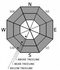
| Ridge Top Winds: | SW | SW | SW |
| Wind Speed: | 30 to 40 with gusts to 85mph decreasing to 15 to 25mph with gust to 50mph in the afternoon. | 20 to 30mph. Gusts up to 50mph increasing to 65mph after midnight. | 30 to 45mph. Gusts up to 85mph increasing to 100mph in the afternoon. |
| Expected snowfall: | 1 to 2 | 1 to 2 | 4 to 8 |


