THIS AVALANCHE FORECAST EXPIRED ON March 11, 2017 @ 6:58 am
Avalanche Forecast published on March 10, 2017 @ 6:58 am
Issued by Andy Anderson - Tahoe National Forest - Sierra Avalanche Center

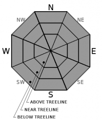
LOW avalanche danger this morning will increase to MODERATE avalanche danger today as loose wet avalanches become possible. If any areas recieve rain today, loose wet avalanche activity will be more widespread in those areas. Evaluate snow and terrain carefully and move to slopes with colder more frozen snow once signs of loose wet instabilities like roller balls, pinwheels, or sinking deep into wet snow start to occur. 

2. Moderate

?

Above Treeline
Heightened avalanche conditions on specific terrain features. Evaluate snow and terrain carefully; identify features of concern.

2. Moderate

?

Near Treeline
Heightened avalanche conditions on specific terrain features. Evaluate snow and terrain carefully; identify features of concern.

2. Moderate

?

Below Treeline
Heightened avalanche conditions on specific terrain features. Evaluate snow and terrain carefully; identify features of concern.
    Heightened avalanche conditions on specific terrain features. Evaluate snow and terrain carefully; identify features of concern.
Avalanche Problem 1: Loose Wet
  • Type ?
  • Aspect/Elevation ?
  • Likelihood ?
    Certain
    Very Likely
    Likely
    Possible
    Unlikely
  • Size ?
    Historic
    Very Large
    Large
    Small

Slightly cooler temperatures and widespread cloud cover could work to limit the extent of the wet snow instabilities that form today, but overnight temperatures above freezing, warm daytime temperatures, and possible light rain will mean that loose wet instabilities like roller balls, pinwheels, and loose point release avalanches could become possible again today. While wet snow may be more prevalent on the warmer E-SE-S-SW-W aspects, wet snow instabilities could exist on any aspect today due to the cloud cover and the possible rain. If it does rain today or if the sun comes out wet snow instabilities will become more widespread. 

recent observations

Yesterday observations from Incline Lake Peak and the Carson Pass area showed wet sticky snow that had not been through enough melt freeze cycles to become corn on the sun-exposed E-SE-S-SW-W aspects at all elevations. Below this wet surface snow cold dry snow still remained. Ski cuts and ski kicks in both areas triggered loose wet instabilities like roller balls and pinwheels. Other natural signs of loose wet instability existed in both areas. In the drainage between Incline Lake Peak and Rose Knob Peak, the skier triggered pinwheels reached up to ~ 8 ft. in diameter. Some areas of soft cold snow existed on N aspects above 9200 ft. on Incline Lake Peak. Below that elevation, wet sticky snow and breakable crusts existed on northerly aspects

Weather and CURRENT CONDITIONS
weather summary

The cloud cover that moved into the area overnight should remain in place today due to a storm moving through the Pacific Northwest. These clouds bring a slight (15%) chance of light rain or snow showers with them for areas north of Highway 50. Snow level should remain high between 8000 and 9000 ft. Despite the cloud cover, temperatures should remain warm with daytime highs in the 40's above 8000 ft. and upper 40's to low 50's above 7000 ft. The cloud cover should start to disperse tonight and warmer sunnier weather should return to the region tomorrow. 

CONDITIONS ALONG THE SIERRA CREST BETWEEN 8200 FT. AND 9200 FT. IN THE LAST 24 HOURS
6am temperature: 34 to 41 deg. F.
Max. temperature: 45 to 54 deg. F.
Average ridgetop wind direction: Southwest
Average ridgetop wind speed: 20 to 25 mph
Maximum ridgetop wind gust: 44 mph
New snowfall: 0 inches
Total snow depth: 132 to 188 inches
Two-Day Mountain Weather Forecast Produced in partnership with the Reno NWS
For 7000 ft. to 8000 ft.
Friday Friday Night Saturday
Weather: Mostly cloudy with a slight chance of rain or snow in the afternoon Partly cloudy becoming clear Partly cloudy
Temperatures: 40 to 50 deg. F. 24 to 34 deg. F. 46 to 56 deg. F.
Mid Slope Winds: Southwest Variable Variable
Wind Speed: 10 to 15 mph with gusts to 25 mph in the morning becoming light in the afternoon Light Light
Expected snowfall: 0 0 0
For 8000 ft. to 9000 ft.
Friday Friday Night Saturday
Weather: Mostly cloudy with a slight chance of rain or snow in the afternoon Partly cloudy becoming clear Partly cloudy
Temperatures: 35 to 45 deg. F. 25 to 35 deg. F. 37 to 47 deg. F.
Ridge Top Winds: West Northwest West
Wind Speed: 10 to 20 mph with gusts to 35 mph 10 mph 10 to 15 mph with gusts to 30 mph
Expected snowfall: 0 0 0
Disclaimer

This avalanche advisory is provided through a partnership between the Tahoe National Forest and the Sierra Avalanche Center. This advisory covers the Central Sierra Nevada Mountains between Yuba Pass on the north and Ebbetts Pass on the south. Click here for a map of the forecast area. This advisory applies only to backcountry areas outside established ski area boundaries. This advisory describes general avalanche conditions and local variations always occur. This advisory expires 24 hours after the posted time unless otherwise noted. The information in this advisory is provided by the USDA Forest Service who is solely responsible for its content.

For a recorded version of the Avalanche Advisory call (530) 587-3558 x258