THIS AVALANCHE FORECAST EXPIRED ON March 17, 2017 @ 6:59 am
Avalanche Forecast published on March 16, 2017 @ 6:59 am
Issued by Andy Anderson - Tahoe National Forest - Sierra Avalanche Center

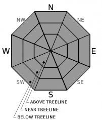
LOW avalanche danger exists this morning. The avalanche danger will increase to MODERATE as loose wet avalanches become possible due to daytime warming and intense spring sunshine. Evaluate snow and terrain carefully and move to less steep slopes or slopes with colder more frozen snow once the snow becomes wet and unsupportable. Avoid slopes below large cornices and glide cracks. 

2. Moderate

?

Above Treeline
Heightened avalanche conditions on specific terrain features. Evaluate snow and terrain carefully; identify features of concern.

2. Moderate

?

Near Treeline
Heightened avalanche conditions on specific terrain features. Evaluate snow and terrain carefully; identify features of concern.

2. Moderate

?

Below Treeline
Heightened avalanche conditions on specific terrain features. Evaluate snow and terrain carefully; identify features of concern.
    Heightened avalanche conditions on specific terrain features. Evaluate snow and terrain carefully; identify features of concern.
Avalanche Problem 1: Loose Wet
  • Type ?
  • Aspect/Elevation ?
  • Likelihood ?
    Certain
    Very Likely
    Likely
    Possible
    Unlikely
  • Size ?
    Historic
    Very Large
    Large
    Small

Loose wet avalanche activity will become possible again today on steep slopes where wet snow exists as the day warms up. Clear skies in some areas should have allowed a thin refreeze to occur despite the above freezing overnight temperatures. Warmer daytime temperatures and intense March sunshine will quickly melt through this thin refreeze leaving deep wet snow on slopes early in the day especially on the sun-exposed E-SE-S-SW-W aspects. Loose wet avalanche activity has the potential to be more widespread and larger today than yesterday on these aspects and could occur on some isolated northerly aspects as well. If more cloud cover develops over the region today, it may limit some of the loose wet activity. 

Once the snow becomes wet and unsupportable, it is time to move to a different aspect where colder snow exists or switch activities to avoid the wet snow. 

In addition to the wet snow potential, large cornices still exist above many slopes and glide cracks have opened on some steep slopes. Numerous cornice collapses have occurred during the warm weather, and at least one has triggered a loose wet avalanche large enough to bury a person. It is very difficult to predict when these cornice failures will occur or when glide cracks will release as glide avalanches. Due to their size, unpredictability, and serious consequences, it is best to avoid areas below glide cracks and large cornice features during any warm periods.

recent observations

Yesterday observations in the Donner Summit area, showed wet snow on all aspects. Deep wet snow already existed on E-SE-S-SW aspects by 10:30 am. While ski cuts on test slopes did not trigger any loose wet instabilities in the Black Wall area, numerous large cornice failures had occurred in this area in the last 24 to 48 hours. Some of these did trigger small loose wet avalanches as they entrained wet snow while sliding downhill. A larger natural cornice failure occurred on the east face of Donner Peak at 11:45 yesterday. About 40 ft. of cornice broke and fell onto the slopes below. As the large cornice pieces slid downhill they entrained wet snow and the resulting large loose wet snow avalanche involved enough snow to bury a person. It ran downslope for about 700 vertical ft. before coming to a stop in a lower angle section of the slope.

Weather and CURRENT CONDITIONS
weather summary

Some high clouds and strong winds may continue across the forecast area today due to a storm system moving through the Pacific Northwest. The winds and cloud cover should start to decrease this afternoon. Warm weather should still persist across the region with daytime highs in the upper 40's to low 50's above 7000 ft. Tomorrow brings sunnier skies, light winds, and daytime highs in the mid to upper 50's (maybe even low 60's) above 7000 ft. as high pressure returns to the area.

CONDITIONS ALONG THE SIERRA CREST BETWEEN 8200 FT. AND 9200 FT. IN THE LAST 24 HOURS
6am temperature: 35 to 42 deg. F.
Max. temperature: 45 to 51 deg. F.
Average ridgetop wind direction: Southwest
Average ridgetop wind speed: 45 to 55 mph
Maximum ridgetop wind gust: 95 mph
New snowfall: 0 inches
Total snow depth: 121 to 175 inches
Two-Day Mountain Weather Forecast Produced in partnership with the Reno NWS
For 7000 ft. to 8000 ft.
Thursday Thursday Night Friday
Weather: Mostly to partly cloudy with periods of sun in some areas Mostly cloudy becoming partly cloudy to mostly clear Partly cloudy to mostly sunny
Temperatures: 48 to 54 deg. F. 30 to 35 deg. F. 54 to 60 deg. F.
Mid Slope Winds: Southwest Southwest Southwest
Wind Speed: 10 to 15 mph with gusts to 35 mph 10 to 15 mph in the evening decreasing overnight. Gusts to 30 mph Light in the morning increasing to 10 to 15 mph in the afternoon. Gusts to 30 mph.
Expected snowfall: 0 0 0
For 8000 ft. to 9000 ft.
Thursday Thursday Night Friday
Weather: Mostly to partly cloudy with periods of sun in some areas Mostly cloudy becoming partly cloudy to mostly clear Partly cloudy to mostly sunny
Temperatures: 42 to 50 deg. F. 28 to 34 deg. F. 48 to 56 deg. F.
Ridge Top Winds: Southwest Southwest Southwest
Wind Speed: 25 to 40 mph with gusts to 65 mph decreasing to 25 to 35 mph with gusts to 50 mph in the afternoon 15 to 25 mph with gusts to 50 mph 15 to 25 mph with gusts to 50 mph
Expected snowfall: 0 0 0
Disclaimer

This avalanche advisory is provided through a partnership between the Tahoe National Forest and the Sierra Avalanche Center. This advisory covers the Central Sierra Nevada Mountains between Yuba Pass on the north and Ebbetts Pass on the south. Click here for a map of the forecast area. This advisory applies only to backcountry areas outside established ski area boundaries. This advisory describes general avalanche conditions and local variations always occur. This advisory expires 24 hours after the posted time unless otherwise noted. The information in this advisory is provided by the USDA Forest Service who is solely responsible for its content.

For a recorded version of the Avalanche Advisory call (530) 587-3558 x258