THIS AVALANCHE FORECAST EXPIRED ON March 18, 2017 @ 7:00 am
Avalanche Forecast published on March 17, 2017 @ 7:00 am
Issued by Andy Anderson - Tahoe National Forest - Sierra Avalanche Center

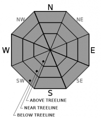
The avalanche danger will remain low for a brief period early this morning. As the day warms up, the avalanche danger will quickly rise to MODERATE as loose wet avalanches become possible. Evaluate snow and terrain carefully and move to less steep slopes or slopes with colder more frozen snow once the snow becomes wet and unsupportable. Avoid slopes below large cornices and glide cracks. 

2. Moderate

?

Above Treeline
Heightened avalanche conditions on specific terrain features. Evaluate snow and terrain carefully; identify features of concern.

2. Moderate

?

Near Treeline
Heightened avalanche conditions on specific terrain features. Evaluate snow and terrain carefully; identify features of concern.

2. Moderate

?

Below Treeline
Heightened avalanche conditions on specific terrain features. Evaluate snow and terrain carefully; identify features of concern.
    Heightened avalanche conditions on specific terrain features. Evaluate snow and terrain carefully; identify features of concern.
Avalanche Problem 1: Loose Wet
  • Type ?
  • Aspect/Elevation ?
  • Likelihood ?
    Certain
    Very Likely
    Likely
    Possible
    Unlikely
  • Size ?
    Historic
    Very Large
    Large
    Small

Despite above freezing overnight temperatures, mostly clear skies last night should have allowed a thin overnight refreeze in some areas. This refreeze will not last long due to the intense March sunshine and the very warm daytime temperatures. Loose wet avalanches will become possible again today once the refreeze melts. Expect deep wet unsupportable snow on slopes early in the day especially on the sun-exposed E-SE-S-SW-W aspects. Loose wet avalanche activity has the potential to be more widespread and larger today than yesterday on these aspects and could occur on some isolated northerly aspects as well.

Once the snow becomes wet and unsupportable, it is time to move to a different aspect where colder snow exists or switch activities to avoid the wet snow. 

In addition to the wet snow potential, large cornices still exist above many slopes and glide cracks have opened on some steep slopes. Numerous cornice collapses have occurred during the warm weather, and some have triggered a loose wet avalanches large enough to bury a person. It is very difficult to predict when these cornice failures will occur or when glide cracks will release as glide avalanches. Due to their size, unpredictability, and serious consequences, it is best to avoid areas below glide cracks and large cornice features during any warm periods.

recent observations

Yesterday observations found deep wet unsupportable snow on slopes below 8000 ft. On Mt. Tallac and near Twin Crags. Stepping off one's skis resulting in sinking into wet snow that was mid-shin to knee deep by noon. In the Twin Crags area, ski cuts on steep sun-exposed S facing test slopes at noon also triggered small loose wet sluffs that entrained the top 6 to 8 inches of wet snow. On Mt. Tallac, numerous cornice failures had occurred during this warm spell and one of those along the west ridge of Tallac had triggered a larger loose wet avalanche that likely occurred on March 13, 14, or 15. Above 8000 ft. on Mt. Tallac, mostly supportable spring snow conditions existed on E-SE aspects until about noon.

Weather and CURRENT CONDITIONS
weather summary

Today should be the warmest day of the week with daytime highs climbing into the upper 50's above 7000 ft. and possibly breaking 60 in a few areas in the mountains. Skies should remain mostly clear with until this afternoon and evening when some clouds could develop. The southwest winds should remain moderate during the day. Tonight cloud cover and southwest winds should increase as a weak storm system approaches the area. Expect strong southwest winds a cloudy skies tomorrow. This system also brings a slight chance for some light precipitation. If any moisture does reach the ground, it would likely fall as light rain since temperatures should remain well above normal and snow levels should remain between 8000 and 9000 ft. for tomorrow. 

CONDITIONS ALONG THE SIERRA CREST BETWEEN 8200 FT. AND 9200 FT. IN THE LAST 24 HOURS
6am temperature: 36 to 42 deg. F.
Max. temperature: 46 to 52 deg. F.
Average ridgetop wind direction: Southwest
Average ridgetop wind speed: 30 to 35 mph
Maximum ridgetop wind gust: 61 mph
New snowfall: 0 inches
Total snow depth: 119 to 173 inches
Two-Day Mountain Weather Forecast Produced in partnership with the Reno NWS
For 7000 ft. to 8000 ft.
Friday Friday Night Saturday
Weather: Partly cloudy to mostly sunny Mostly cloudy Mostly cloudy with a slight chance of rain showers
Temperatures: 55 to 60 deg. F. 34 to 39 deg. F. 48 to 54 deg. F.
Mid Slope Winds: Southwest Southwest Southwest
Wind Speed: 10 to 15 mph with gusts to 30 mph 10 to 15 mph with gusts to 40 mph 15 to 25 mph with gusts to 40 mph
Expected snowfall: 0 0 0
For 8000 ft. to 9000 ft.
Friday Friday Night Saturday
Weather: Partly cloudy to mostly sunny Mostly cloudy Mostly cloudy with a slight chance of rain or snow showers. Snow level 8000 to 9000 ft.
Temperatures: 48 to 56 deg. F. 34 to 39 deg. F. 43 to 51 deg. F.
Ridge Top Winds: Southwest Southwest Southwest
Wind Speed: 30 to 40 mph with gusts to 65 mph 30 to 45 mph with gusts to 70 mph increasing to 80 mph after midnight 30 to 50 mph with gusts to 100 mph decreasing to 85 mph in the afternoon
Expected snowfall: 0 0 0 to 1
Disclaimer

This avalanche advisory is provided through a partnership between the Tahoe National Forest and the Sierra Avalanche Center. This advisory covers the Central Sierra Nevada Mountains between Yuba Pass on the north and Ebbetts Pass on the south. Click here for a map of the forecast area. This advisory applies only to backcountry areas outside established ski area boundaries. This advisory describes general avalanche conditions and local variations always occur. This advisory expires 24 hours after the posted time unless otherwise noted. The information in this advisory is provided by the USDA Forest Service who is solely responsible for its content.

For a recorded version of the Avalanche Advisory call (530) 587-3558 x258