THIS AVALANCHE FORECAST EXPIRED ON March 19, 2017 @ 7:00 am
Avalanche Forecast published on March 18, 2017 @ 7:00 am
Issued by Andy Anderson - Tahoe National Forest - Sierra Avalanche Center

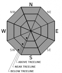
LOW avalanche danger may only exist for a brief period early this morning due to little to no overnight refreeze. As the day warms up, the avalanche danger will quickly rise to MODERATE as loose wet avalanches become possible. Evaluate snow and terrain carefully and move to less steep slopes or change activities once the snow becomes wet and unsupportable. Avoid slopes below large cornices and glide cracks. 

2. Moderate

?

Above Treeline
Heightened avalanche conditions on specific terrain features. Evaluate snow and terrain carefully; identify features of concern.

2. Moderate

?

Near Treeline
Heightened avalanche conditions on specific terrain features. Evaluate snow and terrain carefully; identify features of concern.

2. Moderate

?

Below Treeline
Heightened avalanche conditions on specific terrain features. Evaluate snow and terrain carefully; identify features of concern.
    Heightened avalanche conditions on specific terrain features. Evaluate snow and terrain carefully; identify features of concern.
Avalanche Problem 1: Loose Wet
  • Type ?
  • Aspect/Elevation ?
  • Likelihood ?
    Certain
    Very Likely
    Likely
    Possible
    Unlikely
  • Size ?
    Historic
    Very Large
    Large
    Small

Above freezing overnight temperatures and some overnight cloud cover should lead to a weaker overnight refreeze. While today's cloud cover and strong winds may slow down the melting process, it will not take much to melt through last night's weak refreeze. Loose wet avalanches will become possible again today once the refreeze melts. Expect deep wet unsupportable snow on slopes early in the day especially on the sun-exposed E-SE-S-SW-W aspects and on some northerly aspects as well. Most loose wet avalanche activity should remain smaller today, but larger loose wet activity is not impossible. If any areas receive rain, loose wet activity will be more widespread in those areas. 

Once the snow becomes wet and unsupportable, it is time to move to a different aspect where colder snow exists or switch activities to avoid the wet snow. 

In addition to the wet snow potential, large cornices still exist above many slopes and glide cracks have opened on some steep slopes. Numerous cornice collapses have occurred during the warm weather, and some have triggered loose wet avalanches large enough to bury a person. It is very difficult to predict when these cornice failures will occur or when glide cracks will release as glide avalanches. Due to their size, unpredictability, and serious consequences, it is best to avoid areas below glide cracks and large cornice features during any warm periods.

recent observations

Observations on Prosser Hill, Rose Knob Peak, and Echo Peak showed a mild overnight refreeze in open areas that softened to spring corn snow conditions in the 9 to 10:00 am time range yesterday. By 10:00 to 11am, the refreeze became unsupportable below 8500 ft. with knee deep wet snow on Prosser Hill, low elevations of Rose Knob Peak, and on Echo Peak. Numerous large cracks, sagging cornices, and cornice collapses were noted in the Echo Peak and Rose Knob areas as well. 

Weather and CURRENT CONDITIONS
weather summary

Some weak weather systems should begin to push through the region tonight and tomorrow while the main storm track stays focused on the Pacific Northwest. The main effects from these weak systems will be strong southwest winds, increased cloud cover, and slightly cooler temperatures. Expect daytime highs in the upper 40's to low 50's above 7000 ft. today and tomorrow. These small systems bring a slight chance of light precipitation with them for the northern part of the forecast area as well. Snow levels should remain high between 8000 and 9000 ft. If the precipitation does occur, some areas may see light rain below 9000 ft. 

CONDITIONS ALONG THE SIERRA CREST BETWEEN 8200 FT. AND 9200 FT. IN THE LAST 24 HOURS
6am temperature: 36 to 42 deg. F.
Max. temperature: 53 to 58 deg. F.
Average ridgetop wind direction: Southwest
Average ridgetop wind speed: 25 to 30 mph
Maximum ridgetop wind gust: 57 mph
New snowfall: 0 inches
Total snow depth: 117 to 171 inches
Two-Day Mountain Weather Forecast Produced in partnership with the Reno NWS
For 7000 ft. to 8000 ft.
Saturday Saturday Night Sunday
Weather: Partly cloudy with increasing clouds and a slight chance of rain showers this afternoon and evening in the northern part of the forecast area Mostly cloudy Mostly cloudy with a slight chance of rain showers in the afternoon
Temperatures: 49 to 55 deg. F. 31 to 36 deg. F. 47 to 53 deg. F.
Mid Slope Winds: Southwest Southwest South
Wind Speed: 20 to 30 mph with gusts to 50 mph 15 to 25 mph with gusts to 40 mph 15 to 25 mph with gusts to 40 mph
Expected snowfall: 0 0 0
For 8000 ft. to 9000 ft.
Saturday Saturday Night Sunday
Weather: Partly cloudy with increasing clouds and a slight chance of rain or snow showers this afternoon and evening in the northern part of the forecast area. Snow levels between 8000 and 9000 ft. Mostly cloudy Mostly cloudy with a slight chance of rain or snow showers in the afternoon. Snow levels between 8000 and 8500 ft.
Temperatures: 44 to 52 deg. F. 29 to 34 deg. F. 42 to 50 deg. F.
Ridge Top Winds: Southwest Southwest South
Wind Speed: 30 to 50 mph with gusts to 100 mph decreasing to 90 mph in the afternoon 30 to 45 mph with gusts to 90 mph 25 to 40 mph with gusts to 80 mph decreasing to 70 mph in the afternoon
Expected snowfall: 0 0 0
Disclaimer

This avalanche advisory is provided through a partnership between the Tahoe National Forest and the Sierra Avalanche Center. This advisory covers the Central Sierra Nevada Mountains between Yuba Pass on the north and Ebbetts Pass on the south. Click here for a map of the forecast area. This advisory applies only to backcountry areas outside established ski area boundaries. This advisory describes general avalanche conditions and local variations always occur. This advisory expires 24 hours after the posted time unless otherwise noted. The information in this advisory is provided by the USDA Forest Service who is solely responsible for its content.

For a recorded version of the Avalanche Advisory call (530) 587-3558 x258