THIS AVALANCHE FORECAST EXPIRED ON March 3, 2017 @ 7:00 am
Avalanche Forecast published on March 2, 2017 @ 7:00 am
Issued by Andy Anderson - Tahoe National Forest - Sierra Avalanche Center

Loose wet avalanches will become possible at all elevations as the day warms up. The avalanche danger will rise to MODERATE at all elevations today. Identify terrain where avalanche problems may exist and use this information to plan a travel route that avoids the problematic terrain.

2. Moderate

?

Above Treeline
Heightened avalanche conditions on specific terrain features. Evaluate snow and terrain carefully; identify features of concern.

2. Moderate

?

Near Treeline
Heightened avalanche conditions on specific terrain features. Evaluate snow and terrain carefully; identify features of concern.

2. Moderate

?

Below Treeline
Heightened avalanche conditions on specific terrain features. Evaluate snow and terrain carefully; identify features of concern.
    Heightened avalanche conditions on specific terrain features. Evaluate snow and terrain carefully; identify features of concern.
Avalanche Problem 1: Loose Wet
  • Type ?
  • Aspect/Elevation ?
  • Likelihood ?
    Certain
    Very Likely
    Likely
    Possible
    Unlikely
  • Size ?
    Historic
    Very Large
    Large
    Small

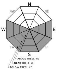
More sun and even warmer daytime temperatures today means that loose wet avalanches will become possible as the day warms up. Roller balls, pinwheels, and wet point release avalanches could occur today. Many of these should remain small, but some of them could entrain enough snow to knock a person or machine off balance or push them off course into more consequential terrain. Loose wet avalanche activity could occur on any sun-exposed E-SE-S-SW-W aspects with slopes 35 degrees or steeper. 

As the day warms up, pay attention to where small loose wet instabilities occur and where wet snow forms and avoid steep slopes on those aspects.

recent observations

Yesterday observations on Mt. Tallac and in the Becker/Talking area found soft unconsolidated snow on the northerly aspects and a mix of breakable crusts and warm wet snow on sun-exposed E-SE-S-SW-W aspects. Data collected in these areas did not reveal any lingering signs of unstable wind slabs or other slab formation. Some small loose wet roller balls did occur near rocks and cliff bands in both areas on SE-S-SW aspects. Some minor loose dry sluffs also occurred on steep NE facing terrain on Tallac.

Very large cornices still exist along many ridgelines. Ski kicks well away from the edge of cornices overhanging test slopes near Becker Peak did cause car-sized pieces of cornices to break off, but these pieces did not trigger any other signs of instability in the slopes below. 

Weather and CURRENT CONDITIONS
weather summary

Dry, warm, and sunny weather will continue due to a high-pressure ridge over the forecast area. The calm weather has allowed cold air to sink into the valleys in the mornings creating inversion conditions. This inversion should lift as the day warms up. Expect daytime highs in the upper 40's above 7000 ft. today and tomorrow. Due to another storm approaching the area for this weekend, light winds and clear skies should give way to increasing southwest winds and partly cloudy skies tomorrow. For more information on the upcoming storm check in with the Reno NWS. 

CONDITIONS ALONG THE SIERRA CREST BETWEEN 8200 FT. AND 9200 FT. IN THE LAST 24 HOURS
6am temperature: 22 to 33 deg. F.
Max. temperature: 39 to 46 deg. F.
Average ridgetop wind direction: NE to E to W to SW
Average ridgetop wind speed: 5 to 10 mph
Maximum ridgetop wind gust: 25 mph
New snowfall: 0 inches
Total snow depth: 134 to 183 inches
Two-Day Mountain Weather Forecast Produced in partnership with the Reno NWS
For 7000 ft. to 8000 ft.
Thursday Thursday Night Friday
Weather: Sunny Clear Partly cloudy
Temperatures: 44 to 49 deg. F. 14 to 24 deg. F. 44 to 49 deg. F.
Mid Slope Winds: Variable Variable Southwest
Wind Speed: Light Light Light in the morning increasing to 10 to 15 mph with gusts to 35 mph in the afternoon
Expected snowfall: 0 0 0
For 8000 ft. to 9000 ft.
Thursday Thursday Night Friday
Weather: Sunny Clear Partly cloudy
Temperatures: 43 to 48 deg. F. 18 to 23 deg. F. 42 to 47 deg. F.
Ridge Top Winds: Variable Southwest Southwest
Wind Speed: Light Light in the evening increasing to 10 to 15 mph with gusts to 25 mph after midnight 15 to 20 mph with gusts to 25 mph increasing to gusts to 55 mph in the afternoon
Expected snowfall: 0 0 0
Disclaimer

This avalanche advisory is provided through a partnership between the Tahoe National Forest and the Sierra Avalanche Center. This advisory covers the Central Sierra Nevada Mountains between Yuba Pass on the north and Ebbetts Pass on the south. Click here for a map of the forecast area. This advisory applies only to backcountry areas outside established ski area boundaries. This advisory describes general avalanche conditions and local variations always occur. This advisory expires 24 hours after the posted time unless otherwise noted. The information in this advisory is provided by the USDA Forest Service who is solely responsible for its content.

For a recorded version of the Avalanche Advisory call (530) 587-3558 x258