THIS AVALANCHE FORECAST EXPIRED ON March 30, 2017 @ 6:55 am
Avalanche Forecast published on March 29, 2017 @ 6:55 am
Issued by Brandon Schwartz - Tahoe National Forest

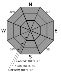
Early this morning avalanche danger is LOW for all elevations. As the day progresses, MODERATE avalanche danger will develop at all elevations as loose wet avalanche problems develop in response to daytime warming. Human triggered avalanche activity is possible today on steep slopes during the afternoon hours and could occur during the mid to late morning hours in some locations.

2. Moderate

?

Above Treeline
Heightened avalanche conditions on specific terrain features. Evaluate snow and terrain carefully; identify features of concern.

2. Moderate

?

Near Treeline
Heightened avalanche conditions on specific terrain features. Evaluate snow and terrain carefully; identify features of concern.

2. Moderate

?

Below Treeline
Heightened avalanche conditions on specific terrain features. Evaluate snow and terrain carefully; identify features of concern.
    Heightened avalanche conditions on specific terrain features. Evaluate snow and terrain carefully; identify features of concern.
Avalanche Problem 1: Loose Wet
  • Type ?
  • Aspect/Elevation ?
  • Likelihood ?
    Certain
    Very Likely
    Likely
    Possible
    Unlikely
  • Size ?
    Historic
    Very Large
    Large
    Small

Areas of loose wet snow avalanche problems are expected to form today on all aspects at all elevations as daytime warming melts surface snow on all aspects. Timing of when significant amounts of unstable surface wet snow form today could vary significantly around the forecast area due to the very wide range of air temperatures at the mid and upper elevations this morning. At any rate it will occur more quickly than yesterday. Human triggered avalanche activity will be possible this afternoon in all areas and could occur this morning is some of the warmer locations.

Pay attention to the amount and rate of surface wet snow formation. Avoid slopes over 35 degrees in slope angle where roller balls are occurring and/or where wet snow exceeds boot top height.

recent observations

Observations made yesterday on the N side of Carson Pass and on Incline Lake Peak (Mount Rose area) revealed much slower than expected snow surface warming due to brisk NE to E winds. Areas of roller ball activity were noted on Incline Lake Peak on a SE aspect at and below 8,500' starting just before 1 pm. Newly formed wind slabs were small and did not extend very far down slope. Frozen snow surfaces ranging from wind packed to supportable or breakable melt-freeze crust existed in most areas near and above treeline up until at least mid day. Areas of unconsolidated snow lingered in wind protected areas on NW-N-NE aspects below treeline. 

Weather and CURRENT CONDITIONS
weather summary

Air temperature inversion conditions have a fairly wide range of air temperatures at the mid and upper elevations this morning. Remote weather stations between 7,700' and 8,700' are reporting anywhere from the low 30s to low 40s. High pressure will last through today for sunny to partly cloudy skies, light winds, and well above freezing maximum daytime air temperatures. Cloud cover and ridgetop winds will increase tonight ahead of an approaching cold front expected to pass though the region tomorrow morning. For Thursday, expect snow showers, strong to gale force ridgetop winds ranging from SW to NW, and the possibility of lightning.


CONDITIONS ALONG THE SIERRA CREST BETWEEN 8200 FT. AND 9200 FT. IN THE LAST 24 HOURS
6am temperature: 30 to 42 deg. F.
Max. temperature: 35 to 43 deg. F.
Average ridgetop wind direction: E
Average ridgetop wind speed: 30 mph
Maximum ridgetop wind gust: 55 mph
New snowfall: 0 inches
Total snow depth: 121 to 175 inches
Two-Day Mountain Weather Forecast Produced in partnership with the Reno NWS
For 7000 ft. to 8000 ft.
Wednesday Wednesday Night Thursday
Weather: Partly cloudy skies. Partly cloudy skies, becoming mostly cloudy. A slight chance of showers after midnight. Cloudy skies with snow showers in the morning. A chance of snow showers in the afternoon. A slight chance of thunderstorms throughout the day.
Temperatures: 49 to 54 deg. F. 29 to 34 deg. F. 35 to 40 deg. F.
Mid Slope Winds: Variable W to SW SW shifting to NW
Wind Speed: Light winds 10 to 15 mph with gusts to 55 mph, increasing to 25 to 40 mph with gusts to 70 mph after midnight. 20 to 35 mph. Gusts up to 65 mph, decreasing to 55 mph in the afternoon.
Expected snowfall: 0 0 to trace Up to 2
For 8000 ft. to 9000 ft.
Wednesday Wednesday Night Thursday
Weather: Partly cloudy skies. Partly cloudy skies, becoming mostly cloudy. A slight chance of showers after midnight. Cloudy skies with snow showers in the morning. A chance of snow showers in the afternoon. A slight chance of thunderstorms throughout the day.
Temperatures: 46 to 52 deg. F. 26 to 31 deg. F. 31 to 36 deg. F.
Ridge Top Winds: Variable W SW shifting to NW
Wind Speed: Light winds 15 to 25 mph increasing to 35 to 55 mph after midnight. Gusts up to 95 mph. 30 to 45 mph with gusts to 90 mph, shifting and decreasing to 20 to 35 mph with gusts to 70 mph in the afternoon.
Expected snowfall: 0 0 to trace Up to 2
Disclaimer

This avalanche advisory is provided through a partnership between the Tahoe National Forest and the Sierra Avalanche Center. This advisory covers the Central Sierra Nevada Mountains between Yuba Pass on the north and Ebbetts Pass on the south. Click here for a map of the forecast area. This advisory applies only to backcountry areas outside established ski area boundaries. This advisory describes general avalanche conditions and local variations always occur. This advisory expires 24 hours after the posted time unless otherwise noted. The information in this advisory is provided by the USDA Forest Service who is solely responsible for its content.

For a recorded version of the Avalanche Advisory call (530) 587-3558 x258