

The last avalanche forecast for the 2023-2024 season will post on April 21st. Thank you to all who contributed to the avalanche center this season through observations, volunteer time, and/or financial contributions.
In partnership with: 
The last avalanche forecast for the 2023-2024 season will post on April 21st. Thank you to all who contributed to the avalanche center this season through observations, volunteer time, and/or financial contributions.
|
March 4, 2012 at 7:52 am |
|
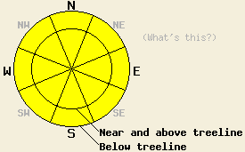
Avalanche danger is MODERATE both above and below treeline on NW-N-NE aspects on slopes 35 degrees and steeper due to ongoing deep slab instability. MODERATE avalanche danger is expected today both above and below treeline on E-SE-S-SW-W aspects on slopes 35 degrees and steeper due to wet snow instability forming in response to daytime warming. Large destructive human triggered avalanches are possible today. |
|
|
|
High pressure is firmly in place over the forecast area. Another day of clear skies and well above freezing air temperatures is forecast for today. An air temperature inversion is once again in place over much of the forecast area with most remote sensors above 7,000' indicating above freezing air temperatures in the mid to upper 30s this morning. A few stand out locations above 8,000' are at or just below freezing. Maximum daytime air temperatures above 7,000' are expected to warm into the mid 40s to low 50s, very similar to yesterday. Ridgetop winds have become light in speed out of the southwest after calm conditions for most of Saturday. Winds are forecast to further increase to light to moderate in speed this afternoon. Some amount of increasing cloud cover is forecast for tomorrow in addition to above freezing air temperatures and increasing southwest winds ahead of the next weather system expected to arrive over the forecast area early Tuesday morning.
Observations from around the forecast area over the past few days continue to indicate a trend of strengthening of short lived weak layers within the recent storm snow, in the frequently overstated way that is the stereotype of the Sierra Nevada snowpack. What is not at all typical for this region is the ongoing instability of the persistent weak layer of crusts and faceted snow just below the base of the recent storm snow. This is keeping concerns for human triggered deep slab avalanches ongoing. Yesterday on Silver Peak (Pole Creek area) propagation tests performed adjacent to a deep slab natural avalanche from March 1st on a N aspect in near treeline terrain indicated that this crust/facet weak layer still holds the potential to allow fractures to travel significant distances through the snowpack. Similar unstable snowpit data was reported from a below treeline N aspect in the Mount Rose region. A party ascending Trimmer Peak (Luther Pass area) reported collapsing the snowpack and triggering four loud whumpfs on a NW to N aspect below treeline both near rock outcrops and in wind loaded areas. On Jake's Peak (West Shore Tahoe area) and on Waterhouse Peak (Luther Pass area) less instability and more inconsistent test results were observed in below treeline areas on NW-N-NE aspects (click here for photos, videos, pit profiles, and more info on the above observations).
Today's Primary Avalanche Concern: Persistent Deep Slabs
As the recent storm snow continues to settle and gain strength, it is now a cohesive slab 2 to 4 feet thick sitting on top of the persistent weak layer of crusts and facets that formed in late January and early February. Triggering slab avalanches that fail within the recent new snow is unlikely at this time as the area of greatest relative weakness has shifted deeper within the snowpack to the crust/facet layer just below the bottom of the recent storm snow. This is where any snowpack failure at this time is likely to occur. This weak layer exists on NW-N-NE aspects both above and below treeline. Digging into the snowpack in these areas reveals a very easily identifiable layer and snow crystal change at the bottom of the storm snow that is obvious to both sight and feel. Large human triggered deep slab avalanches remain possible today both above and below treeline on NW-N-NE aspects. Areas near exposed rock outcrops and other similar trigger points are locations where triggering a deep slab avalanche is more likely. Observations are showing increasing variability regarding the stability of this weak layer around the forecast area. Locations of more stable observations are often not very far away from locations indicating significant ongoing instability. Exercise caution and conservative decision making as it is easy to travel from areas of stability to areas instability over a short distance.
Today's Secondary Avalanche Concern: Warming Instability
While some amount of snow surface refreeze was able to occur last night due to radiational cooling under clear skies, near and above freezing air temperatures at the mid and upper elevations will rapidly warm this morning. Areas of wet snow instability will form quickly again today on E-SE-S-SW-W aspects at all elevations. Natural and human triggered wet loose snow avalanche activity and roller ball activity are expected to continue as the recent new snow continues to transition from unconsolidated storm snow to consolidated melt-freeze conditions. This will be fueled by another day of above freezing air temperatures, minimal convective cooling of the snow surface by wind, and March levels of incoming solar radiation. Be conservative with travel above cliff bands, gullies, and other terrain traps that greatly magnify the consequences of being caught and carried by an otherwise inconsequential small loose snow avalanche.
Avalanche danger is MODERATE both above and below treeline on NW-N-NE aspects on slopes 35 degrees and steeper due to ongoing deep slab instability. MODERATE avalanche danger is expected today both above and below treeline on E-SE-S-SW-W aspects on slopes 35 degrees and steeper due to wet snow instability forming in response to daytime warming.
Large destructive human triggered avalanches are possible today.
| 0600 temperature: | 29 to 36 deg. F. |
| Max. temperature in the last 24 hours: | 45 to 53 deg. F. |
| Average wind direction during the last 24 hours: | East shifting to southwest |
| Average wind speed during the last 24 hours: | 6 mph |
| Maximum wind gust in the last 24 hours: | 25 mph |
| New snowfall in the last 24 hours: | O inches |
| Total snow depth: | 29 to 56 inches |
For 7000-8000 ft: |
|||
| Sunday: | Sunday Night: | Monday: | |
| Weather: | Sunny skies. | Clear skies. | Partly cloudy skies. |
| Temperatures: | 45 to 52 deg. F. | 24 to 32 deg. F. | 43 to 50 deg. F. |
| Wind direction: | SW | SW | SW |
| Wind speed: | Light winds increasing to 10 to 15 mph with gusts to 25 mph in the afternoon. | 15 to 20 mph. | 15 to 20 mph with gusts to 30 mph, increasing to 35 to 40 mph with gusts to 70 mph in the afternoon. |
| Expected snowfall: | O in. | O in. | O in. |
For 8000-9000 ft: |
|||
| Sunday: | Sunday Night: | Monday: | |
| Weather: | Sunny skies. | Clear skies. | Partly cloudy skies. |
| Temperatures: | 43 to 47 deg. F. | 27 to 33 deg. F. | 40 to 44 deg. F. |
| Wind direction: | SW | SW | SW |
| Wind speed: | Light winds increasing to 20 to 25 mph with gusts to 35 mph in the afternoon. | 20 to 30 mph with gusts to 35 mph. Gusts increasing to 45 mph after midnight. | 30 to 35 mph with gusts to 50 mph, increasing to 45 to 50 mph with gusts to 80 mph in the afternoon. |
| Expected snowfall: | O in. | O in. | O in. |


This website is owned and maintained by the non-profit arm of the Sierra Avalanche Center. Some of the content is updated by the USDA avalanche forecasters including the forecasts and some observational data. The USDA is not responsible for any advertising, fund-raising events/information, or sponsorship information, or other content not related to the forecasts and the data pertaining to the forecasts.